Appalachian History Series – Martins Fork Dam: Flood Control and a Four Bass Lake in Harlan County
On a calm summer morning Martins Fork Lake looks like a simple mountain lake. Tree covered ridges crowd tight to a long narrow pool of blue water. A swim beach and picnic shelters sit at one end. Anglers idle out from the ramp, hoping to hook largemouth, smallmouth, spotted, or Coosa bass on the same trip, something they cannot do anywhere else in Kentucky.
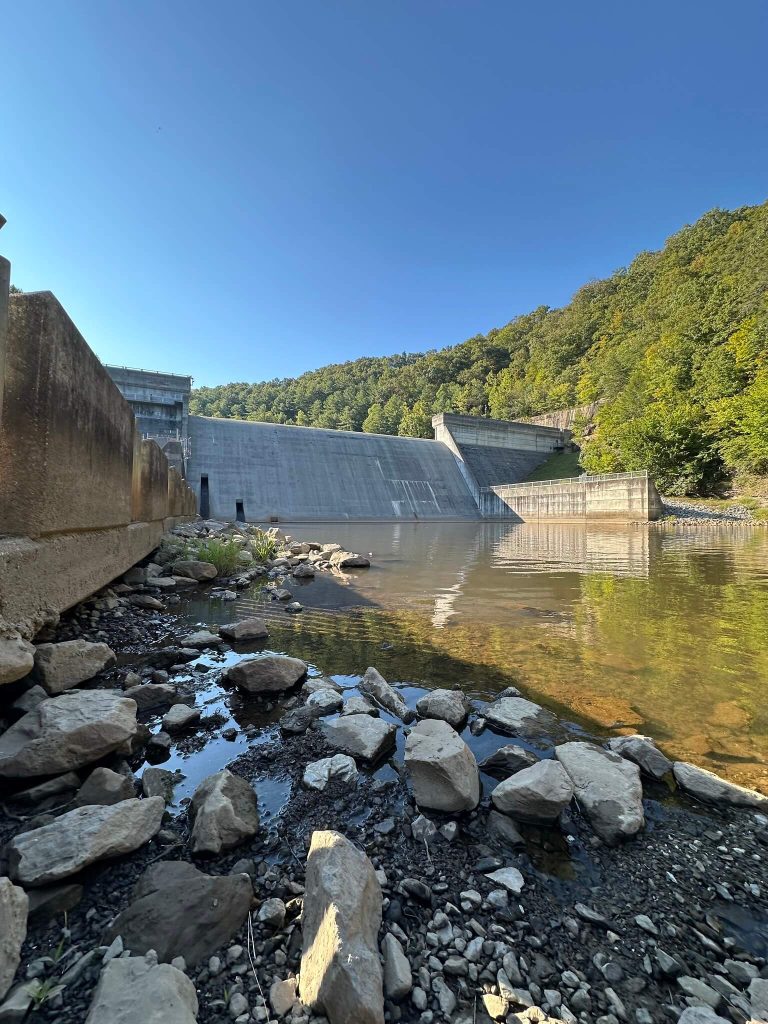
Hidden at the lower end of the valley is the reason this lake exists at all. Martins Fork Dam is a compact concrete structure wedged into a cut in Pine Mountain above the town of Smith. Inside its hollow galleries, engineers monitor instruments that track how the dam flexes under changing water loads. At the end of February 2025 they walked those galleries after the reservoir reached a record pool elevation, a real life test of a project that began as a line item in a 1960s flood control law.
This is the story of how Martins Fork Dam came to be, how it works, what it did during the 2025 high water event, and how the valley it flooded has become both a wildlife management area and one of the strangest little bass lakes in Kentucky.
From Flooded Streets to a Federal Project
In the mid twentieth century Harlan sat in a precarious place on the Cumberland River system. Martins Fork flows north from the Smith valley to meet the Clover Fork in town. The Clover Fork then joins the Poor Fork to form the main stem of the Cumberland River. Floods on any of these forks could swamp the low sections of town, and Harlan had lived through more than a few.
Congress responded with a basin wide plan to tame the Cumberland system. Martins Fork Lake was authorized in the Flood Control Act of October 27, 1965 as part of a package of small upland reservoirs designed to cut peak flows before they reached downstream cities.
As planning moved ahead the Corps prepared an environmental statement for Martins Fork in 1971, one of the early project studies written under the then new National Environmental Policy Act. The study described how a small mountain river valley would be transformed into a reservoir with a summer pool around 340 acres, with the option to store floodwater across as much as 578 acres when necessary. It predicted flood protection for Harlan and communities down the Cumberland, but also warned that the change would replace a free flowing stream and valley with a body of slack water and require relocations of roads, homes, and farmland in the Smith area.
Those tradeoffs would define Martins Fork from the start. A project meant to keep water off downtown streets in Harlan would permanently put water over hayfields, coal parcels, and a quiet country churchyard upstream.
Building Martins Fork: Concrete in a Narrow Gap
Martins Fork Dam occupies one of the narrow breaks in the ridge above Smith. Corps engineers designed a concrete flood control dam that could block the river at that choke point, hold water in the valley behind it, and then release it in a controlled way through gates and outlets at the base.
According to later project summaries from the Nashville District, construction on Martins Fork began in December 1973. The river was closed and the lake impounded in December 1978, and the project was declared ready for full beneficial use in January 1979.
On June 30, 1979 the Corps and local officials held a formal dedication at the dam. Kentucky senator Wendell Ford gave the keynote remarks that day, standing on the new concrete while the partly filled lake shone in the background.
Martins Fork was built only for flood control, water quality, recreation, and fish and wildlife purposes. A history of the Nashville District later noted that Martins Fork was unusual inside the district. All the other big Corps dams on the Cumberland carried hydroelectric turbines. Laurel River Lake had been built largely with hydropower and recreation in mind. Martins Fork, by contrast, was the only one of the group without a power plant, a reminder that this was first and foremost a flood project.
By the time the gates closed in 1978 a new road curved along the side of the valley above the future shoreline. Pieces of the old community of Smith had been shifted uphill. Down in the bottom, land that had once grown corn and supported small coal operations began to disappear under the rising pool.
How the Dam Works
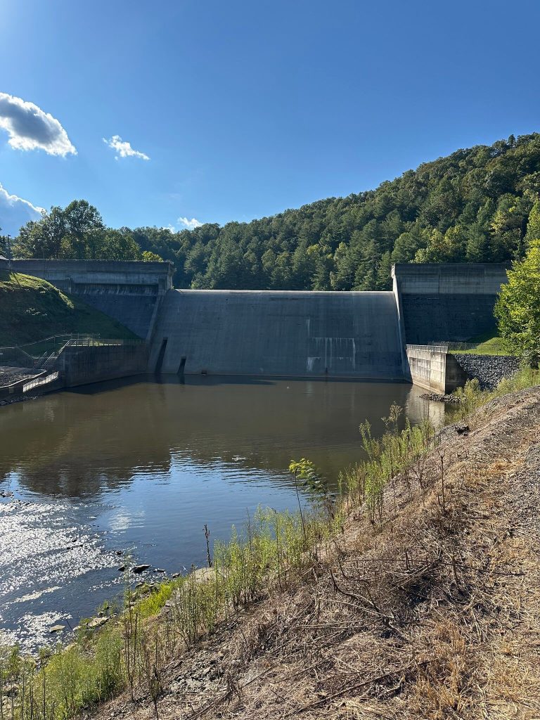
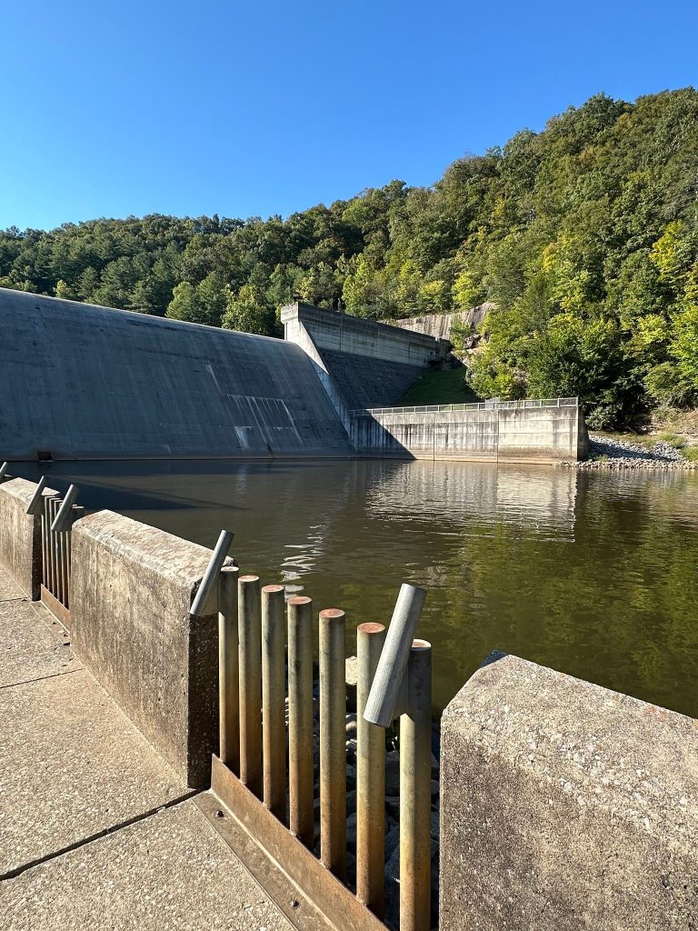
From the outside Martins Fork Dam looks like a heavy concrete wall with a broad sloping face and two tall abutments. Its most distinctive feature is the open spillway cut into the middle of the structure. That notch is designed to allow excess water to pour smoothly over the crest once the lake reaches a certain elevation, preventing water from overtopping the rest of the structure.
Behind the dam the lake level is held at different target elevations depending on the season. Corps documents describe a summer conservation pool that spreads across roughly 340 acres, a lower winter operating pool, and a maximum flood pool that can inundate up to about 578 acres when necessary. The total drainage area above the dam is only about 56 square miles, small compared to the huge main stem Cumberland reservoirs downstream, but precisely because the watershed is small it reacts quickly when heavy rain runs off the steep Harlan County ridges.
In normal weather Martins Fork passes a steady flow through low level outlets and keeps the lake at conservation pool. During wet periods the dam temporarily stores runoff, then releases it over days or weeks according to rules set out in its water control manual and coordinated with other Cumberland River Basin projects.
Even during quiet periods, the dam is instrumented and watched. A United States Geological Survey gauge at the dam records lake levels and water temperature and feeds a continuous record back to USGS and the Corps, giving managers and researchers a long term view of how the reservoir behaves.
The 2025 High Water Test
In late February 2025, heavy rain pushed Martins Fork through one of the biggest tests in its forty plus years of operation. As storm runoff filled the narrow valley, the lake climbed to a new record pool elevation of 1,332.49 feet, about a foot higher than the previous high mark set in April 1998.
When a Corps reservoir reaches a new high water record, policy requires a special inspection to confirm that the dam has weathered the strain. On February 25, 2025 a team of Nashville District engineers and geologists walked the galleries inside the dam, checked instruments, examined drains and joints, and compared their notes with previous inspections. Their report found no significant structural concerns. The dam had performed as expected.
Officials emphasized two facts that matter to people living downstream. First, Martins Fork Dam carries the lowest Dam Safety Action Classification rating in the Corps system, a category reserved for projects where the assessed risk is low and no urgent safety action is needed. Second, Martins Fork is unique in the Nashville District because of its open spillway and the way the project was designed never to rely on emergency actions to remain safe at high water.
The February 2025 flood event also illustrated how a relatively small Harlan County reservoir fits into larger regional flood management. While Martins Fork was filling, other Cumberland River dams were making their own adjustments. The Nashville District used its network of projects to reduce flood peaks across the watershed, holding water in some pools while releasing it from others to protect downstream communities in Kentucky and Tennessee.
For local residents the 2025 flood brought one more reminder that the quiet lake above Smith is still an active piece of federal infrastructure, working in the background every time a major storm sweeps across eastern Kentucky.
From Farms to Wildlife Management Area
Before the dam, the valley above Smith was a narrow bottomland threaded by Martins Fork and its tributaries. The 1971 environmental statement and the Corps master plan recorded a patchwork of small farms, family homes, a few businesses, roads, and church properties in the project area. The plan called for buying most of that bottomland, relocating segments of U.S. 421 and local roads, and raising portions of the community of Smith onto higher benches above the future shoreline.
When construction began, houses and community landmarks in the direct flood pool were either moved or razed. The old Smith Presbyterian Church, whose history survives in local newspaper clippings and blog posts, stood just up the valley from the future lake and became a symbol of what the project changed in the community.
After impoundment the federal government ended up with a ring of land around the new lake. Some of that acreage went into developed recreation areas near the dam and the main boat ramp. The rest became undeveloped project land. In partnership with the Kentucky Department of Fish and Wildlife Resources, much of that land was designated as Martins Fork Lake Wildlife Management Area, a public hunting and wildlife management tract of roughly 764 acres, more than 90 percent of it in second growth forest.
Today the WMA and adjacent Martins Fork WMA and State Natural Area tie the lake valley into a larger belt of public lands that includes Cumberland Gap National Historical Park and other state tracts along the Kentucky and Virginia line.
Bass Water and a Changing Lake
The Corps built Martins Fork as a flood control and water quality project, but over time the impoundment developed an unexpected claim to fame. According to a 2019 assessment by the Kentucky Department of Fish and Wildlife Resources, Martin’s Fork Lake is the only lake in Kentucky where anglers can target four species of black bass in a single reservoir: largemouth, smallmouth, spotted, and Coosa bass.
The same assessment describes Martins Fork as a multipurpose reservoir of a little over three hundred acres at normal pool, with additional opportunities for channel catfish, white crappie, bluegill, and a native strain walleye population. Angler guides and popular press articles echo that description, repeatedly calling Martins Fork Kentucky’s only reservoir with four black bass species and pointing out that the small, steep sided lake fishes differently from the sprawling flat water reservoirs farther west.
That unusual fishery did not happen by accident. Since the lake filled, biologists have stocked and monitored the bass populations and studied their genetics to understand where spotted and Coosa bass strains came from and how they interact. Recent genetics work has used fin clips and DNA markers from Martins Fork and other lakes to look for invasive Alabama bass genes and to protect native bass lineages.
The shape of the reservoir also affects how fish and people use it. Martins Fork is long and narrow, hemmed in by steep ridges that drop quickly into deep water. Summer stratification and a fairly shallow maximum depth mean that most fish stay relatively close to the surface in warm weather. For safety and shoreline protection, boats with motors larger than ten horsepower must run at idle speed only, a rule that keeps the lake quiet even on busy weekends.
The Corps and state agencies have also watched how sediment and nutrients move through the system. Early in the life of the project engineers modeled how silt would settle out of Martins Fork and how much storage capacity the reservoir would lose over time. Later water quality monitoring, including a nonpoint source report that highlighted the Martins Fork gage, tied the reservoir into statewide efforts to track pollution and aquatic health in Appalachian streams.
Taken together, the dam turned a free flowing mountain creek into a controlled lake, and that lake has turned into a long running experiment in how a small Appalachian reservoir behaves, both for fish and for people.
Recreation, Trails, and Local Memory
Walk the shoreline today and it is hard to imagine the construction site that once filled this valley. Where contractors parked heavy equipment in the late 1970s, visitors now spread blankets on the grass at the Martins Fork Recreation Area. The main public area near Smith includes a swimming beach, playground, picnic sites, and a boat ramp. Federal recreation listings and local tourism guides advertise the lake as a quiet place to camp, paddle, and fish close to Harlan.
Above the waterline the Cumberland Shadow Trail traces a loop through the Martins Fork Lake Wildlife Management Area. A 2018 Corps news release about that trail reads almost like a backcountry warning sign. Rangers reminded hikers that the route is rugged, that cell service is limited, and that people should be prepared for sudden weather changes in the high country around the lake.
For a time, the Corps also opened the inside of the dam itself to visitors. Public tours in 2013 and 2014 took people through the interior galleries and up above the spillway while park rangers explained how the structure worked and why flood control projects matter for regional safety.
Local photographers, bloggers, and Facebook groups have built a different kind of trail, an informal digital archive of Martins Fork. Posts share images of the dam under construction, the valley before impoundment, winter shots of the spillway covered in snow, and recent scenes of fishermen in the tailwater. Some community posts reshared coverage from the Harlan Daily Enterprise and the Corps after the 2025 inspection, reassuring residents that the dam remains stable.
All of this folds Martins Fork into the everyday life of Harlan County. The lake is a place to swim, fish, camp, hunt, and hike, but it is also a place where people remember the farms that once filled the valley and pay attention to water levels when hard rain starts upstream.
Conclusion
In the space of a few decades Martins Fork has gone from a line in a federal flood control bill to a fully realized piece of eastern Kentucky’s landscape. The dam has reduced downstream flood risk for Harlan, passed a record high water event in 2025 without structural problems, and created a small lake that biologists and anglers treat as a one of a kind four bass fishery.
Those benefits came with real costs in the Smith valley, where people traded bottomland and community landmarks for a reservoir and a promise of greater safety downstream. The environmental statement writers in 1971 described that trade in dry bureaucratic language, speaking of conversion of a free flowing stream and relocations, but for families on the ground it meant something more personal.
Half a century after authorization, Martins Fork Dam is part of the background of life in Harlan County. It is the concrete structure that keeps watch over flood peaks, the quiet lake where people camp and fish, and the setting for ongoing debates about development, conservation, and memory in an Appalachian valley reshaped by water.
Sources & Further Reading
U.S. Army Corps of Engineers, Nashville District. Environmental Statement: Martins Fork Lake, Cumberland River Basin, Kentucky (June 1971). Project purposes, predicted pool levels, and expected environmental impacts, including relocations in the Smith valley.usace.contentdm.oclc.org+1
U.S. Army Corps of Engineers, Nashville District. Cumberland River Basin, Kentucky: Master Plan for Martins Fork Lake, Design Memorandum No. 6B (February 1980). Project history, land acquisition, road relocations, recreation layout, and management philosophy just after completion.usace.contentdm.oclc.org+1
U.S. Army Corps of Engineers, Nashville District. Martins Fork Master Plan Revision and associated Draft Environmental Assessment: Proposed Master Plan Revision, Martins Fork Dam and Reservoir (ca. 2019). Updates to land classifications and current summary of project purposes and reservoir statistics.Wikimedia Commons+1
U.S. Army Corps of Engineers, Great Lakes and Ohio River Division. “Martins Fork Dam” and “Martins Fork Lake” official project pages. Location, watershed description, recreation overview, and role within the Cumberland River Basin plan.Army Corps Learning Resource
U.S. Army Corps of Engineers, Nashville District. “USACE inspection confirms Martins Fork Dam stability after historic water levels” (Feb. 27, 2025). News release describing the record pool elevation of 1,332.49 feet, the special inspection, and the dam’s DSAC 5 safety classification and open spillway design.Army Corps Learning Resource+1
U.S. Army Corps of Engineers, Engineer Research and Development Center. Martins Fork Lake Sedimentation Study: Hydraulic Model Investigation and related sedimentation notes. Technical analysis of how sediment moves and deposits within the reservoir.henry.baw.de+1
U.S. Geological Survey. Monitoring location 03400798, “Martins Fork LK at Martins FK Dam nr Smith, KY.” Continuous water level and temperature records for the reservoir, operated in cooperation with the U.S. Army Corps of Engineers, Nashville District.USGS Water Data
Kentucky Department of Fish and Wildlife Resources. “Martin’s Fork Lake Bass Assessment 2019.” Assessment of the 334 acre reservoir, including the four species black bass fishery, stocking history, and size structure trends.Kentucky Department of Fish & Wildlife+1
Kentucky Department of Fish and Wildlife Resources. Martins Fork Lake Wildlife Management Area information and maps. Acreage, habitat breakdown, regulations, and relationship between Corps recreation areas and state managed WMA lands.app.fw.ky.gov+2Kentucky Department of Fish & Wildlife+2
Art Lander, “Martin’s Fork Lake is Kentucky’s only reservoir with four species of black bass,” NKyTribune (Feb. 19, 2021). Popular feature summarizing Martins Fork’s fishery, regulations, and recreational character.NKyTribune
“Martins Fork Lake WMA place profile,” Cumberland River Basin explorer. Regional watershed context, hunting overview, and connections between Martins Fork Lake and nearby parks and WMAs.Cumberland River Basin+1
Harlan County tourism and outdoor guides, including “Harlan County and Black Mountain Ultimate Tourism Guide.” Modern descriptions of Martins Fork Lake’s recreation area, swim beach, and role in the county’s tourism economy.harlangossip.com
Leon Roberts, “Martins Fork Lake park ranger urges public to hike safely on Cumberland Shadow Trail,” DVIDS (Oct. 31, 2018). Overview of the Cumberland Shadow Trail around Martins Fork and safety considerations for hikers.DVIDS
“Corps offering public tours of Martins Fork Dam,” DVIDS (May 15, 2014). News release on guided tours inside the dam structure and public education about water management.DVIDS+1
U.S. Army Corps of Engineers, Nashville District. Engineers on the Twin Rivers, 1972–1988: A History of the Nashville District U.S. Army Corps of Engineers. Context for Martins Fork as the district’s only dam without hydropower capability.Wikimedia Commons
AppalachianHistorian.org. “Martins Fork Lake: How a Concrete Dam Changed a Harlan County Valley” (2025) and Rogue Scholar mirror. Synthetic overview tying together authorization, construction, community impacts in Smith, and the 2025 inspection, with an extended bibliography for further research.rogue-scholar.org+3Water Data+3Facebook+3