Abandoned Appalachia Series – The Elkhorn City Walk Bridge over the Russell Fork

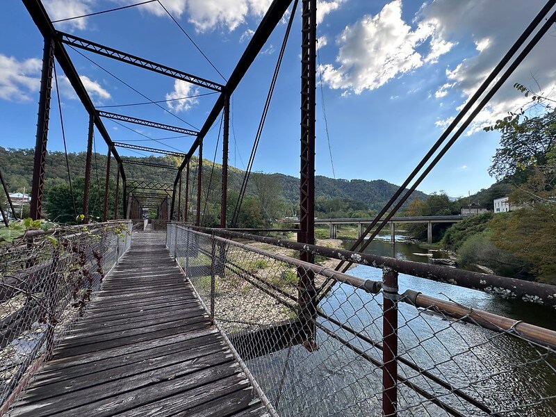
On a quiet morning in Elkhorn City the Russell Fork looks almost gentle. The river slides past sycamores and willows, the light catches on riffles below the cliffs, and coal trains roll along the far bank toward the Breaks. Beside the Elkhorn City Railroad Museum a rusted steel truss reaches out over the water, its deck long gone, its diagonal members clothed in kudzu and wind. For generations that bridge carried cars, school buses, and then walkers between town and the rail yard. Now it stands locked and empty, a piece of early twentieth century engineering slowly being reclaimed by vines and weather.
This is the story of that walk bridge and its twin, of how two iron crossings helped make a rail town on the edge of Kentucky and Virginia, and of how a community has tried to pull new life from old steel.
A river town on the edge of the Breaks
Elkhorn City grew up in a bend of the Russell Fork of the Big Sandy River near the mouth of Elkhorn Creek, in a narrow pocket where Pike County leans against the Virginia line. The modern city dates to 1912, when residents of the settlement that had been known by names like Elkhorn, Praise, and Cedarville incorporated as Elkhorn City, a railroad and coal town of barely a hundred people with big ambitions.
For all its promise, the river that made the town possible also hemmed it in. Before the bridges came, the Russell Fork was a barrier. The only crossings were rough fords that could be treacherous in high water. Rail lines could reach only the outskirts of town because there was no way to carry track across the stream. ExploreKYHistory’s entry on Elkhorn City’s railroads notes that the Chesapeake and Ohio Railway was in the area by 1906, yet its tracks stayed outside town until a railroad bridge went up in 1912.
The same year that Elkhorn City incorporated, the nation’s lawmakers turned their attention to that narrow river valley. In April 1912 Congress passed “An Act Authorizing the fiscal court of Pike County, Kentucky, to construct a bridge across Russell Fork of Big Sandy River,” giving the county permission to build, maintain, and operate a highway bridge at or near Elkhorn City under the federal bridge act of 1906. The law may look dry on paper, but on the ground it opened the way for a pair of projects that would tie the young city more firmly into the wider world.
Two iron crossings in a year of change
Local memory and later engineering surveys agree that 1912 became a turning point. In that year two major railroads, the C&O from the north and the Carolina, Clinchfield and Ohio from the south, finally met at Elkhorn City after a long push through the mountains. At almost the same time two steel highway bridges were built across the Russell Fork, one on each side of town.
Bridge historian Calvin Sneed calls 1912 “an important year” for the new city because those twin one lane steel truss bridges replaced dangerous fords and were soon folded into the route of Kentucky Highway 80, the main east west road in this corner of the state. The western crossing, today often called the Bridge Street Bridge or the west Elkhorn City Bridge, connected the business district to the rail yard and the mouth of Elkhorn Creek. The eastern bridge carried traffic toward the Breaks and the Virginia line.
HistoricBridges.org describes the western bridge as a three span pin connected through truss structure. The main channel span is an eight panel camelback through truss, flanked on each side by seven panel Pratt through truss approach spans. A builder’s plaque identifies the Champion Bridge Company of Wilmington, Ohio, and gives the construction date as 1912.
The eastern bridge, a short distance upstream, is similar but slightly longer. Bridges and Tunnels documents it as a multiple span structure with a nine panel camelback through truss over the main channel, a Pratt through truss approach, and a Pratt pony truss at one end. The available evidence suggests that Champion built this one as well, although its nameplate is gone.
Together the pair gave Elkhorn City something rare even for bridge rich eastern Kentucky. In a few tight river bends, motorists could cross two different multi span, pin connected through truss bridges, each with distinctive camelback silhouettes against the hills. HistoricBridges.org lists both as among the few surviving multi span pin connected truss crossings in Pike County and notes that the west bridge is a particularly important surviving example of Champion’s work.
Local lore adds another twist. According to Calvin Sneed’s interview with Larry Lounsberry, manager of the Elkhorn City Railroad Museum, the west bridge may have had a life before Elkhorn. Lounsberry recalled that Champion originally built the camelback span for the C&O at Catlettsburg on the Big Sandy, and that the railroad later recycled it upriver as a highway bridge for the new town. Whether or not every detail can be proved, the story captures something true about mountain infrastructure, where little is wasted and steel often travels as far as people do.
On the road as KY 80
Once the bridges were in place, they quickly became part of the daily rhythms of a growing coal and rail community. Both carried the alignment of Kentucky Route 80, the main east west highway through eastern Pike County, and both did so with only a single narrow lane of deck that required drivers to take turns crossing.
For decades the west bridge delivered travelers directly into the heart of town. On one side lay the business district and houses climbing the hillside. On the other side were coal tipples, the rail yard, and the tracks that led toward Pikeville in one direction and the Breaks gorge in the other. The east bridge anchored the opposite end of town and carried KY 80 traffic toward Virginia and the high country of Pine Mountain.
By the mid twentieth century, however, state highway engineers wanted wider, straighter, and safer roads. The west Bridge Street crossing was bypassed by a new bridge in 1950, shifting the main highway downstream. The east bridge remained in service longer but was replaced by a newer concrete structure in 1968.
Even after they lost their highway role, the old trusses did not immediately fall silent. Like many historic spans in small towns, they found second lives as local connectors and pedestrian routes. The west bridge in particular became a key footpath between downtown and the rail yard. Later, when the rail yard was transformed into the Elkhorn City Railroad Museum, that same rusty truss became the most direct way for visitors to walk from the museum to the riverfront and the rest of town.
The railroad bridge and a yard full of stories
The walk bridge’s importance cannot really be understood without the railroad it leads to. Just upriver from the highway crossings stands another steel span, the Russell Fork railroad bridge. Jamie in Wanderland’s account of the structure notes that it was completed in 1912 and that its opening finally allowed the C&O and the Clinchfield to meet at Elkhorn City.
ExploreKYHistory explains that before this crossing existed, tracks could only reach the outskirts of town, while afterward the city became a junction where east west and north south coal traffic could be handed off between railroads. A Clinchfield Railroad history site backs up that chronology and highlights Elkhorn City’s role as the northern terminus of the Clinchfield, with a yard that linked Kentucky coalfields to Atlantic ports.
The yard that once bustled with interchange traffic is where the Elkhorn City Railroad Museum now stands. The museum occupies a former coal company office and holds more than a thousand pieces of railroad memorabilia, including cabooses, motor cars, uniforms, and even a seat from a president’s private railcar. The museum tells stories of the C&O and Clinchfield, of the Santa Train that still rolls through with gifts each November, and of the men and women who spent lives working the yard, the line, and the mines.
From the deck of the old walk bridge, when it was still open, visitors could look up the Russell Fork at the rail bridge and the museum buildings and understand in a single glance how river, rail, and road all came together at this narrow bend.
Blue lines, native plants, and a new river walk
By the late 1990s and early 2000s Elkhorn City’s rail economy had faded, but local residents and partners from outside the region began to imagine different kinds of connections along the river. One of the most ambitious efforts was “Beneath Land and Water,” a multi year public art and planning project led by artists Suzanne Lacy, Yutaka Kobayashi, and Susan Leibovitz Steinman.
Project documentation describes how artists and residents designed a Blue Line Trail and related installations that would link the town’s streets and riverbanks while also drawing attention to flooding, stormwater, and native plants. The “blue line” itself traced the height of historic floodwaters through town and down to the river, reminding walkers of how high the Russell Fork can climb when it leaves its banks.
Local attorney and heritage leader Tim Belcher later wrote about the Elkhorn City River Walk, also called the Blue Line Trail, describing it as a fifteen minute path that starts at the cabooses and Wm. Ramey marker near the museum, passes through waterfront parks and overlooks beneath the old bridges, and gives views of the Russell Fork that residents hold dear.
American Trails honored Nina Aragon of the Elkhorn City Area Heritage Council for helping shepherd this trail work, noting how she helped transform public art ideas into concrete projects that connected town, river, and historic sites. An exhibition write up from Wave Hill in New York noted that Beneath Land and Water included creating a new Blue Line Trail walking route with a native flora and fauna park that filters stormwater before it reaches the river.
In this new vision the old west bridge was not just a relic. It was a centerpiece, a steel arc linking the museum, the Blue Line Trail, and the river walk. Photographs from HistoricBridges.org and rail fan galleries show the truss framing hikers on the deck, kayakers on the river below, and modern CSX trains slipping past the museum in the background.
Rust, kudzu, and a fight to save the walk bridge
Time and weather have not been kind to the old steel. High resolution photo galleries by Dave Michaels on HistoricBridges.org show serious section loss, missing deck planks, and heavy rust on pins, eyebars, and floorbeams. Flickr and other photo sets from the 2010s document encroaching vegetation and a sagging deck that make clear why officials have become wary of leaving the bridge open, even for foot traffic.
A 2021 opinion column in the Lexington Herald Leader captured the bittersweet sight for many visitors. Writer Larry Webster described how kudzu and time had “had their way” with the Elkhorn City bridge, wrapping the iron truss above what he called one of the most beautiful river stretches on earth. The piece treated the walk bridge as a symbol of both neglect and resilience in the mountains, where older infrastructure often remains in place long after funding and attention move elsewhere.
At the same time local people have not quietly accepted the idea that the bridge should simply vanish. Social media pages like “Save the Old Elkhorn City Walk Bridge” share photographs, memories, and worries about possible removal. Posts often point out that the bridge is more than a rusty frame. It is a key part of the town’s identity, a gateway to the museum, and a visible reminder of the 1912 moment when Elkhorn City became a full participant in the region’s highway network.
The bridge has also continued to show up in official planning documents, even as its status has grown precarious. Kentucky Transportation Cabinet highway plans from the 2010s list projects for improving Bridge Street and associated sidewalks in Elkhorn City, and a U.S. Fish and Wildlife Service catalog of biological opinions includes entries for a “Bridge Street Bridge Rehabilitation Project” and an “Elkhorn City Water Main Relocation Project,” both of which involved federal review of work near the crossing.
Meanwhile newer bridges have taken over the practical tasks the old trusses once handled. A modern concrete structure built downstream in the mid twentieth century and replaced in 2015, now named the Kelver and “Bumper Jack” Stiltner Bridge, carries KY 80 across the Russell Fork on the east side of town. From that span and from overlooks above the gorge, you can look back and still see the rusted silhouettes of the 1912 crossings framing the river and the museum.
Reading the bridges today
Stand on the riverbank near the railroad museum and look up at the west walk bridge. It is easy to see only decay: missing deck boards, rust streaks on the piers, vines threading the lattice. Yet each line of iron also carries stories that matter for understanding both Elkhorn City and the wider Appalachian region.
As engineering artifacts, the 1912 bridges are rare survivors. Pin connected multi span camelback and Pratt through trusses have largely disappeared from mainline highway service in the United States. The Champion Bridge Company examples at Elkhorn City represent an important stage in bridge design between the lighter iron spans of the nineteenth century and the heavier riveted and welded structures that followed.
As historical landmarks, they mark the moment when river barriers gave way to steel and when a young rail town stepped more firmly into regional networks of trade, travel, and labor. In the space of a year Elkhorn City gained a railroad bridge, two new highway bridges, incorporation papers, and a bustling yard that became a hub for coal moving between the central Appalachian fields and distant ports.
As part of the landscape, the bridges help tell a longer story of how mountain communities have tried to remake abandoned industrial spaces into public places. The Blue Line Trail and river walk show how residents, artists, and trail advocates have used the old crossings and river banks as classrooms for environmental stewardship and as stages for new kinds of tourism and recreation.
Finally, as a walk bridge leading to a modest museum, the west bridge stands at the intersection of local and national memory. The artifacts inside the Elkhorn City Railroad Museum tell about the Clinchfield and the C&O, about coal traffic and Santa Trains and the daily work of mountain railroaders. The bridge outside tells about how those stories are approached, literally and figuratively, how people cross from the present into the rail yard’s past.
A Crossing Worth Keeping
Many Appalachian towns have lost the iron work that once defined them. Truss bridges have been replaced by concrete girders, and the older structures have often been scrapped with little ceremony. Elkhorn City is unusual because so much of its early twentieth century bridge fabric still stands, even if fenced and in poor repair.
When you look at the walk bridge near the museum you see more than a decaying piece of infrastructure. You see the imprint of a 1912 act of Congress, the work of Ohio bridge builders and local laborers, the coal trains that rumbled across the nearby rail span, and the countless trips that schoolchildren and shift workers once took between town and yard. You see the efforts of artists and residents who painted blue lines, planted native gardens, and imagined new futures for a riverfront shaped by flood and industry.
Whether Elkhorn City can ultimately save and stabilize the old walk bridge is a question that will depend on money, engineering reports, and political will. What is already clear is that the bridge matters. It matters to the community that has rallied around it, to visitors who come to see where highways and railroads threaded the Russell Fork, and to anyone who wants to understand how Appalachia’s built environment carries memory.
For now the truss still stands at the edge of the river, rusted but upright, a patient witness to more than a century of crossings.
Sources & Further Reading
United States Congress. “An Act Authorizing the Fiscal Court of Pike County, Kentucky, to Construct a Bridge across Russell Fork of Big Sandy River.” United States Statutes at Large 37 (1912) 92. Washington, DC Government Printing Office, 1912. https://www.govinfo.gov/content/pkg/STATUTE-37/pdf/STATUTE-37-Pg92.pdf GovInfo
U.S. Geological Survey. Elkhorn City, KY–VA, Historical Map GeoPDF, 7.5×7.5, 1:24,000 Scale, 1954. Surveyed 1954, printed 1955. USGS Store. https://store.usgs.gov/product/863914 USGS Store
U.S. Geological Survey. Elkhorn City, KY–VA, 7.5-Minute Series (Topographic), 1:24,000 Scale, 1963. Historical Topographic Map GeoPDF. National Map. https://prd-tnm.s3.amazonaws.com/StagedProducts/Maps/HistoricalTopo/PDF/KY/24000/KY_Elkhorn%20City_803490_1963_24000_geo.pdf The National Map
U.S. Geological Survey. Elkhorn City, KY, 7.5-Minute US Topo Map, 1:24,000 Scale, 2022. Avenza Maps digital edition. https://store.avenza.com/products/elkhorn-city-ky-2022-24000-scale-united-states-geological-survey-map Avenza Maps
Kentucky Geological Survey. “KGS Mobile Geology Map Portal.” Interactive mapping interface showing Elkhorn City quadrangle, topography, and geology. https://kgs.uky.edu/kgsmap/mobile/kgsgeoserver/ Kentucky Geological Survey
Pastmaps. “Old Maps of Elkhorn City, Kentucky.” Pastmaps historical map portal for Elkhorn City and vicinity, including 1954 USGS quadrangle. https://pastmaps.com/explore/us/kentucky/pike-county/elkhorn-city Pastmaps: Maps for Historical Research
Pickatrail. “Elkhorn City, Kentucky 7.5 Minute Topo Map.” Downloadable USGS topographic quadrangle for Elkhorn City, 1:24,000 scale. https://www.pickatrail.com/topo-map/e/7.5×7.5/elkhorn-city-ky.html Pick A Trail
HistoricBridges.org. “Elkhorn City Bridge West (Bridge Street Bridge).” Detailed bridge profile with construction date, builder (Champion Bridge Company), structural type, and photo documentation. https://historicbridges.org/bridges/browser/?bridgebrowser=kentucky%2Felkhorncity%2F Historic Bridges
HistoricBridges.org. “Pike County, Kentucky.” County bridge list summarizing Elkhorn City Bridge West and Elkhorn City Bridge East as rare multi span pin connected through truss bridges. https://historicbridges.org/b_a_list.php?c=&ct=&pname=Pike+County%2C+Kentucky&ptype=county Historic Bridges
HistoricBridges.org. “HistoricBridges.org Bridge Locator Pike County.” Locator entry for Elkhorn Bridge Street (Old SR 80) and Elkhorn East End Russell Fork bridges with coordinates, status, and photos. https://historicbridges.org/b_h_fipsm.php?bsearch=21195 Historic Bridges
Bridgehunter.com. “Elkhorn Bridge Street (Old SR 80) Russell Fork Bridge.” Catalog entry for the camelback through truss highway bridge over the Russell Fork Big Sandy River on former KY 80. https://www.bridgehunter.com/bridge/45545 Bridge Hunter
Bridgehunter.com. “Elkhorn East End (Old SR 80) Russell Fork Bridge.” Catalog entry for the abandoned multi span camelback and Pratt through truss bridge over the Russell Fork on former KY 80. https://www.bridgehunter.com/bridge/45546 Bridge Hunter
Sneed, Calvin. “East and West Bridges, Elkhorn City, KY.” I Love Bridges and Tunnels, September 21, 2023. Narrative history and structural description of the twin 1912 one lane steel truss bridges carrying KY 80 across the Russell Fork. https://www.ilovebridgesandtunnels.com/east-and-west-bridges-elkhorn-city-ky I Love Bridges and Tunnels
Cahal, Sherman. “Elkhorn City Bridge (West).” Bridges & Tunnels, March 27, 2022. Overview of the 1912 Champion Bridge Company highway bridge, its bypass in 1950, and conversion to pedestrian use before closure. https://bridgestunnels.com/location/elkhorn-city-bridge-west/ Bridges and Tunnels
Bridgehunter.com. “Pike County, Kentucky.” County level index listing Elkhorn Bridge Street and Elkhorn East End Russell Fork bridges with brief descriptions, history, and status. https://www.bridgehunter.com/counties/21195 Bridge Hunter
Kentucky Historical Society. “Elkhorn City’s Railroads.” Kentucky Historical Marker 2130 description, Pine Street, Elkhorn City, Pike County. https://history.ky.gov/markers/elkhorn-citys-railroads Kentucky Historical Society
Martin, McKenzie. “Elkhorn City’s Railroads.” ExploreKYHistory marker entry, Kentucky Historical Society, item 558. https://explorekyhistory.ky.gov/items/show/558 Explore Kentucky History
Historical Marker Database. “Elkhorn City’s Railroads.” Marker 2130 entry describing the C&O and Clinchfield connection at Elkhorn City and its role as a coal and timber shipping point. https://www.hmdb.org/m.asp?m=89778 HMDB
Elkhorn City Railroad Museum. “Elkhorn City Railroad Museum.” Official museum homepage with visitor information and photos of the rail yard and bridges at Elkhorn City. https://elkhorncityrrm.tripod.com/
Suzanne Lacy, Yutaka Kobayashi, and Susan Leibovitz Steinman. “Beneath Land and Water: A Project for Elkhorn City (2000–2006).” Project documentation of a multi year public art and planning initiative that created the Blue Line Trail and riverfront installations in Elkhorn City. https://www.suzannelacy.com/beneath-land-and-water-a-project-for-elkhorn-city SUZANNE LACY
Lacy, Suzanne. “Beneath Land and Water: A Project for Elkhorn City Kentucky.” Five year project video documenting the Elkhorn City collaboration and the Blue Line Trail concept. Vimeo. https://vimeo.com/channels/483964/38545667 Vimeo
Belcher, Tim. “Elkhorn City Trail Town: The Elkhorn City River Walk and The Blue Line Trail.” Life in a Small Town Law Office (blog), April 2, 2013. Describes the route, public art, and interpretive elements of the river walk and Blue Line Trail. https://timbelcher.wordpress.com/2013/04/02/elkhorn-city-trail-town-the-elkhorn-city-river-walk-and-the-blue-line-trail/ Life in a Small Town Law Office
Wave Hill. “Remediate Re Vision Public Artists Engaging the Environment.” Exhibition press release highlighting Beneath Land & Water – A Project for Elkhorn City, Kentucky and the Blue Line Trail’s native flora and stormwater filtering functions. https://news.cision.com/wave-hill/r/remediate-re-vision–public-artists-engaging-the-environment%2Cg519164 Cision News
Creative Capital. “Suzanne Lacy – Beneath Land and Water: A Project for Elkhorn City.” Awardee index entry summarizing the public art and social practice project in Elkhorn City. https://creative-capital.org/awardee-index/page/20/ Creative Capital
American Trails. “Kentucky: Nina Aragon.” Trail advocacy award profile describing Nina Aragon’s role with the Elkhorn City Area Heritage Council and her work advancing the Blue Line Trail and related projects. https://www.americantrails.org/communications/awards/kentucky-nina-aragon americantrails.org
Author Note: Bridges like this one help me see how roads, rails, and rivers braided together to build Appalachian towns. I hope this piece gives you a reason to stand by the Russell Fork, look up at that rusting truss, and see more than just old steel.