Repurposed Appalachia Series – The Train Depot of Evarts
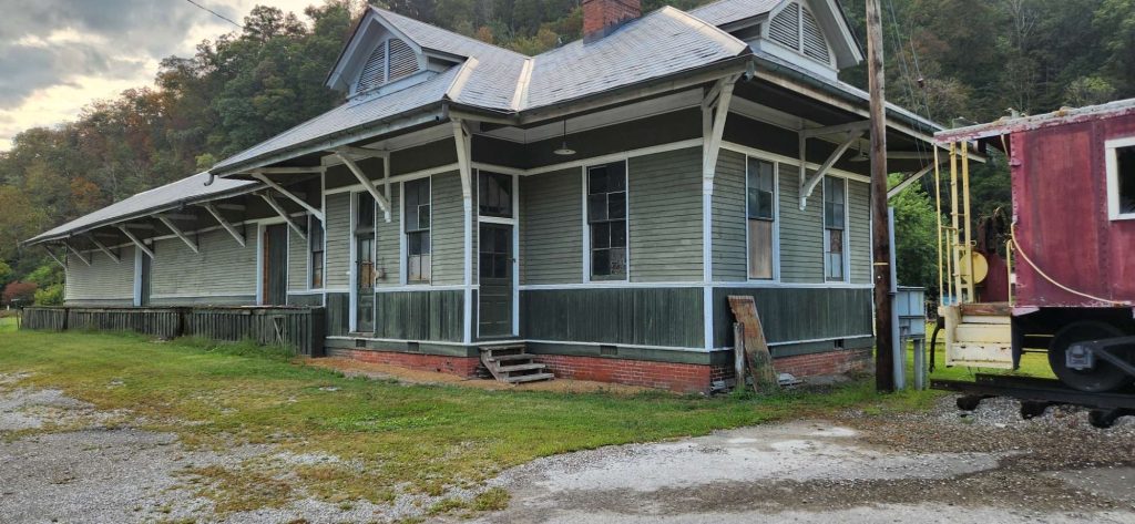
On a quiet day in Evarts it is easy to mistake the little frame depot for a simple photo backdrop. The paint is fresh, the roofline neat, and a caboose rests on a short section of rail that no longer goes anywhere. The building is small enough that you can step from one end to the other in a few strides. Yet for most of the twentieth century this was where the Clover Fork valley met the wider world, a place where miners caught trains, relief supplies were unloaded, and a coal town’s greatest hopes and worst fears gathered beside the tracks.
The Evarts train depot was part of the Louisville and Nashville Railroad’s Clover Fork Branch, a line that reached deep into Harlan County’s coal seams and made Evarts an end of track and a beginning of stories. It appears on mid century United States Geological Survey topographic maps as a modest node on the north side of town, with yard tracks curling around it between the highway and the river. It shows up again in a statewide inventory of historic railroad structures as a wood depot, built sometime between about 1900 and 1924, on the north side of Evarts and owned by the L and N. For miners, merchants, and families in the Clover Fork valley, that small building was the front door to the rest of the country.
A Small Depot at the End of the Line
When the Louisville and Nashville pushed its Harlan Branch up the Cumberland River and into Harlan in 1911, the company did not stop there. From the county seat the railroad followed Clover Fork and its tributaries toward new mines at Draper, Black Mountain, and Glenbrook. By the time the system settled into its mature form, Evarts sat as a terminal for the Clover Fork Branch, with tracks continuing further east only as industrial spurs into company coal camps.
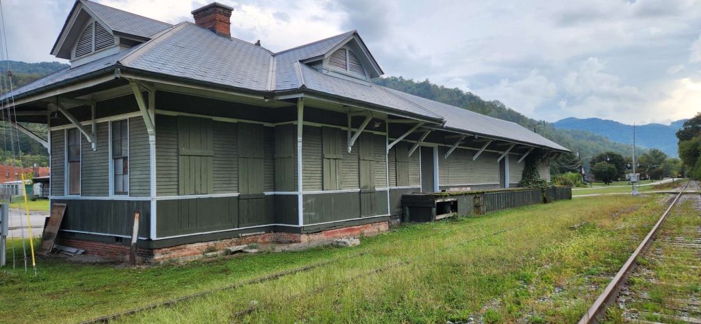
You can see how the railroad knitted itself into the town on the seven and a half minute Evarts quadrangle map. The depot is on the north side of the main track, roughly parallel to the river and the highway, with sidings fanning out around it. The geologic map of the Evarts quadrangle places the line and town fabric against the steeply folded rocks of Pine Mountain, a reminder that every ton of coal that passed the depot had to be wrestled from difficult ground.
A statewide railroad history and archaeology context prepared for the Kentucky Transportation Cabinet takes the story one step closer to the building itself. In a table of historic rail properties it notes a depot on the north side of Evarts, built sometime between 1900 and 1924 for the Louisville and Nashville. That range fits what the maps suggest. The L and N reached Harlan by 1911 and pushed east into the coal camps in the decade that followed. The Evarts depot belongs to that moment when industrial capital and timber crews were turning a creek valley into a rail served town.
The structure that survives today matches what you would expect from a small combination depot of that period. Photographs taken by rail enthusiasts and travelers show a one story frame building with wide eaves, deep overhangs to shelter passengers and freight, and a trackside elevation that once held bay windows or enlarged operator’s windows for watching the main line. A caboose sits nearby on a remnant of yard track, a visual reminder that Evarts was once more than a quiet town at the end of a dead line.
Coal, Relief, and Everyday Depot Life
For most of its working life the Evarts depot was a very practical place. L and N employee timetables from the mid twentieth century list Evarts as a station on the Corbin Division’s Clover Fork Branch, with mileposts, siding lengths, and train meets laid out in small type that meant everything to train crews and dispatchers. The branch brought in supplies and passengers and hauled out coal from the camps up Clover Fork and its side hollows.
The depot also mattered in smaller ways that rarely show up in company records. In his memoir Memory of a Miner: A True-Life Story from Harlan County’s Heyday, Michael Ruth recalls walking from the Draper area into Harlan and then on to Evarts to pick up commodities during the Depression. The depot and its platform were part of that errand. Relief flour, canned goods, and other shipments came by rail, and the station became a kind of doorway where outside aid crossed into the lives of valley families.
One particular relief story, told and retold in newspapers, illustrates how the depot could briefly sit at the center of a much larger narrative. In January 1932, during the worst years of the Depression, Harry and Leah Appleman arranged to give away a carload of flour at the Evarts depot. An article in the Indianapolis Times described the scene, noting how the couple invited “all needy from Evarts and surroundings” to come to the station. Later pieces in magazines such as Lilith and The Forward would quote that advertisement and use the giveaway to frame broader discussions of charity, Jewish life, and the coalfields.
Federal floodplain documents even manage to capture a snapshot of the depot’s relationship to its landscape. The 1980 Flood Insurance Study for the City of Evarts maps Clover Fork, the railroad embankment, and associated structures as part of its analysis of how high water would move through town. The study shows the tracks on slightly higher ground, emphasizing that the line and depot were not only economic lifelines but also physical features that shaped how floodwaters flowed.
The Battle of Evarts and the Railroad Yard
On May 5, 1931, the tracks near Evarts shifted from route of commerce to ground of conflict. That morning a short convoy of company cars and trucks carrying deputies and mine guards drove up the highway east from Harlan, past the depot and yard area on the edge of town, and into history. Strikers and their supporters were waiting near the road and railroad crossing outside Evarts. When the shooting stopped four men were dead, and what came to be called the Battle of Evarts had become the signature event of the early Harlan County mine wars.
Bill Bishop’s 1976 Southern Exposure article “1931: The Battle of Evarts” pieces together first hand accounts and Senate testimony to reconstruct that morning. Bishop describes strikers massing around the Evarts railway station and along the road, and he emphasizes how the independent town of Evarts, with its depot and non company housing, became a staging ground for miners evicted from company camps. John Hevener’s book Which Side Are You On? The Harlan County Coal Miners, 1931–1939 uses court records and witness statements to similar effect, locating the confrontation in the tangle of road, track, and river just outside the built up part of town.
Later historians have continued to rely on that geography. Carletta Bush’s dissertation on miner preachers and the United Mine Workers in southern Appalachia notes that on the morning of May 5 miners gathered along the highway and near the Evarts depot as they prepared to confront company forces. Ron Soodalter’s article “The Price of Coal” describes union men filling the railroad yard area, waiting as the company convoy approached.
The depot itself does not appear as a character in these narratives in the way a courthouse or company office might. It functions instead as a landmark. The station, the yard, and the road crossing fixed the place where the two groups collided. For a coal town, that was fitting. The depot was where different worlds met every day: local and outside, labor and management, coal camps and city markets. On May 5, 1931, that meeting turned deadly.
Maps, Inventories, and the Slow Coming of Abandonment
Long after the Battle of Evarts faded from headlines, the depot continued to appear in technical documents that were not written with storytelling in mind. Those records now help trace the building’s slow decline and eventual restoration.
A statewide abandoned railroad corridor inventory, commissioned in the early 2000s, counted more than 1,200 miles of disused rail lines across Kentucky and noted dozens of historic structures that still stood along them. The Evarts to Dizney corridor on the Clover Fork Branch appears there as one of the coal field segments where rail service had dwindled or ceased. In a related Kentucky Transportation Center report on abandoned corridors, the Evarts depot is described as a wood combination depot that was vacant and in need of repair when researchers walked the line, and Evarts is listed as a terminal on the old L and N system maps.
Those inventories grew out of a larger state effort to keep track of rail abandonments and to think about possible reuse of old rights of way as trails, utility corridors, or preserved historic features. The 2015 Kentucky Statewide Rail Plan notes the creation of a Kentucky Abandoned Railroad Corridor Inventory and explains how the Department for Local Government and the Kentucky Heritage Council monitor abandonments and historic rail structures. The Evarts depot’s inclusion in those efforts hints at how close the building came to being lost or forgotten.
At the same time, federal regulators were starting to formalize what had already happened on the ground. In 2019 CSX Transportation petitioned for a discontinuance of service exemption on its Clover Fork Branch in Harlan County, covering roughly milepost OWH 242.28 to 258.5, a segment that included Evarts. The notice in the Federal Register summarized the lack of recent traffic and explained that any remaining overhead freight could be rerouted to other lines. In legal terms the branch moved from lightly used to functionally dormant. On the landscape the rails and depot were already quiet.
Neglect, Railfans, and a Cleaned Up Station
Because the Evarts depot outlived the great age of coal and steam, there is an unusually rich photographic record of its later years. Railfans who chased the last heavy coal trains into Harlan County in the 1980s and 1990s often photographed the station, sometimes without even trying to make the building the main subject.
An article from the CSX Transportation Historical Society titled “Following a ‘Hilo’ in Harlan County” includes a sequence of images of train C821–21 working up the valley. In one frame the train is passing the “old L and N depot at Evarts.” The author notes that after years of neglect some repairs had been made to the north end of the building and speculates that it was under lease or private ownership, while also recalling that L and N once maintained two or three storage tracks along the depot’s side of the main.
By the mid 2000s and 2010s other photographers were capturing a very different look. A 2011 image on Flickr shows the Evarts depot freshly painted, with refurbished siding, new roofing, and a caboose placed on a short stub track beside it. The caption identifies the scene simply as “Evarts Train Depot,” but the visual message is clear. The building has been stabilized and restored, even if the rails around it no longer lead to active mines.
A short field note on the Tunnel Diaries blog from 2016 calls the structure a “refurbished train station at Evarts KY” and remarks that “it cleaned up quite nicely,” pairing that observation with two photographs that show the depot and caboose in context. The author adds a bit of town history, noting that Evarts’ first post office opened in 1855 and speculating that the railroad reached the town soon after the L and N came into Harlan in 1911.
Tourism and local history materials produced in Harlan County now often feature the depot alongside other historic sites. County level bibliographies compiled by Pine Mountain Settlement School point researchers toward flood studies, economic reports, and photographic collections that include views of Evarts and its rail corridor. The depot has shifted from being a working piece of infrastructure to being a backdrop for heritage tourism, community events, and personal memory.
Voices from Evarts and the Railroad District
If the maps and technical reports tell you where the Evarts depot stood and how the railroad ran, the oral histories tell you what it felt like to live with it. The Louie B. Nunn Center for Oral History at the University of Kentucky maintains an “Evarts, Kentucky Oral History Project” that gathers interviews with residents about the town’s history over the twentieth century. Transcripts in that collection include recollections of walking the tracks, living near the yard, and using the depot area as a navigation point when everything in town seemed oriented toward the railroad.
Those local memories echo the broader stories recorded by Alessandro Portelli in They Say in Harlan County. Portelli’s interviews are not focused solely on Evarts, but the town and its rail line appear again and again as miners describe moving between camps, towns, and picket lines. In that sense the depot is always just offstage. It is the place where people caught the train to a union meeting or watched a load of coal roll by on its way to market.
Together these voices make clear that the depot was never only a box on a map or a line in a budget bill. It was part of the everyday geography of the Clover Fork valley. Children walked past it on their way to school. Women and men waited under its eaves for news, mail, and visitors. Strikers and deputies eyed each other near its platforms in 1931. Long after the last scheduled train left, the building remained a landmark that told people where they were.
Why the Evarts Depot Matters
Today the Evarts depot stands at the intersection of several overlapping histories. It is a physical relic of the L and N’s Coal Age expansion into Harlan County. It is a silent witness to the Battle of Evarts and to the longer struggle over coal, unionism, and power in the county. It is a case study in how modest rail structures move from active service to abandonment on paper to partial restoration as symbols in tourism brochures.
For researchers and family historians, the depot also offers a way to tether personal stories to physical space. A line in a memoir about walking to the Evarts station for flour, a family story about relatives who arrived in the valley by train, or an oral history reference to “down by the depot” can now be triangulated with USGS maps, flood studies, and state inventories. That combination of lived memory and technical record helps turn a simple building into a three dimensional setting where Appalachian history unfolded.
Standing in front of the restored depot today, you can still hear the echo of that older world if you know what to listen for. The yard tracks are gone or rusted. The timetable is no longer pinned inside. The only cars beside the platform may be pickup trucks, not coal hoppers. Yet the building’s long narrow form, its placement between river and road, and its layered stories remind you that Evarts once sat at the very edge of a network that reached from a narrow Harlan County valley to Atlantic ports and Midwestern markets.
The Evarts train depot is small, but it holds the weight of coal cars, the footsteps of strikers, and the quiet of a town that has outlived the railroad that helped build it. In the boards and beams of that little station, you can still read the history of a community that learned how to live at the end of the line.
Sources & Further Reading
Brown, Carol E., William M. Eclov, Jerry W. Pigman, and Ronald G. Schmid. Abandoned Railroad Corridors in Kentucky. Research Report KTC-06-12. Lexington: Kentucky Transportation Center, College of Engineering, University of Kentucky, 2006. https://uknowledge.uky.edu/ktc_researchreports/ UKnowledge+1
Kentucky Transportation Cabinet. Kentucky Abandoned Railroad Corridor Inventory. Frankfort: Kentucky Transportation Cabinet, c. 2019. https://transportation.ky.gov/Railroads Kentucky Transportation Cabinet
Kentucky Transportation Cabinet, Office of Archaeology. A Context of the Railroad Industry in Clark County, Kentucky, and a General Rail History of Kentucky. Frankfort: Kentucky Transportation Cabinet, 2016. https://transportation.ky.gov/Archaeology Kentucky Transportation Cabinet
U.S. Geological Survey. Evarts, Kentucky–Virginia [Topographic Map, 7.5-Minute Series]. Washington, DC: U.S. Geological Survey, 1954; photorevised 1979. https://www.usgs.gov
U.S. Geological Survey. Geologic Map of the Evarts Quadrangle and Part of the Hubbard Springs Quadrangle, Kentucky–Virginia (GQ-914). Washington, DC: U.S. Geological Survey, 1974. https://pubs.usgs.gov
Kentucky Geological Survey. “Kentucky Raster Graphic (KRG) Dataset: Evarts Quadrangle Metadata.” Lexington: Kentucky Geological Survey, University of Kentucky. https://www.uky.edu/KGS CSX Transportation Historical Society
Federal Emergency Management Agency. Flood Insurance Study: City of Evarts, Harlan County, Kentucky. Washington, DC: Federal Emergency Management Agency, 1980. https://www.fema.gov Wikimedia Commons+1
Federal Register. “CSX Transportation, Inc.—Discontinuance of Service Exemption—in Harlan County, KY.” Federal Register 84, no. 188 (September 27, 2019): 51199–51201. https://www.federalregister.gov facebook.com
Kentucky General Assembly. House Bill 1, First Extraordinary Session 2002. Appropriations act including line item “Evarts Train Depot – Renovation of Building.” Frankfort: Kentucky Legislative Research Commission, 2002. https://apps.legislature.ky.gov/record/02ss/HB1/bill.doc Legislative Research Commission+1
Kentucky General Assembly. House Bill 269, Regular Session 2003. Appropriations act including funding for “Evarts Train Depot – Renovation of Building.” Frankfort: Kentucky Legislative Research Commission, 2003. https://apps.legislature.ky.gov/record/03rs/HB269/HCS2.doc Legislative Research Commission+1
Jimmy Emerson, DVM. “Evarts Train Depot, Evarts, Kentucky.” Photograph, taken February 12, 2011. Flickr. https://www.flickr.com/photos/auvet/5458887969 Flickr
Anderson, Bill. “Evarts Kentucky Train Depot.” Photograph. DeviantArt. https://www.deviantart.com/billndrsn/art/Evarts-Kentucky-Train-Depot-283405888 DeviantArt+1
“Abandoned Tracks at Evarts, Kentucky at an Old L&N Train Depot.” Photograph post in Abandoned Rails Facebook group, October 24, 2025. https://www.facebook.com/groups/abandonedrails/posts/1882356248464548 facebook.com
Ruth, Michael W. Memory of a Miner: A True-Life Story from Harlan County’s Heyday. Lexington, KY: Growth Resources, 2014. https://www.memoryofaminer.com Amazon+1
Ruth, Michael W. “Book Excerpt: ‘Memory of a Miner.’” AppalachianHistory.net, October 15, 2014. https://www.appalachianhistory.net/2014/10/book-excerpt-memory-miner.html Appalachian History
Portelli, Alessandro. They Say in Harlan County: An Oral History. New York: Oxford University Press, 2011. https://global.oup.com/academic/product/they-say-in-harlan-county-9780199735686 Amazon+1
Louie B. Nunn Center for Oral History. “Evarts, Kentucky Oral History Project.” University of Kentucky Libraries. https://kentuckyoralhistory.org/ The National Map
Indianapolis Times. “[Article on Harry and Leah Appleman Flour Giveaway at Evarts Depot].” January 6, 1932, 2. Accessed via Hoosier State Chronicles Digital Newspaper Program. https://newspapers.library.in.gov
Bernstein, Maya. “Kentucky Coal Mine Bubbe.” Lilith, March 17, 2005. https://lilith.org/articles/kentucky-coal-mine-bubbe Lilith Magazine+1
Nathan-Kazis, Josh. “Which Side Were We On? Kentucky Slavery, Mine Wars and Segregation.” The Forward, June 28, 2015. https://forward.com/culture/310910/which-side-were-we-on-kentucky-slavery-mine-wars-and-segregation The Forward+1
Bishop, Bill. “1931: The Battle of Evarts.” Southern Exposure 4, no. 1–2 (June 1976). Reprinted at Facing South, March 9, 2023. https://www.facingsouth.org/1931-battle-evarts Facing South+1
Hevener, John W. Which Side Are You On? The Harlan County Coal Miners, 1931–1939. Urbana: University of Illinois Press, 1978. https://www.press.uillinois.edu/books/?id=p073491 Cambridge University Press & Assessment+1
Bush, Carletta A. Faith, Power, and Conflict: Miner Preachers and the United Mine Workers of America in the Harlan County Mine Wars, 1931–1939. PhD diss., West Virginia University, 2006. https://researchrepository.wvu.edu/etd/2503 Research Repository+1
Soodalter, Ron. “The Price of Coal, Part I: Bloody Harlan and the Coal War of the 1930s.” Kentucky Monthly, September 30, 2016. http://www.kentuckymonthly.com/culture/history/the-price-of-coal kentuckymonthly.com+1
“Battle of Evarts.” Justapedia. https://justapedia.org/wiki/Battle_of_Evarts Justapedia+1
Lawrence, Bob. “Evarts KY.” The Tunnel Diaries (blog), February 12, 2016. https://thetunneldiaries.com/2016/02/12/evarts-ky Blogging the Railroad Tunnels+1
Pine Mountain Settlement School. “Harlan County Bibliography.” Pine Mountain Settlement School Collections. https://pinemountainsettlement.net Federal Register+1
Harlan County Tourism. “25 Historic Stops in Harlan County.” Harlan County Tourism. https://harlancountytrails.com Federal Register
National Archives and Records Administration. “Photographs of the Medical Survey of the Bituminous Coal Industry, 1946–1947 (Evarts, Harlan County, Kentucky).” U.S. National Archives Series. https://commons.wikimedia.org/wiki/Commons:National_Archives_and_Records_Administration/Categorize/US_National_Archives_series:_Photographs_of_the_Medical_Survey_of_the_Bituminous_Coal_Industry,_compiled_1946_-_1947 Wikimedia Commons
“Harlan County, Kentucky Topographic Maps & Elevations (Including Evarts).” AnyPlaceAmerica. https://www.anyplaceamerica.com/directory/ky/harlan-county-21095 anyplaceamerica.com
Author Note: As you read this piece, I hope you will picture the Evarts depot as more than a simple photo backdrop. It is a small surviving witness to coal, conflict, and community change, and I encourage you to visit respectfully and imagine the trains that once filled this valley.