Abandoned Appalachia Series – The Twin Tunnels of Typo and Yerkes of Perry County
On the north side of Hazard, the North Fork of the Kentucky River bends through a narrow valley where the slopes are so steep that the railroad disappears straight into the rock. Trains slip in and out of the hills, light fading to black and back again in a few seconds. Locals talk about “the twin tunnels” and about Typo and Yerkes in the same breath, a stretch of track where coal, river, and road have been crowded together for more than a century.
On a modern map the place is a tangle of names. USGS topographic sheets for the Krypton quadrangle label Typo, Yerkes, Dunraven, and Krypton along the river, with the railroad line and its tunnels threaded through the bends. The same maps show how the line hugs the base of the slope and dives into the hill twice in quick succession between Yerkes and Typo, one of the tightest pieces of railroad geography in Perry County.
Kentucky Landforms, drawing from the federal GNIS database, lists both Typo Tunnel and Yerkes Tunnel as railroad tunnels bored through the Hyden Formation, a mix of sandstone, siltstone, shale, underclay, and coal. That is the same rock that underlies many coal seams along the North Fork. In other words, the same geology that made the corridor valuable for mining also forced the railroad to burrow into the hill in order to stay close to the river and avoid steeper grades.
A coal camp at the tunnel’s mouth
Typo itself began as a river and railroad place before it ever became a tunnel road address. Early twentieth century railroad and mining maps put the Typo station at the mouth of First Creek, roughly five and a half miles by rail from Hazard, with a cluster of coal operations reaching up the side hollows. The community’s name has puzzled outsiders for decades. A modern encyclopedia entry notes that Typo’s origin story is hazy, possibly tied to loggers who lashed poles to their logs to make rafts at the mouth of Big Creek and floated them downriver. Whatever its exact origin, “Typo” became one of those names that turns up on lists of unusual American place names, a coal camp that sounded like a printer’s error but was very real to the people who lived there.
By the early twentieth century Typo had a post office, mines working up First Creek, and a station on the Louisville and Nashville Railroad’s Eastern Kentucky Subdivision. The post office would eventually close in 1913, but the rail line remained, and with it the steady traffic of coal trains running between the North Fork camps and the outside world.
In the twenty first century, photographs from the Lexington Herald-Leader’s archives show a coal train threading past houses on Typo Tunnel Lane, with the caption explaining that Typo is a former coal camp located off Kentucky 15 a few miles north of Hazard. In those images, houses and gardens sit only a few steps from the rails, a reminder of how intimately coal towns were built around the line.
Carving the railroad through the North Fork valley
The twin tunnels make more sense when they are seen as part of the larger Eastern Kentucky Subdivision, the L&N route that tied Hazard and the North Fork coalfield to the rest of the system. Railroad historian Kincaid A. Herr’s corporate history of the Louisville and Nashville describes how, in the early twentieth century, the company pushed branches and new main lines into eastern Kentucky to reach bituminous coal. One of those pushes followed the North Fork, using the river’s narrow valley as a natural path even when the curves and cliffs made construction difficult.
An article in Railway Signaling and Communications from 1950, written when the line was already a mature coal hauler, describes Centralized Traffic Control being extended on the “EK” between Combs and Typo. The text makes clear that this railroad served “extensive bituminous coal fields” in Perry and Letcher Counties and lists the branches feeding it, including the Lots Creek, Carrs Fork, and Leatherwood branches. It is a technical article about signals, relays, and control machines, but between the lines it shows a railroad busy enough to warrant modern signaling.
By mid century, the stretch between Hazard, Yerkes, and Typo was part of a through route that carried loaded coal trains out toward Winchester and beyond. A federal environmental impact statement written in the early 2000s still described a roughly 123 mile freight line between Winchester and Typo, owned and operated by CSX and averaging more than a dozen trains a day at that time.
The tunnels at Typo and Yerkes were engineering responses to a simple problem. The river cuts sharply into the hills, and the valley wall is too steep to climb without costly grades and trestles. Tunnels allowed the track to maintain a workable profile while staying close to the river and the coal camps strung along its banks. USGS topographic maps of the Krypton quadrangle from the mid twentieth century onward show those tunnels in place, tight curves drawn in brown contour and black track lines where the railroad slips in and out of the mountain.
The twin tunnels on the map
On paper, Typo Tunnel and Yerkes Tunnel are separate entries. Kentucky Landforms lists Typo Tunnel as a railroad tunnel owned by the L&N, with coordinates that place it along the river near the Typo station site, cut through Hyden Formation rock. Yerkes Tunnel appears the same way, another L&N railroad tunnel, also in the Hyden Formation, a little farther up the valley.
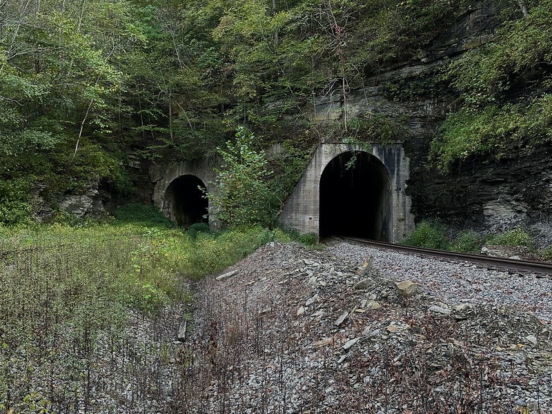
The same database goes further, listing separate features for Typo Tunnel No. 1 and Typo Tunnel No. 2 at their east and west ends, and multiple portal entries for Yerkes Tunnel. This bureaucratic way of describing the land hints at a physical reality that is easier to see on railroad photographs than in a table: paired bores cut side by side, one for each track or one a newer replacement, depending on the era.
AnyplaceAmerica’s feature card for Typo Tunnel confirms that it is shown on the Krypton US Topo map and places it only a short distance from the historic Typo railroad station and First Creek, reinforcing the connection between the tunnel, the camp, and the line.
Today, the best visual proof of the twin tunnels comes from cameras rather than contour lines. The CSX Transportation Historical Society hosts a photograph that explicitly identifies “South portals of CSX Yerkes Tunnels,” showing two bores side by side in a steep hillside, the track curving through a cut and past the portals. Railfan photographer Dan Bourque’s Appalachian Railroad Modeling site adds further images from the 1980s, with Seaboard System locomotives emerging from the north and south Typo tunnels, coal trains pushing hard up the grade.
Those photographs match what the maps and landform databases are telling us. Between Hazard and Krypton, there is a piece of railroad where the line dives in and out of the mountain through more than one bore, a place where twin portals stand almost shoulder to shoulder. Local vocabulary reflects that. A popular geocache listing titled simply “Twin Tunnels” describes tunnels built in the early 1920s with “interesting architecture for that time period” and warns that coal trains still pass through them regularly, urging visitors to stay off the right of way.
On Flickr, a recent album labeled “Yerkes Twin Train Tunnels” gathers dozens of photographs of both portals, interiors, drainage ditches, and nearby slopes. The images are modern, with welded rail, ballast shoulders, and CSX warning signs, reminders that this is not an abandoned place even when the surrounding camp feels quiet.
A tunnel road at the edge of town
If the tunnels define the railroad side of the story, Typo Tunnel Road and Typo Tunnel Lane mark the same country in the language of roads and addresses. Kentucky’s official road listings describe Kentucky Route 267 as a rural secondary route whose state maintenance begins at Typo Tunnel Road, also known as County Road 1304A, in Typo. Contract documents for a 2010 resurfacing project put it plainly: “TYPO-CLEMONS-HARVEYTON-LOST CREEK ROAD (KY 267) FROM TYPO TUNNEL ROAD (CR 1304A)” with coordinates and milepoints spelled out for engineers and contractors.
Property listings and tax records attach a string of house numbers to Typo Tunnel Lane, mapping a small cluster of homes and farmsteads along the river and close to the track. From the outside, these look like ordinary real estate entries, but they echo what the news photographs already showed: the tunnel is not some remote curiosity off in the woods. It is next to someone’s yard, a landmark that became a road name and then a mailing address.
For residents, “Typo Tunnel Road” is also a point of reference in times of danger. During the catastrophic July 2022 floods in Eastern Kentucky, the City of Hazard used social media updates to collect information on blocked roads and missing residents; one evening post specifically asked for information about conditions on Typo Tunnel Road as search and rescue continued.
Brush fires have come close as well. A post from a local outlet warned motorists to use caution on Typo Tunnel Road due to a fire threatening a nearby home, noting that Hazard firefighters were responding. In these small emergency notices, the tunnel name appears again, not as a curiosity on a map but as a place where people live and where weather and fire carry real risk.
Coal trains, signals, and a changing line
Operationally, the twin tunnels sit on what has long been a coal-hauling railroad. The 1950 Centralized Traffic Control article that covered the Combs to Typo project described a line fed by numerous coal branches, many of them household names in Perry County: Lots Creek at Hazard, the Leatherwood branch, and others.
Later, the line passed from L&N to Seaboard System and then CSX, but its role remained much the same. A 2002 federal study of a proposed power project still described the Winchester to Typo line segment as carrying more than a dozen freight trains a day, evidence that this was not simply a remnant branch but an active freight corridor.
Railfan guides like Robert D. Vaughn’s “Guide to Appalachian Coal Hauling Railroads, Volume 3b” treat the Eastern Kentucky Subdivision as a system where one can follow trains from Ravenna to Hazard, with specific notes on where to turn off Highway 451 at Yerkes to view trains at the Typo and Yerkes tunnels. Those guides, and the railfan sites that quote and extend them, confirm the importance of this short stretch of track for people fascinated by coal railroading.
Modern hobbyist resources keep track of the subdivision in more technical ways. The Radioreference wiki, for example, lists mileposts, radio frequencies, and detector locations on the CSX Eastern Kentucky Subdivision, explicitly naming Yerkes and Hazard among the key points. The presence of a trackside defect detector at Yerkes into the twenty first century is another quiet proof that the line here has remained part of an operating railroad, even as coal traffic across the region has declined.
At the same time, some sections of the old Eastern Kentucky Sub north of this area have seen service reduced or suspended, and Kentucky Transportation Cabinet reports on abandoned corridors show how quickly coal-era track can disappear once traffic stops. That context makes the twin tunnels between Typo and Yerkes feel even more like survivors, pieces of a once larger coal railroad that still echo with the sound of locomotives.
Geology, water, and risk in the tunnel valley
From a geologist’s perspective, the twin tunnels tell a story about rock and water as much as they do about coal. The Hyden Formation that Kentucky Landforms lists as the host rock for both Typo and Yerkes tunnels is a layered sequence that mixes sandstone ledges with softer shale, underclay, and coal seams. The sandstone provides the strength that allows a tunnel to stand, but the weaker layers and coal seams above and below can channel groundwater and create instability when exposed.
Geologic mapping of the Krypton quadrangle by the USGS and Kentucky Geological Survey places these tunnels within a broader pattern of folded and faulted strata along the North Fork. The railroad builders chose their tunnel sites carefully, threading the line through rock that would hold an arch but also lining and supporting it where necessary.
In the twenty first century, the biggest challenge for the valley has come not from the rock but from water. Between July 25 and July 30, 2022, a series of training thunderstorms produced rainfall rates of more than four inches an hour over portions of eastern Kentucky, including Perry County. The resulting flash floods killed dozens of people, destroyed homes, and washed out roads and small bridges across the region. News coverage and later studies noted how surface mining and narrow valley development had amplified the damage.
In that context, a place like Typo Tunnel Lane becomes more than a quirky address. Houses built between river, road, and track are on narrow benches that leave little room for water to spread out safely. Emergency calls asking about the condition of Typo Tunnel Road during the flood were not simply about transportation; they were about whether people in the tunnel valley could get out or be reached.
Visiting the twin tunnels today
For people who love maps and railroads, there is a powerful urge to go stand where the lines on the page and the photographs come together. Road directions from railfan guides point travelers out of Hazard along Kentucky 15 and then along Kentucky 451 and local roads, noting where to turn to see trains entering or leaving the twin bores.
The geocache listing for “Twin Tunnels” captures both the attraction and the risk. The author provides coordinates for a good distant view and adds a clear warning not to go near the tunnels or the track because coal trains still use the line. Modern images from Flickr and social media repeat the same theme, showing visitors posing at safe distances, photographing the portals, or watching trains from public crossings and pull offs.
For anyone who goes, the safest way to see the tunnels is from those kinds of public vantage points, respecting private property, the danger of active railroad tracks, and the fragile slopes below the portals. Floods, brush fires, and rockfall are part of the story here, just as much as coal and locomotives.
Why the twin tunnels matter
Viewed on a single map sheet, the twin tunnels of Typo and Yerkes are just two short dark lines in a field of contour curves. On the ground they take shape as a specific place: a bend in the North Fork where a coal railroad and a coal camp crowded into the same narrow notch, where houses were built almost on top of the track, and where people still live with trains and high water close at hand.
They also sit at the crossroads of several kinds of Appalachian history. At one level they are pieces of industrial engineering, part of the Louisville and Nashville’s larger campaign to reach and ship eastern Kentucky coal, preserved in corporate histories, signaling journals, and railroad plans in the Filson Historical Society’s archives. At another level they are part of the lived landscape of Perry County, appearing in county road lists, real estate deeds, wildfire reports, and social media flood updates.
Finally, they exist in memory and imagination. Sulzer’s Ghost Railroads of Kentucky, with its chapter “Up North Fork Way,” and more recent abandoned corridor inventories remind us how many similar lines have already vanished, leaving only faint grades and empty cuts. The fact that trains still enter and leave these twin tunnels gives them a different kind of ghostliness. They are relics of a coal age that is passing, yet they are still in service, still shaking the ground, still a point where the long story of Appalachian railroading runs on into the present.
For a historian walking the right of way from a distance, or tracing the line on a Krypton quadrangle sheet at a desk, the tunnels anchor a whole story. They tie together Typo’s coal camp, Yerkes’s river bend, the Hyden Formation in the hills above, and the larger arc of the Eastern Kentucky Subdivision. In a county full of hollows and creekside settlements, they give one more way to see how people, rock, and steel have shaped each other along the North Fork of the Kentucky River.
Sources & Further Reading
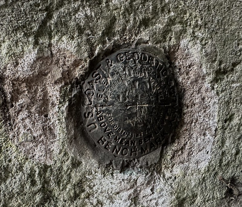
U.S. Geological Survey. Results of Spirit Leveling in Kentucky, 1898 to 1913, Inclusive. Bulletin 554. Washington, DC: Government Printing Office, 1914. https://pubs.usgs.gov/publication/b554
U.S. Geological Survey. Krypton, Kentucky [topographic map]. 7.5-minute series, scale 1:24,000. Washington, DC: U.S. Geological Survey, 1961. GeoPDF, Historical Topographic Map Collection. https://prd tnm.s3.amazonaws.com/StagedProducts/Maps/HistoricalTopo/PDF/KY/24000/KY_Krypton_709037_1961_24000_geo.pdf
U.S. Geological Survey. Hazard, Kentucky [topographic map]. 30 x 60 minute series, scale 1:100,000. Reston, VA: U.S. Geological Survey, 1977. GeoPDF, Historical Topographic Map Collection. https://prd-tnm.s3.amazonaws.com/StagedProducts/Maps/HistoricalTopo/PDF/KY/100000/KY_Hazard_710071_1977_100000_geo.pdf
“Stacy Branch, KY, Krypton 7.5′ Quadrangle Map View.” TopoQuest. Accessed January 1, 2026. https://topoquest.com/map.php coord=d&datum=nad27&lat=37.26232&lon=-83.29796&map=24k&mode=zoomout&size=l&zoom=16
“Typo Tunnel Topo Map in Perry County, Kentucky.” AnyPlaceAmerica. Accessed January 1, 2026. https://www.anyplaceamerica.com/directory/ky/perry-county-21193/tunnels/typo-tunnel-516092/
“Map and Download 2381 Land Features in Kentucky to Your GPS.” ExpertGPS. Accessed January 1, 2026. https://www.expertgps.com/data/ky/land-features.asp
Classic USGS Krypton Kentucky 7.5′ x 7.5′ Topo Map. MyTopo Map Store. Accessed January 1, 2026. https://mapstore.mytopo.com/products/historic_7-5×7-5_krypton_kentucky
“Kentucky Topographic Index Maps: 1:100,000.” YellowMaps. Accessed January 1, 2026. https://www.yellowmaps.com/usgs/state-index-maps/topo-KY.htm
Historic Resources Survey, Exhibit G, Bright Mountain Solar Project, Perry County, Kentucky. Prepared for the Kentucky Public Service Commission in Case 2022-00274, filed 2024. Accessed January 1, 2026. https://psc.ky.gov/pscecf/2022 00274/ssheely%40bricker.com/02192024065221/Exhibit_G_Historical_Resources_Survey.pdf
“CSX – EK SD, 11 05 and 11 13 2015.” CSX Transportation Historical Society, Rail Fanning section. Accessed January 1, 2026. https://www.csxthsociety.org/railfanning/csxeksd2015-11-05n13.html
“Viewing Album: CSX In The Coalfields.” RRPictureArchives.net. Accessed January 1, 2026. https://m.rrpicturearchives.net/archiveThumbs.aspx?Page=3&id=9755
“CSX 45 – Yerkes, KY.” RRPictureArchives.net. Accessed January 1, 2026. https://www.rrpicturearchives.net/locopicture.aspx?id=34293
“Twin Train Tunnels in Hazard KY 2 More Tunnels Down Yerkeys KY.” YouTube video, 26:29, posted by Jd Beatty’s Adventure’s. Accessed January 1, 2026. https://www.youtube.com/watch?v=6DX7jRTTMY4
“Twin Train Tunnels Hazard KY.” YouTube video, posted by Jd Beatty’s Adventure’s. Accessed January 1, 2026. https://www.youtube.com/watch?v=IpRvjDMdQ6w
“Train Tunnels and an Old Abandoned Park in Perry County Kentucky.” YouTube video. Accessed January 1, 2026. https://www.youtube.com/watch?v=p3t5sWOfDhs
“Hazard, Heart of the Coal Fields.” Pine Mountain Settlement School, Local History Scrapbook, 1920–1980. Accessed January 1, 2026. https://pinemountainsettlement.net/scrapbooks-albums-gathered-notes/scrapbooks/guide-local-history-scrapbook-1920-1980/hazard-heart-of-the-coal-fields/
“Eastern Kentucky Coal Field – Perry County.” Kentucky Coal Education. Accessed January 1, 2026. https://www.coaleducation.org/coalhistory/coaltowns/perry.htm
“Perry County Fiscal Court – Perry County, Kentucky.” Perry County Fiscal Court. Accessed January 1, 2026. https://perrycounty.ky.gov/pages/default.aspx
“Overview – Perry County, Kentucky.” Perry County Fiscal Court. Accessed January 1, 2026. https://perrycounty.ky.gov/da/Pages/default.aspx
“Guide to Appalachian Coal Hauling Railroads, Volume 3B – CSX’s Eastern Kentucky Subdivision, Ravenna to Hazard.” Spike Systems. Accessed January 1, 2026. https://www.spikesys.com/Trains/App_coal/apcl_3b.html
“EK Sub.” RadioReference Wiki. Entry for CSX Eastern Kentucky Subdivision. Accessed January 1, 2026. https://wiki.radioreference.com/index.php/EK_Sub
“Yerkes, Kentucky.” Wikipedia. Accessed January 1, 2026. https://en.wikipedia.org/wiki/Yerkes,_Kentucky
“Kentucky Route 451.” Wikipedia. Accessed January 1, 2026. https://en.wikipedia.org/wiki/Kentucky_Route_451
“Perry County KY Coal Miners Deaths.” Genealogy.com forum post by Lynita King. Accessed January 1, 2026. https://www.genealogy.com/forum/surnames/topics/marinich/1/
“Photos or Stories of Blue Diamond Coal Co. in Hazard?” Facebook group post in “Appalachian Americans.” Accessed January 1, 2026. https://www.facebook.com/groups/300999108219027/posts/520148069637462/
Author Note: I grew up in a part of eastern Kentucky where coal trains and river bends quietly shaped the backdrop of everyday life, so standing in sight of the Yerkes twin tunnels feels like stepping inside that familiar landscape. I hope this piece helps you see these tunnels not just as concrete and steel, but as a living thread in Perry County’s story.