Abandoned Appalachia Series – Baxter Bridge of Harlan County
If you stand at the Baxter Coal Monument and look toward the river, a narrow lattice of riveted steel still rises above the trees. That is Baxter Bridge, a Baltimore through truss that once carried U.S. 119 over the Cumberland River’s forks and now hangs quiet over the reengineered channel and floodplain. Historic survey work and modern documentation let us tell the story of how this hundred year old span fit into Harlan County’s road network, why it was left behind, and why people still care about it today.
This article leans first on primary material: Kentucky Transportation Cabinet plans and road lists, federal flood control records, and the Historic American Engineering Record photo set for the bridge’s near twin. It then draws on detailed secondary surveys such as HistoricBridges.org and local reporting from the Harlan Enterprise, along with oral history and modern photo essays.
A river crossing at the forks
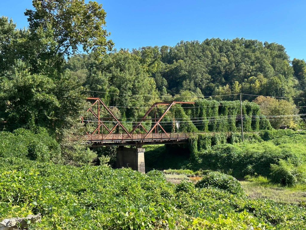
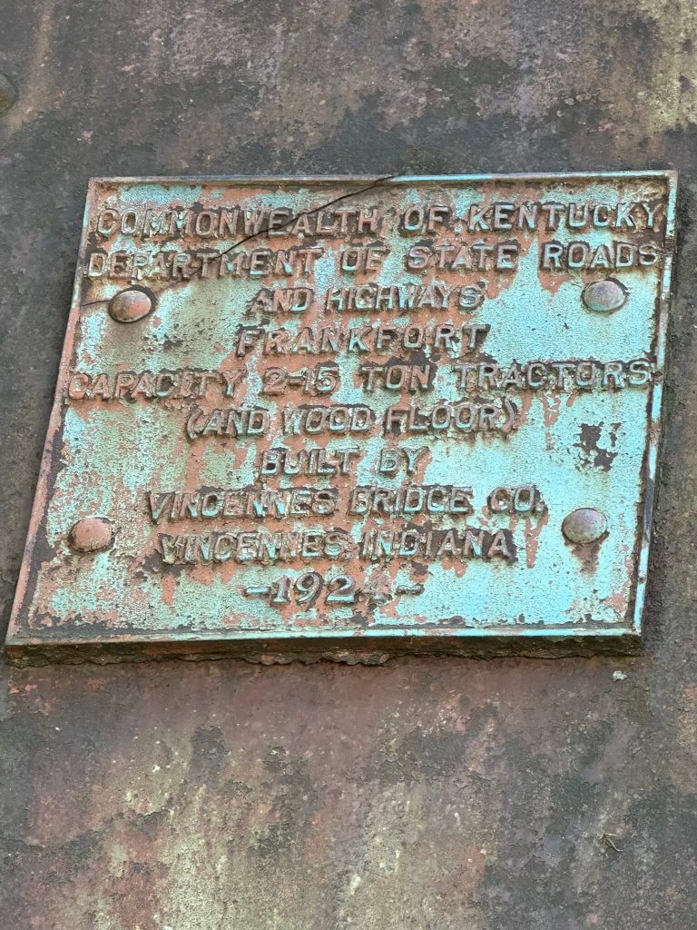
Baxter Bridge stands in the tight bend between Harlan and Loyall, where the Clover Fork and Martin’s Fork help form the upper Cumberland River. For most of the twentieth century this was one of the main river crossings on the road into Harlan from the west and north. HistoricBridges.org identifies the span as carrying Kentucky Route 840 over the combined channel of the Cumberland River and Clover Fork, with a total length of about 306 feet and a main span of roughly 150 feet. The site’s inventory credits the Vincennes Bridge Company of Indiana with its construction in 1924 and 1925.
Before traffic engineers renumbered and bypassed the corridors, this was part of U.S. 119. The same HistoricBridges entry notes that the bridge served as the U.S. 119 crossing and that the old U.S. 421 junction stood at its north end, which helps explain the scale of the structure in what now feels like a side road.
Today the Kentucky Transportation Cabinet’s State Primary Road System listing shows KY 840 running in two legs: from U.S. 119 near Tremont to U.S. 119 at Keith, and then from another junction with U.S. 119 through Loyall to U.S. 421. The whole route covers 6.009 miles and curls around Baxter and the modern flood protection works. The bridge stands along that loop, just down the hill from places like Rest Haven Cemetery, which modern guides place at 3000 KY 840 above Baxter and Keith.
If you have read about the Baxter Coal Monument, you have already met this crossing. That earlier essay notes that for decades travelers reached the monument along the old alignments of U.S. 119 and U.S. 421 and that “just down the way” stood a Baltimore through truss built by Vincennes in the 1920s, identified by HistoricBridges as the old U.S. 119 crossing with the old U.S. 421 junction at its north end.
Baltimore petite at Baxter and its sister span
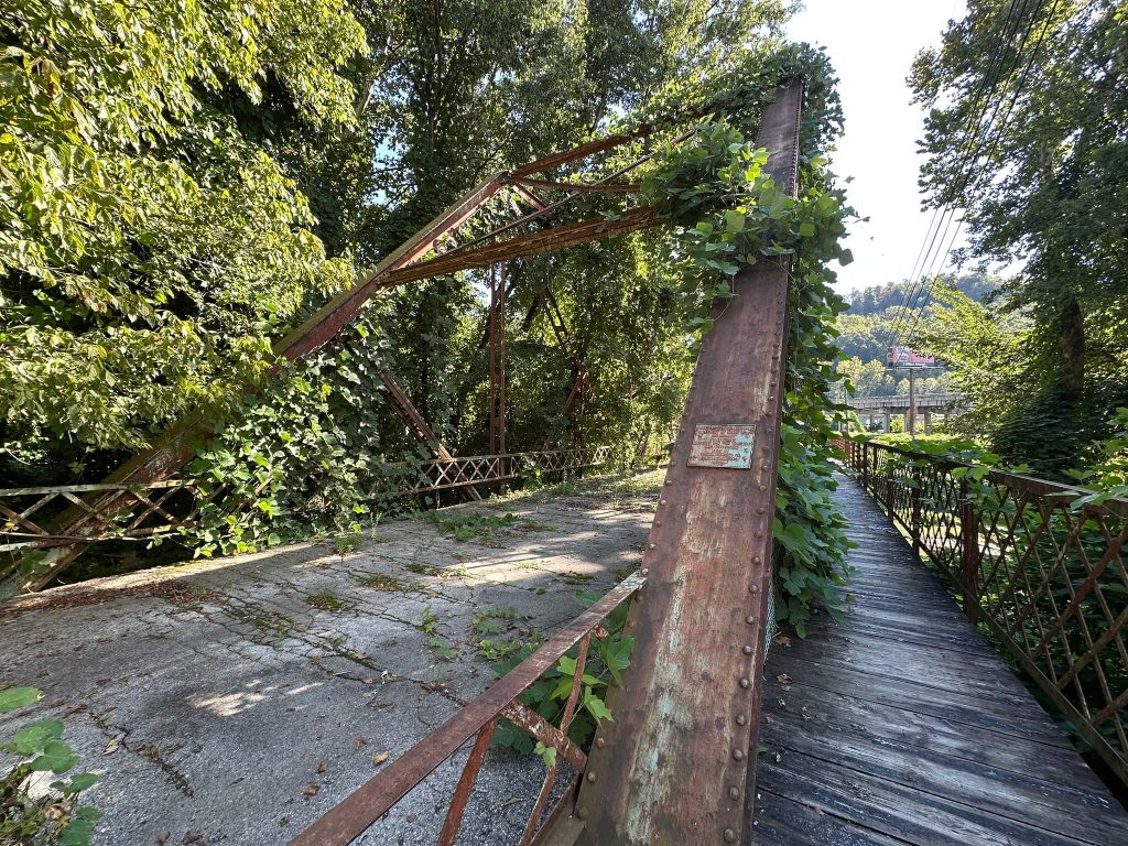
Structurally, Baxter Bridge is a steel Baltimore through truss: a variation on the more familiar Pratt truss in which the lower central panels are subdivided with extra diagonal and vertical members. That extra web stiffens the span for heavier loads and longer panels. HistoricBridges lists Baxter’s design as a Baltimore through truss, with a total length of about 306.1 feet and a 149.9 foot main span, all pin connected.
Just downriver, another Vincennes span once mirrored it. The “Old Highway 119 Bridge” entry in the same survey describes a Baltimore through truss over the Cumberland and Clover Fork that carried KY 840, also around 304 feet long with a 150 foot main span, built by the Vincennes Bridge Company in 1924 and rehabilitated in 1954. That span was removed in 1999 after the river was rerouted, and the HistoricBridges gallery for it is built from a Historic American Engineering Record (HAER) photo set that documents the portals, floor system, bearings, and builder’s plate in detail.
Together the two Vincennes trusses formed a small cluster of what Kentucky highway historians call “Baltimore petite” bridges. In a 2024 feature on Baxter Bridge’s centennial, the Harlan Enterprise quoted Historic Harlan Museum director Bronwyn Haynes describing the type. She noted that in 1924 the transportation authorities built three of these Baltimore petite bridges in Harlan County, that only six were ever built in Kentucky, and that Baxter’s span on KY 840 is now the last of the Harlan examples.
Statewide bridge surveys in the early 1980s treated these rare Baltimore variants as significant types. A Kentucky Transportation Cabinet historic context study explains that “A Survey of Truss, Suspension, and Arch Bridges in Kentucky” completed in 1982 created a statewide inventory and typology for notable bridge designs and later informed National Register evaluations. In that framework, the Harlan Baltimore petites stand out as a short lived but distinctive group tied to one region, one decade, and one builder.
A highway bridge in coal country
When Baxter Bridge opened in the mid 1920s, it did more than carry local traffic. U.S. 119 and U.S. 421 were the main automotive arteries for coal camps, sawmills, and small towns throughout Harlan County and beyond. Period maps show U.S. 119 dropping out of the mountains to cross the river at Baxter, then climbing along the forks toward the county seat, while U.S. 421 came in from the south and northeast to meet it at the junction near the bridge’s north portal.
Historic photographs from the HAER twin and the 2010 survey by bridge photographer Calvin Sneed show the details that motorists would have known as landmarks: tall portal bracing with lattice work above the roadway, riveted sway frames overhead, laced verticals and diagonals, and steel lattice guardrails along the deck. For residents of Baxter, Loyall, and Harlan, this was not an abstract piece of engineering. It was the way to town, the path to school and church, and the route coal trucks used as they moved out to market.
Oral history picked up in local Facebook groups and photo captions remembers the bridge in exactly those terms. A popular post from The Appalachian Project labels one photograph “an old abandoned bridge in Harlan County, Kentucky in the community of Baxter,” and notes that it had once been a vital transportation link before traffic left it for newer routes.
Floods, tunnels, levees, and a new river
The same river that made Baxter a natural crossing also made it vulnerable. The catastrophic 1977 flood devastated parts of Harlan, Loyall, and the Georgetown neighborhood and set in motion the long federal project that would eventually bypass Baxter Bridge. The U.S. Army Corps of Engineers summarized that work in a 2019 article marking the twentieth anniversary of the Harlan Flood Control Project’s completion.
The Corps describes a three phase effort authorized under Section 202 of the 1981 Energy and Water Development Act, aimed at providing at least 100 year flood protection for Harlan, Baxter, Loyall, and Rio Vista. In phase one, engineers blasted four two thousand foot tunnels through Ivy Hill and diverted Clover Fork around downtown Harlan. The river began flowing through those tunnels in September 1992.
In phase two the Corps built a four thousand foot floodwall along Highway 421 and Martins Fork in Harlan, with highway and railroad floodgates and an 875 foot levee segment to protect the business district.
Phase three changed Baxter’s landscape most directly. The Corps diverted a 3,800 foot stretch of the Cumberland River around the city of Loyall, constructed about 6,000 feet of levee to shield Loyall and Rio Vista, and built new bridges at Highway 840 and Park Street along the relocated channel. A separate two thousand foot floodwall, more floodgates, and railroad relocations rounded out the work. Officials dedicated the completed project on October 25, 1999.
Federal project documents are dry, but they describe in precise terms the river and road choreography that made Baxter Bridge redundant. Once the new KY 840 crossings and levees stood in place and the river no longer flowed where the old highway alignment crossed, transportation agencies could remove or abandon older spans.
The 2008–2014 Kentucky Six Year Highway Plan shows one piece of that transition. In the Harlan County section, a project entry calls for replacing a “bridge over Cumberland River (B89) 0.1 mi N JCT KY-840,” a planning note that likely corresponds to one of the newer Cumberland crossings built in the wake of the flood control project.
HistoricBridges notes that Baxter Bridge itself had already been bypassed once before the big federal works began. The listing explains that a new U.S. 421 bridge opened in 1977 and shifted primary highway traffic off the old alignment, leaving Baxter’s span on a secondary route. The bridge finally closed to traffic in 1993.
The sister Old Highway 119 Bridge lasted a few years longer. Its HistoricBridges entry records that it was replaced in 1999 and that the span was removed because the river had been rerouted in such a way that no bridge was needed at that exact point anymore.
From through route to abandoned landmark
With traffic gone and a new river course and levee system in place, Baxter Bridge slid into a kind of suspended life. Modern photographs in the HistoricBridges gallery show the deck gated off, the portal bracing boarded up or fenced, and rust working across the built up members.
Local photographers and writers have returned to that image again and again. The Substack essay “Decayed and Delayed: Capturing the Vulnerable Infrastructure of Eastern Kentucky” uses Baxter Bridge as one case study in a wider pattern of aging roads and structures in coal country. It links derelict bridges like this one to outmigration, shrinking tax bases, and the slow pace of infrastructure investment.
YouTube fieldwork has also preserved the bridge in motion. In “Harlan Kentucky’s Coal Monument and an Abandoned Bridge,” creator Ignited Coyote walks viewers from the coal monument down toward the closed span and explains how the construction of the bypass and new alignments took traffic away from the old truss. Another video from the same channel pairs the Baxter span with a restored truss in Corbin, Kentucky, highlighting how one bridge became a park feature while the other rusts behind barricades.
Social media posts from groups like Abandoned Kentucky and local Harlan history pages treat the bridge as both a nostalgic object and a warning. Captions recall first drives over the narrow deck, close calls on winter mornings, and the sting people felt when they saw boards go up across the portals.
A centennial for the last of Harlan’s Baltimore petites
In the summer of 2024, the community paused to mark Baxter Bridge’s hundredth year. The Harlan Enterprise feature “Iconic Harlan County bridge sees 100 years” reports that local historians and residents gathered near the coal monument to celebrate the centennial of the bridge on KY 840.
In that piece, Historic Harlan Museum director Bronwyn Haynes lays out why the bridge matters. She points out that transportation officials built three Baltimore petite spans in Harlan County in 1924, that only six such bridges were built across Kentucky, and that Baxter Bridge is now the last of its type still standing in the county. The article also captures the mood of the event, from a cake decorated in the likeness of the truss to the mix of pride and worry as people talked about the structure’s decaying condition.
The celebration did not instantly produce a preservation plan, but it fixed the bridge in the county’s public memory as something more than an eyesore. It is now clearly recognized as a rare survivor and as a touchstone for stories about roads, floods, coal, and community identity.
Reading Baxter Bridge on the ground
For visitors, the safest way to “read” Baxter Bridge is from the public roads around it. KY 72 and KY 840 near the Baxter Coal Monument offer clear views of the truss framed by the newer highway and flood control works. The coal monument essay already suggested exploring the area to understand how older geometry wrapped around the obelisk. The bridge is the other half of that lesson.
New levees and riverbanks created by the Harlan Flood Control Project define what you see today. The U.S. Army Corps of Engineers photo set from the late 1990s shows construction crews cutting the new Cumberland channel at Loyall and hauling fill for the levees that protect Loyall and Rio Vista while the new KY 840 and Park Street bridges rise in the background. Standing at Baxter, you can line up that documentation with the present view and see how the river was moved around the town.
Because the bridge is closed and in deteriorating condition, it is important not to walk out onto the deck or bypass gates and fences. The beauty of the HAER images and HistoricBridges photography is that they give close looks at floorbeams, bearings, and connections without asking anyone to risk a fall or trespass.
Where the paper trail runs next
The sources used here suggest a rich set of records still waiting in boxes and filing cabinets. Kentucky Transportation Cabinet bridge files for Baxter Bridge and its KY 840 mate should contain original plan sheets, contractor records, inspection reports, and closure orders. The mid 1980s cultural resource survey mentioned on the HistoricBridges Old Highway 119 page points toward detailed site forms and photographs housed with the Cabinet or the Kentucky Heritage Council.
Local records are likely just as important. Harlan County Fiscal Court minutes from the 1920s and 1930s may document right of way purchases, county participation in U.S. 119 and U.S. 421 improvements, and perhaps even the naming of Baxter Bridge. The Harlan Enterprise’s own archives, plus regional photograph collections at the Harlan County Public Library, the Historic Harlan Museum, and university archives in Lexington, Berea, and Richmond, likely hold early images of the bridge in ordinary use and in flood events.
Taken together with federal project reports for the Harlan Flood Control Project, these records can help future researchers trace in detail how a pair of Baltimore petite bridges came to span the forks of the Cumberland, how flood and policy stripped one of them away, and how the last survivor now stands as both relic and reminder.
Sources & Further Reading
HistoricBridges.org. “Bridge Locator: Baxter Bridge (KY 840) and Old Highway 119 Bridge (KY 840), Harlan County, Kentucky.” Accessed December 31, 2025. https://historicbridges.org/b_h_fipsm.php?bsearch=21095
Bridgehunter.com. “Baxter Bridge (Harlan County, Kentucky).” Accessed December 31, 2025. https://www.bridgehunter.com/bridges/46408
Bridgehunter.com. “Old Highway 119 Bridge (Harlan County, Kentucky).” Accessed December 31, 2025. https://www.bridgehunter.com/bridges/18811
U.S. Army Corps of Engineers, Nashville District. “Harlan Flood Control Project dedicated 20 years ago.” October 25, 2019. https://www.lrd.usace.army.mil/News/News-Releases/Article/3729323/harlan-flood-control-project-dedicated-20-years-ago/
U.S. Army Corps of Engineers, Nashville District. “Harlan Flood Control Project dedicated 20 years ago.” October 25, 2019. https://www.lrd.usace.army.mil/News/Display/Article/3729323/harlan-flood-control-project-dedicated-20-years-ago/
U.S. Army Corps of Engineers. “City of Cumberland, Harlan County, KY: Fact Sheet (as of February 2016).” PDF. https://usace.contentdm.oclc.org/digital/api/collection/p16021coll7/id/2530/download
United States. Public Law 96-367, 94 Stat. 1331 (Oct. 1, 1980). PDF. https://www.congress.gov/96/statute/STATUTE-94/STATUTE-94-Pg1331.pdf
Kentucky Transportation Cabinet. “State Primary Road System Lists: Harlan County (January 2, 2024).” PDF. https://transportation.ky.gov/Planning/State%20Primary%20Road%20System%20Lists/Harlan.pdf
Kentucky Transportation Cabinet. “Official Highway Map.” Accessed December 31, 2025. https://transportation.ky.gov/Pages/Map.aspx
Kentucky Transportation Cabinet. “Historic Themes for the Evaluation of Kentucky Highway Bridges, 1780–1940.” PDF. https://transportation.ky.gov/Archaeology/Documents/1992_Historic%20Themes%20for%20the%20Evaluation%20of%20KY%20Hwy%20Bridges%201780-1940.pdf
Kentucky Transportation Cabinet. “Historic Highway Bridges in Kentucky, 1792–1950 (Volume I).” 1996. PDF. https://transportation.ky.gov/Archaeology/Documents/1996_Historic%20Highway%20Bridges%20in%20Kentucky_Volume1.pdf
Kentucky Transportation Cabinet. Abner, Amanda, and Rebecca Turner. “A Bridge to the Past: Truss Bridge Rehab (Conference Presentation).” 2012. PDF. https://transportation.ky.gov/Highway-Design/Conference%20Presentation/A%20Bridge%20To%20The%20Past%20Truss%20Bridge%20Rehab.pdf
Kentucky Transportation Cabinet. “2008 Highway Plan COMPLETE (Six-Year Highway Plan FY 2008–2014).” PDF. https://transportation.ky.gov/Program-Management/Highway%20Plan/2008%20Highway%20Plan%20COMPLETE.pdf
Kentucky Transportation Cabinet. “2012 Highway Plan COMPLETE.” PDF. https://transportation.ky.gov/Program-Management/Highway%20Plan/2012%20Highway%20Plan%20COMPLETE.pdf
Kentucky Transportation Cabinet. “2014 Recommended Project Listing.” PDF. https://transportation.ky.gov/Program-Management/Highway%20Plan/2014RecommendedProjectListing.pdf
Kentucky General Assembly. “House Bill 267 (SCS2), 2012 Regular Session: 2012–2018 Biennial Highway Construction Plan.” PDF. https://apps.legislature.ky.gov/record/Budget/12RS/HB267SCS2.pdf
National Park Service. “HAER Guidelines: Historical Reports.” PDF. https://www.nps.gov/subjects/heritagedocumentation/upload/HAER-Guidelines-Historical-Reports_508.pdf
Wikimedia Commons. “Category: Kentucky Route 840 Bridge, Spanning Cumberland River, Loyall, Harlan County, KY (HAER).” Accessed December 31, 2025. https://commons.wikimedia.org/wiki/Category:Kentucky_Route_840_Bridge,_Spanning_Cumberland_River,_Loyall,_Harlan_County,_KY_HAER
University of Pennsylvania, The Online Books Page. “Browse subject: Roads—Kentucky—Periodicals (including Kentucky Dept. of Highways biennial reports via HathiTrust).” Accessed December 31, 2025. https://onlinebooks.library.upenn.edu/webbin/book/browse?c=x&key=Roads+–+Kentucky+–+Periodicals&type=lcsubc
Kentucky. State Highway Commission. Biennial Report of the Department of Public Roads Made to the Governor and General Assembly of Kentucky. (Digitized volume listing). Accessed December 31, 2025. https://books.google.com/books/about/Biennial_Report_of_the_Department_of_Pub.html?id=H7Q-AQAAMAAJ
Tennessee Department of Transportation. “Historic Bridges (TDOT Historic Bridge Documentation, Chapter 6B).” PDF. https://www.tn.gov/content/dam/tn/tdot/structures/historic-bridges/Chapter6b.pdf
Harlan Enterprise. “Iconic Harlan County bridge sees 100 years.” July 31, 2024. https://harlanenterprise.net/2024/07/31/iconic-harlan-county-bridge-sees-100-years/
Author Note: I drove by Baxter Bridge nearly every school day when I was younger, riding toward Harlan County High School with that riveted truss standing over the forks like a fixed landmark in my window. Even closed and quiet now, it still takes me back to those mornings and reminds me how the roads we grow up on become part of who we are.