Abandoned Appalachia Series – Cubbage Elementary School
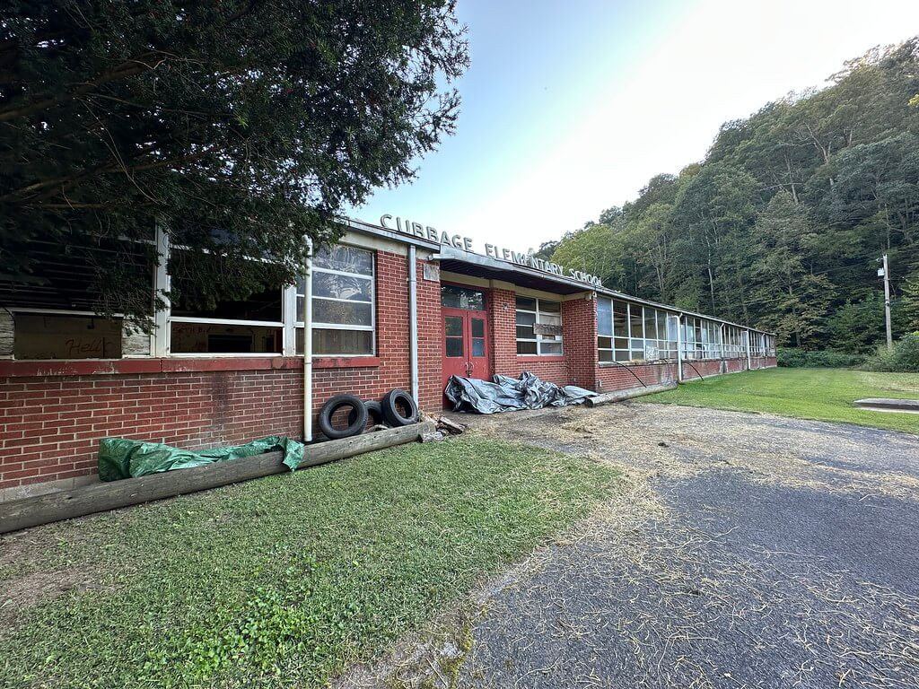
On the far southeastern side of Bell County, the pavement of KY 987 follows Browney’s Creek through a narrow valley of houses, gardens, and old mine roads. Near the junction with KY 219, a long brick school building still stands beside the road. Maps and local memory call it Cubbage Elementary or simply “Cubbage School,” after the Cubage or Cubbage community that grew up along the creek.
Like many rural schools in central Appalachia, Cubbage was never just a building. It was a small county elementary school that grew out of coal company land and a community’s insistence that children on this outlying creek deserved a classroom of their own. Its story runs from a 1930s deed carved out of a coal tract, through mid twentieth century school building campaigns and water regulations, to the school consolidation fights of the 1990s.
Coal land and a school lot
The legal story of the site begins in 1932, when the Kentucky and West Virginia Coal and Mining Company conveyed a small tract on Browney’s Creek to a group of trustees for what was then called the Browney’s Creek Community School. The deed set off roughly two acres from a larger coal holding and limited their use to “school and educational purposes,” with a reversion if the land ever ceased to be used for a school or for housing teachers, staff, or students. Later, in a federal dispute over mineral rights under the tract, the court opinion would quote the 1932 deed almost in full while reconstructing the chain of title from the coal company to the school trustees and then to the Bell County Board of Education.
That paper trail captures a familiar pattern. Coal companies across eastern Kentucky routinely granted or leased small plots for schools and churches, often retaining mineral rights or building in reversion clauses that would matter only decades later. At Cubbage, the company’s conveyance allowed the county to formalize a community school that was already taking shape along Browney’s Creek and gave the local trustees a legal foothold for improvements.
Property records in the Bell County clerk’s office, building on the citation preserved in the federal case, trace how the Browney’s Creek school lot passed into the hands of the Bell County Board of Education as the county gradually consolidated community schools into a unified district. Later parcel cards and tax records show the school acreage, building footprint, and eventual transfer of the tract once the building left active educational use.
From Browney’s Creek school to Cubbage Elementary
Early topographic maps of the Varilla quadrangle show a simple school symbol along Browney’s Creek, south of Pineville and north of the line toward Hensley Settlement and Brush Mountain. As the U.S. Geological Survey updated its maps in the mid twentieth century, the feature label “Cubbage School” appears along the creek, with the road network and nearby named places such as Miracle, Cubage, Oaks, and Brownies Creek stations gradually filling in around it.
By the middle of the twentieth century, the school had taken on the name Cubbage or Cubage in county directories and on state highway maps. The school served a string of families whose names recur in Bell County histories and in place-name work about the Cubage post office and the nearby hollows. Robert Rennick’s research into Kentucky place names traces the Cubage or Cubbage name to the community along this creek, explaining why the school and the post office sometimes carried slightly different spellings in official records.
The building that survives today reflects Bell County’s mid century school building program. Photographs and on-site notes show a one-story brick rectangle with seven or eight classrooms aligned along one side of a central corridor and offices, restrooms, and a cafeteria on the other. A portable classroom stands behind the school, a familiar solution when enrollment briefly outgrew the original floor plan.
State highway maps and transportation reports place the Cubbage building directly off KY 987 near the crossing of Brownies Creek, with bus turnouts and small parking areas linked to the road. One Kentucky Transportation Cabinet environmental document for a nearby bridge project uses the school as a reference point and includes a labeled photograph of the building’s north elevation, capturing its appearance in the early 2000s.
Daily life in a small Bell County school
For much of its life, Cubbage Elementary was one of several small Bell County schools that served the lower grades for children who lived far from Pineville or Middlesboro. Annual Kentucky School Directory volumes list it among the county’s elementary schools, usually with a short entry that gives its name, grade span, and principal. Over the decades its grade configuration shifted with policy and enrollment, but it remained a neighborhood school for families along Browney’s Creek and neighboring hollows.
Newspaper columns in the Middlesboro Daily News, the Pineville Sun, and the Harlan Daily Enterprise carried the routine notices that stitched small schools into county life. Honor rolls, Christmas programs, and 4-H announcements listed Cubbage among the participating schools. Occasionally, a feature story on rural education or a human interest column about Browney’s Creek would mention Cubbage students and teachers by name.
More personal glimpses appear in obituaries and memory notes. One obituary for a Bell County woman, for example, includes a remembrance from a former student whose sister “had Blanche as a teacher at Cubbage Elementary School,” a small but concrete reminder of the staff who kept the school running and of the affection former pupils felt for them.
Together these scattered notices confirm what the building and bus routes suggest. Cubbage was a close-knit K to 5 or K to 6 school where teachers taught multiple subjects, principals doubled as disciplinarians and bus coordinators, and the auditorium or cafeteria served as a catch-all space for fall festivals, election day suppers, and school plays.
Water systems, regulations, and a shrinking enrollment
By the late twentieth century, rural schools were increasingly tied into state and federal infrastructure systems. Cubbage’s water supply became part of that story. In October 1999, a regional “Water Resource Development” plan for the Cumberland Valley Area Development District treated Cubbage Elementary as a separate non transient, non community public water system. The Bell County section listed the school as serving a population of about ninety through three service connections, supplied by wells with a treatment capacity of roughly ten thousand gallons per day.
The same planning documents, preserved through the Kentucky Infrastructure Authority’s Water Resource Information System, carried Cubbage forward as a distinct water system tied into the broader Bell County network. That status marks the school as still functioning in the late 1990s and shows how even a small outlying school was now part of a regulated drinking water regime that required sampling records, compliance reports, and eventual closure paperwork when the system went offline.
At the same time, Bell County’s school board was dealing with aging buildings and declining enrollment in its smallest elementaries. Local coverage and later reminiscences recall the 1999 to 2000 school year as a turning point. Facing budget constraints and a shrinking student body, the Board voted to close several rural schools and consolidate students into larger campuses. Cubbage, the southeastern most Bell County elementary school, was among those slated for closure. Jamie Middleton’s 2015 field report on the school notes that in the 1999 to 2000 year Cubbage’s enrollment had slipped to eighty nine students, a figure that aligns closely with the ninety person population recorded in the water system plan.
Closure, reversion, and a title fight
When the last class left and the buses stopped making daily runs to Browney’s Creek around 2000, the 1932 deed’s reversion clause finally came into play. Under the terms written seventy years earlier, the land could revert to the coal company’s successor once it ceased to be used for school or educational housing purposes.
That scenario is exactly what unfolded in the federal case Black Mountain Energy Corp. v. Bell County Board of Education. The coal company, as successor to the Kentucky and West Virginia Coal and Mining Company, argued that the Board’s decision to declare the school surplus and use it no longer for student instruction triggered the reversion provision. The Board maintained that statutory reforms and later transactions had effectively extinguished or modified the reversionary interest. The opinion traces the entire chain of title, reproduces the 1932 deed language, and concludes that the state’s limitation on such future interests could be constitutionally applied, resolving the immediate contest over who owned the tract.
For the community, the legal wrangling mattered less than the visible reality. Whatever name appeared on the deed once the case ended, the building had left the public school system and passed into private hands.
An abandoned campus on Browney’s Creek
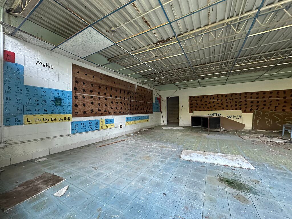
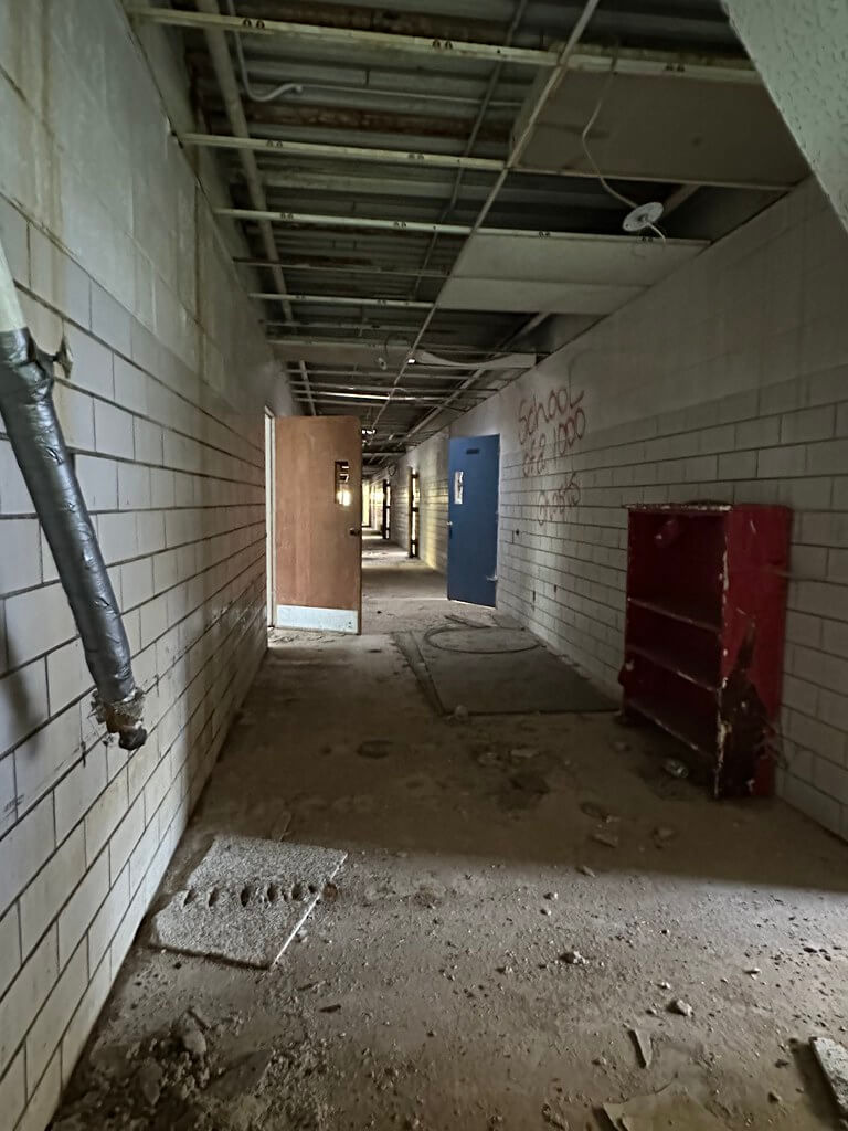
Photography from the mid 2010s captures Cubbage Elementary a decade and a half after the last bell. Exterior shots show the long brick facade with broken windows, missing ceiling tiles behind the glass, and graffiti on the walls. Interior images reveal hollow classrooms, exposed metal ceiling grids, linoleum or tile floors littered with debris, and remnants of science posters and chalkboards. In the cafeteria, folding tables that once swung down from the walls still hang in place, weathered but recognizable.
A mobile classroom remains behind the main building, its siding faded and steps sagging. Kudzu, saplings, and tall grass creep into the bus turnout and parking areas. Flickr photographs and social media posts by local explorers and former students document these changes over time, turning the abandoned school into a minor landmark of “abandoned Appalachia” for people interested in rural school history and urban exploration alike.
State transportation reports, prepared for bridge and road work on Brownies Creek, include dated photographs of what they call the “former Cubbage Elementary School,” anchoring the building in official records even in its closed state.
Today, the shell of Cubbage still stands along the creek, visible from the roadway in the Miracle area and from public pull offs. As with many former schools, the property is now privately owned. Visitors who want to see the building should respect posted signs, remain on public rights of way, and treat the site with the same care they would give to a remote churchyard or family cemetery.
Why Cubbage still matters
Cubbage Elementary’s story is in some ways ordinary. It was a small county school built on land carved out of a coal tract, staffed by a handful of teachers, and closed when enrollments dropped and consolidation seemed inevitable. Yet the records that survive make it an unusually well documented example of how land law, environmental regulation, and community memory intertwine around a rural school.
The 1932 deed and the later court case show how company land and public education were entangled in coal country. The water system records reveal how even a ninety pupil school had to navigate regulatory oversight and infrastructure planning. Topographic maps, highway reports, and photographs fix the building in the physical landscape of Browney’s Creek and Miracle. Newspaper clippings, obituaries, and online comment threads preserve the human side, from favorite teachers to recollections of bus rides and Christmas programs.
For Bell County and for Appalachia more broadly, Cubbage stands as a reminder that education has always depended on more than a classroom. It required negotiated access to land, the slow expansion of roads and utilities, and the willingness of families on outlying creeks to send their children down the valley to a school that might one day disappear. The empty halls on Browney’s Creek still hold that history, even after the desks and chalkboards are gone.
Sources & Further Reading
Black Mountain Energy Corp. v. Bell County Board of Education, 467 F. Supp. 2d 715 (E.D. Ky. 2006). https://www.govinfo.gov/content/pkg/USCOURTS-kyed-6_05-cv-00655/pdf/USCOURTS-kyed-6_05-cv-00655-0.pdf
United States Geological Survey. “Monitoring Location Brownies Creek Near Oaks, KY (USGS 03401290).” USGS Water Data for the Nation.
https://waterdata.usgs.gov/monitoring-location/03401290/
TopoQuest. “Cubbage School, KY (N36.70425 W83.55019).” TopoQuest Map Viewer. https://topoquest.com/map.php?coord=d&datum=nad83&lat=36.69768&lon=-83.54458&map=24k&mode=zoomout&size=m&zoom=128
TopoQuest. “Brownies Creek, KY (Place Detail).” TopoQuest Map Viewer. https://topoquest.com/place-detail.php?id=488020
Mapcarta. “Cubbage School, Bell County, Kentucky, United States.” Mapcarta.
https://mapcarta.com/20924106
Jamie in Wanderland. “Cubbage Elementary School, Bell County, Kentucky.” Jamie in Wanderland (blog), November 5, 2015. https://jamieinwanderland.wordpress.com/tag/bell-county/
Kala Thornsbury. “Cubbage Elementary School.” Flickr photo album, Appalachia collection.
https://www.flickr.com/photos/202678837%40N08/albums/72177720329666067
Rennick, Robert M. “The Post Offices of Bell County, Kentucky.” In Kentucky County Histories series. Morehead State University, 2000 (PDF). https://scholarworks.moreheadstate.edu/cgi/viewcontent.cgi?article=1382&context=kentucky_county_histories
Rennick, Robert M. Kentucky Place Name Pronunciations. Manuscript, 1987 (PDF). https://scholarworks.moreheadstate.edu/cgi/viewcontent.cgi?article=1160&context=rennick_ms_collection
“Cubage, Kentucky.” Wikipedia: The Free Encyclopedia.
https://en.wikipedia.org/wiki/Cubage%2C_Kentucky
Fuson, Henry Harvey. History of Bell County, Kentucky, Volume II. New York: Hobson Book Press, 1947. Digitized PDF, Bell County Public Library District. https://www.bellcpl.org/uploads/4/2/6/7/42679073/history_of_bell_county_kentucky.pdf
“Bell County, Kentucky.” Wikipedia: The Free Encyclopedia. https://en.wikipedia.org/wiki/Bell_County%2C_Kentucky
Kentucky Transportation Cabinet. “Call No. 329, Bell County, Project 25-2986.” Construction proposal, 10 April 2025 (PDF). https://transportation.ky.gov/Construction-Procurement/Proposals/329-BELL-25-2986.pdf
“Bell County – Abandoned Kentucky (includes photos of Cubbage School).” Facebook group post, Abandoned Kentucky. https://www.facebook.com/groups/AbandonedKentucky/posts/2216982891718354/
Tri-State Tradio. “Tradio | Pineville KY” (local classified posts including reference to ‘Cubbage school’). Facebook page. https://www.facebook.com/TriStateTradio/
Author Note: The drive from Smith feels like you’re slipping into the backroads, with creek bends and long quiet stretches. You pass only a few houses, not many at all. Then Cubbage Elementary appears right beside the road, easy to spot despite the out-of-the-way setting. The building is locked and on private property. Please do not trespass. Enjoy it only from public pull-offs or the shoulder and leave the place undisturbed.