Abandoned Appalachia Series – Abandoned Appalachia: The Smith Garage of Harlan County
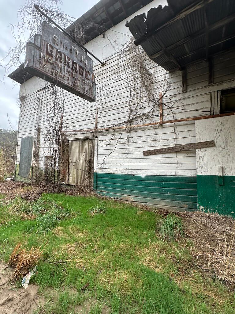
On the old road through Baxter, just north of Harlan, a wood sided garage still faces the traffic that no longer really comes. The paint has peeled to gray, green base trim flakes off in curls, and vines run along the clapboard like ropes. Out by the shoulder, a heavy metal pole sign hangs over the lot. Faded letters still read “Smith Garage Machine Shop Wrecker Service,” and you can almost imagine the neon that once traced the arrow toward the bays.
The building stands at 192 State Highway 72 in Baxter, an unincorporated community where KY 72 meets the old alignment of US 421 at the confluence of Martin’s Fork and Clover Fork of the Cumberland River. Just down the way, a coal block obelisk called the Baxter Coal Monument rises from a wedge of ground in the fork of the roads, a roadside memorial to the miners and mines that fueled twentieth century Harlan County. Together the monument, Jones Motel on the hillside, and Smith Garage on the low ground made this crossroads one of the most recognizable little pockets of coal country.
This article pieces together the history of Smith Garage from scattered primary sources. Newspaper advertisements, highway maps, postcards, engineering plans, and modern photographs tell the story of how a family run machine shop grew up beside a busy coal highway, worked hard through the county’s boom years, and then slipped into quiet ruin when the traffic moved away.
A Garage at the Forks
The official record keeps Baxter modest. The U.S. Geological Survey’s place file for “Baxter” tags it simply as a populated place in Harlan County, gives its GNIS feature ID as 486480, and notes its position where Martin’s Fork joins Clover Fork to form the Cumberland River. In the mid twentieth century that river junction was also a road junction. US 421 and US 119 came together here, with KY 72 bending off toward Harlan and Loyall.
A 1950 and then a 1959 General Highway Map of Harlan County, prepared by the Kentucky Department of Highways, show Baxter as a tiny cluster of symbols at the forks. The later map uses icons to indicate services. At the KY 72 and old US 421 junction a symbol for an auto garage appears beside the road, confirming that by the end of the 1950s the state considered this a reliable service point for motorists.
Coal explains why such a small bend in the river needed a garage at all. Mid century coal employment in Harlan County reached more than 13,000 miners in 1950. Those paychecks moved in and out of the valley on four wheels. Men drove to the mines at dawn, hauled families to town on Saturdays, and pulled campers and boats up and down the gaps on rare off days. Thousands of coal county vehicles pounding the same roads meant constant work for a shop that could straighten a fender, weld a spring, or keep an aging truck on the road one more year.
The coal monument that still stands at Baxter, dedicated in May 1932 as a tribute to Kentucky miners and the coal industry, drives the point home. The obelisk predates Smith Garage by about two decades, but it set the pattern: this little triangle of ground at the forks would be a place where the county told its story in coal and concrete.
Building a Postwar Roadside Business
Smith Garage belongs to a postwar wave of roadside building that reshaped Baxter and many similar Appalachian crossroads. Postcards and travel guides for the Jones Motel across the road provide the best clues. Linen and chrome cards of “Jones Motel, Harlan, Kentucky” begin appearing around the early 1950s. A real photo postcard postmarked 1952 shows a fresh motor court tucked against the hillside with cars angled in beside the rooms.
Your own research into the motel has shown that its owner, Matt Jones, promoted the property as standing on US 119 and 421, with file bath rooms, a large pool, and proximity to mountain scenery. The motel offered fuel pumps by the highway and a small café, making it a one stop place to eat, gas up, and sleep.
On the opposite side of the road, Smith Garage filled the final gap in that complex. A display advertisement in the Harlan Daily Enterprise dated 14 May 1951 announces “Smith Garage Welding and Wrecker Service” and places the business on the Harlan Baxter road. That ad confirms that by the early 1950s the garage was operating as a named business serving both local residents and highway travelers.
Taken together, the postcards and newspaper notice suggest a tight construction window. The motel appears in cards dated 1952. The garage is already advertising in 1951. The highway map published in 1959 treats the junction as a mature service node with a garage symbol already in place. It is reasonable to place the construction of Smith Garage and the full build out of the roadside complex in the very late 1940s or earliest years of the new decade, when postwar car ownership and coal incomes crested together.
Bascom Smith and a Landmark Garage
The word “Smith” in Smith Garage is not anonymous in local memory. Facebook genealogy and nostalgia groups for Harlan County families preserve comments from people who grew up at Baxter in the 1950s and 1960s. Several recall living “on the hill across from Bascom Smith’s garage” or mention “Baxter Automotive, Margaret Smith and Bascom Smith” as the owners of the business.
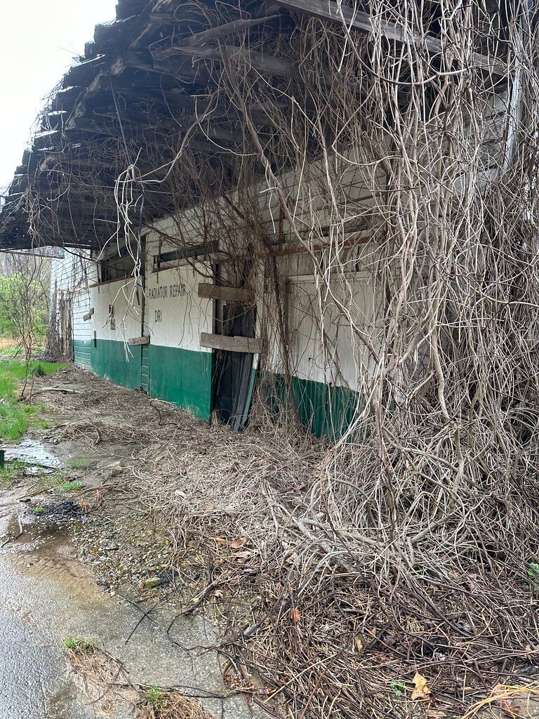
A 1963 legal notice in the Harlan Daily Enterprise refers to “Bascom Garage, Baxter” conducting a sale at its place of business. While the wording is slightly different from “Smith Garage,” the combination of the surname, the roadside location, and the community memories suggests that Bascom Smith and his family operated the building that locals still associate with the Smith name.
These recollections do not yet have a matching stack of deed books or incorporation papers that would nail down every transfer and trade name, but they make one fact clear. For the people who lived in Baxter, the garage was not just a roadside service icon on a map. It was “Bascom’s garage,” a place that anchored directions, everyday repairs, and neighborhood identity.
Inside the Bays
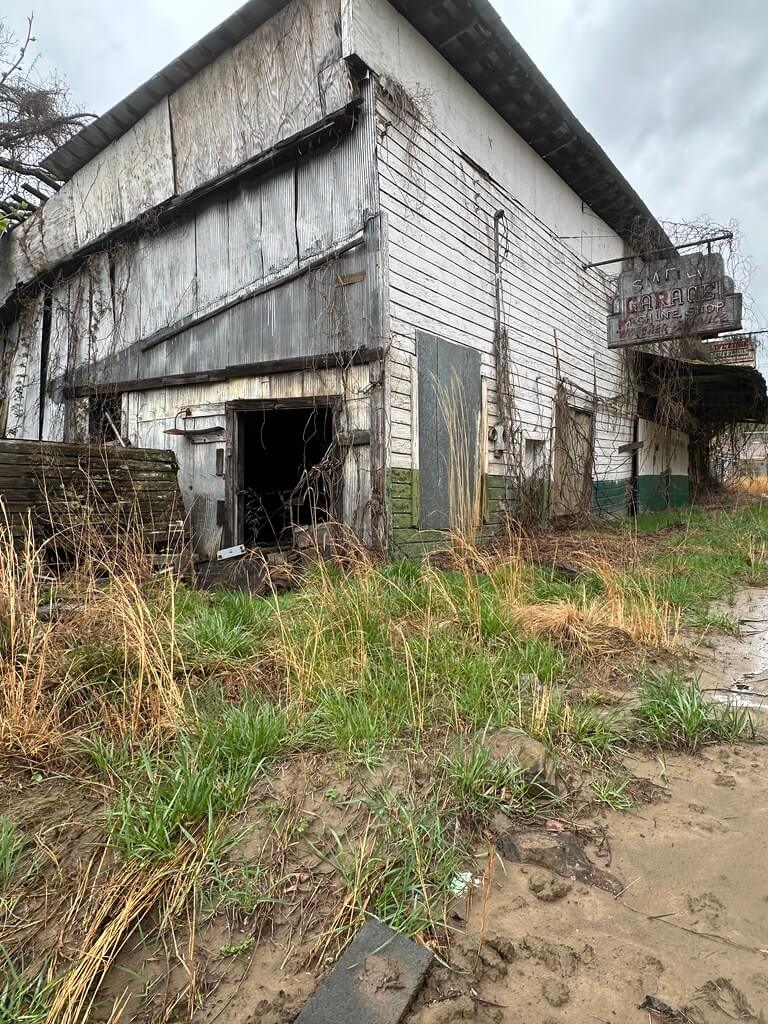
Modern visual documentation lets us read the building itself. Photographer Kala Thornsbury’s 2025 Flickr set “Jones Motel and Smith’s Garage: Harlan, KY” contains seventeen images of the complex from the public right of way. The Smith Garage shots show a long rectangular structure with wood siding facing the road, a metal roof that overhangs the sidewalk, and two deeply set bays with wide openings. The green painted base trim rings the building at ground level.
A freestanding steel pole sign planted near the corner carries the stacked legend “SMITH GARAGE MACHINE SHOP WRECKER SERVICE.” A close up Instagram photograph of the neon sign catches the wording in detail and confirms that the arrow once lit up to direct drivers into the lot.
A YouTube walkthrough filmed by urban exploration channel Ignited Coyote circles the property in daylight. The video shows the garage’s relationship to the motel above it and to KY 72 below. The bays are tall enough for coal trucks or buses, with heavy lintels and concrete floors. Small window openings along the side walls once brought light to a work area that likely contained lathes, drill presses, and welding rigs, even though most equipment has long been hauled away.
The architecture fits a pattern seen across rural Kentucky in the 1950s and 1960s. A simple rectangle with two drive through bays, a small office and parts counter at one end, and a machine corner in the back was enough to keep a local fleet running. The sign’s promise of machine shop work and wrecker service suggests that Smith’s crew handled more than flat tires. When a mine truck twisted a driveshaft, when a family sedan scattered its transmission seal halfway to Loyall, when a drunk driver put a Ford coupe into the ditch near the bridge, this was the place people called.
Roads Move Away
If coal and cars built Smith Garage, highways and mine layoffs slowly unbuilt it. Coal employment in Harlan County began to fall after the 1950 high point, dropping sharply through the 1960s as railroads switched fuels, factories converted to oil and gas, and mechanization cut the number of men needed underground. Fewer miners meant fewer paychecks and fewer cars needing work.
At the same time, state and federal transportation planners began rethinking the routes through the valley. Kentucky Transportation Cabinet right of way plans for a project labeled COR Harlan Co 54 3(12) laid out a new alignment of US 421 around Baxter. The “Baxter Bypass,” let to contract in March 1969, was designed to move through traffic away from the tight old junction and its aging bridges.
Later, the Harlan Flood Control Project, completed in the 1990s, altered river channels, added levees, and rebuilt approaches to nearby bridges in Harlan, Baxter, Loyall, and Rio Vista. Flood walls, tunnel diversions, and new spans made the old highway alignment less essential. Travelers coming from the Virginia line toward Harlan could now skirt Baxter rather than filing directly past Smith Garage and Jones Motel.
Local memory fills in the effects those projects had at ground level. Former Baxter residents recall that the motel’s diner quieted in the early 1970s. By the 1980s the neon at both the motel and the garage rarely lit up. Your earlier synthesis on Smith Garage places the building’s final closure around the mid 1980s, when coal traffic and through travelers had both thinned out and new motels closer to newer four lane sections pulled overnight guests away.
Abandonment and Afterlife
The story could have ended with a demolition crew, but in Baxter the road moved faster than the wrecking ball. Smith Garage remained standing as a convenient storage space and visual landmark, even after its bays stopped seeing regular automotive work.
By the early twenty first century, online forums and social media posts began to treat the complex as a curiosity rather than a working business. Dead Motels USA, a Tumblr site that catalogs abandoned roadside lodging, posted about Jones Motel in 2024 and used Street View grabs that show the motel balconies half hidden in foliage. Urban explorers and local photographers followed with their own shots of the coal monument, the old Baxter truss bridge, the motel, and the garage in varying states of decay.
Kala Thornsbury’s 2025 photographs and Ignited Coyote’s video fix the garage in this current phase. In their work, the pole sign leans slightly, the clapboard shows rot along the bottom courses, and the bay doors hang crooked or stand open to darkness. “No Trespassing” signs warn that the structure is not safe to enter, but the overall form of the garage remains clear enough that older residents still read it instantly as “Bascom’s place.”
Even in abandonment, the building continues to serve as a wayfinding point. Comments on Harlan County history groups use Smith Garage and Jones Motel as reference marks to explain where other houses or family plots once stood. The garage has moved from active business to shared mental map, a role many roadside structures take on at the end of their life.
Why a Small Garage Matters
On paper, Smith Garage is only a one story building on a short stretch of state highway in a small unincorporated place. In context, it ties together several important strands in Appalachian history.
It is a product of the coal boom that lifted Harlan County into a mid century peak and then left it with a cratered economy when demand shifted and production mechanized. It represents a class of family owned roadside businesses that thrived on the combined flow of coal trucks, local wage earners, and long distance travelers heading toward or away from the mountains. Its fortunes rose and fell alongside Jones Motel, showing how tightly motel, café, gas station, and repair shop were bound together in the era of motor courts.
The garage also illustrates how infrastructure decisions made in Frankfort and Washington echo into the smallest corners of the valley. The Baxter Bypass, the realigned bridges, and the flood control works were built to improve safety and protect lives, and in many ways they succeeded. At the same time, those projects moved traffic patterns just enough to starve roadside businesses that had depended on through travelers. The story of Smith Garage is not separate from the story of those public works. It is one of their local consequences.
Finally, Smith Garage is a reminder that ordinary work deserves a place in the historical record. Every day that the bays were open, people brought in the practical problems of their lives: a broken car needed to get a miner to third shift, a school bus that needed brakes before Monday, a vacationer stuck with a blown tire far from home. The building absorbed those stories. Preserving its history through careful use of primary sources, photographs, and oral memories makes sure that this small crossroads shop remains part of Harlan County’s narrative, even when the vines finally win.
Sources & Further Reading
Kentucky Department of Highways. General Highway Map Harlan County Kentucky, 1950. Map. Frankfort, KY: Kentucky Department of Highways, 1950. Berea College Special Collections and Archives, Collection of United States Maps and Atlases (BCA 0291). https://bereaarchives.libraryhost.com/repositories/2/archival_objects/163926
Kentucky Department of Highways. General Highway Map: Harlan County, Kentucky (1959 ed.). Map. Frankfort, KY: Kentucky Department of Highways, 1959. Kentucky Transportation Cabinet, Historic County Maps. https://transportation.ky.gov/maps/historic/har1959.pdf
“Baxter, Kentucky.” Wikipedia. Accessed December 28, 2025. https://en.wikipedia.org/wiki/Baxter%2C_Kentucky
“Harlan County, Kentucky.” Wikipedia. Accessed December 28, 2025. https://en.wikipedia.org/wiki/Harlan_County,_Kentucky
U.S. Geological Survey. Harlan, KY, 7.5 Minute Topographic Quadrangle. Map, 1:24,000. Washington, D.C.: U.S. Geological Survey, 1954; revised 1977. Access via USGS TopoView. https://ngmdb.usgs.gov/topoview/
U.S. Bureau of Mines. Minerals Yearbook: 1950. Washington, D.C.: U.S. Government Printing Office, 1953. Harlan County coal employment figures summarized in “Harlan County, Kentucky” Wikipedia entry. https://en.wikipedia.org/wiki/Harlan_County,_Kentucky
“Martins Fork Lake.” Wikipedia. Accessed December 28, 2025. https://en.wikipedia.org/wiki/Martins_Fork_Lake
U.S. Army Corps of Engineers, Nashville District. “Martins Fork Lake.” Archived web page, U.S. Army Corps of Engineers. Accessed via Wayback Machine, December 28, 2025. https://web.archive.org/web/20070318021218/http://www.lrn.usace.army.mil/op/mar/rec/
CardCow. “Jones Motel – Harlan, Kentucky.” Chrome postcard, publisher Durham, 3.5 by 5.5 inches. CardCow.com. Accessed December 28, 2025. https://www.cardcow.com/10842/harlan-kentucky-jones-motel/
eBay. “Vintage 1940’s Postcard Jones Motel Highway 119 and 421 Harlan Kentucky.” Vintage Paperboy seller listing 294185189950. Accessed December 28, 2025. https://www.ebay.com/itm/294185189950
eBay. “Jones Motel HARLAN Kentucky RPPC Vintage Roadside Photo Postcard 1952.” The Magic Postcard Store listing 223787168602. Accessed December 28, 2025. https://www.ebay.com/itm/223787168602
eBay. “Postcard Harlan KY Jones Motel.” Listing 236381535953. Accessed December 28, 2025. https://www.ebay.com/itm/236381535953
HipPostcard. “Jones Motel – Harlan, KY” and related postcards in search results for “KY HARLAN.” HipPostcard.com. Accessed December 28, 2025. https://www.hippostcard.com/search?keywords=KY+HARLAN+
WorthPoint. “1920s–1950s Kentucky Motel/Roadside Postcards (14) … Harlan, KY Postcard – Jones Motel – Roadside Motel – 28 Rooms – Posted. 1956 …” Auction archive. Accessed December 28, 2025. https://www.worthpoint.com/worthopedia/1920s-1950s-kentucky-motel-roadside-2853722955
Dead Motels USA. “Jones Motel of Harlan, Kentucky is abandoned and overgrown.” Dead Motels USA (Tumblr), August 14, 2024. Accessed December 28, 2025. https://deadmotelsusa.com/post/758840329626632192/jones-motel-of-harlan-kentucky-is-abandoned-and
Dead Motels USA. Instagram account @deadmotelsusa, posts featuring historic and modern views of Jones Motel in Harlan, Kentucky. Instagram. Accessed December 28, 2025. https://www.instagram.com/deadmotelsusa/
Thornsbury, Kala. “Jones Motel and Smith’s Garage: Harlan, KY.” Flickr photo set, 17 images, photographed April 6, 2025, uploaded April 14, 2025. Accessed December 28, 2025. https://www.flickr.com/photos/kala_t/
Instagram. “A vintage neon sign for the Smith Garage, Machine Shop, and Wrecker Service, found in a tiny community called Baxter in Kentucky coal country …” Instagram photo post showing the Smith Garage neon sign, accessed December 28, 2025. https://www.instagram.com/
YouTube. Abandoned Jones Motel and Smith’s Garage (Harlan KY). Video by Ignited Coyote documenting the abandoned complex at Baxter, Kentucky. Accessed December 28, 2025. https://www.youtube.com/
Roadside America. “Coal Monument – Baxter, KY.” Entry describing a coal monument at the forks of the Cumberland near Baxter, Harlan County. Accessed December 28, 2025. https://www.roadsideamerica.com/
Terry, Sam. “The Coal Monument.” Sam Terry’s Kentucky, May 22, 2025. Accessed December 28, 2025. https://samterryskentucky.com/
Facebook. “The Coal Monument at Baxter, Kentucky in Harlan County. Made …” Community discussion thread with photographs and reminiscences of the coal monument, Baxter bridge, and Jones Motel. Group post, accessed December 28, 2025. https://www.facebook.com/groups/675277952060182/posts/804049235849719/
Facebook. “Coal Memorial in Harlan, Kentucky, and Personal Memories.” Thread requesting and sharing photos of Jay’s Drive-In and Jones Motel at the Baxter bridge and coal monument. Group post, accessed December 28, 2025. https://www.facebook.com/groups/789010344491250/posts/8361720173886858/
Facebook. “Early 1970s photograph of the old Jones Motel that was located in Harlan Kentucky.” Group post sharing a historic roadside photograph, accessed December 28, 2025. https://www.facebook.com/groups/839092565052454/posts/1109338678027840/
Palgrave Macmillan. Discussion of the Harlan County coal monument and Baxter roadside complex in the context of Appalachian memory and industrial heritage in The Palgrave Handbook of Radical Geographies. Accessed December 28, 2025. https://link.springer.com/
Kentucky Energy and Environment Cabinet. Upper Cumberland River Fecal Coliform TMDL (equivalent …). Technical report including monitoring records for “Tunnels / Jones Motel” on the Cumberland River in Harlan County, 1995–1996. Approved TMDLs series. Accessed December 28, 2025. https://eec.ky.gov/Environmental-Protection/Water/Protection/TMDL/Approved%20TMDLs/TMDL-UpperCumberlandandTributariesPathogens.pdf
United States Government. “Emergency Action on Proposed Rulemaking; Floodplain Management: Martins Fork and Cumberland River Projects.” Federal Register 57, no. 227 (November 24, 1992). Includes reference to “Jones Motel, Hwy 421, Harlan, KY 40831” among affected properties. Accessed December 28, 2025. https://archives.federalregister.gov/issue_slice/1992/11/24/55307-55436.pdf
Hiner, Charles, and Lura Hiner. Lodging for a Night. New York: Rich & Rich, ca. 1950s. Motorists’ guide including an entry for “Jones Motel, 451 Water St., Handy location, clean, 7 units” in Harlan, Kentucky. Digitized text at Internet Archive. https://archive.org/stream/lodgingfornight00hinerich/lodgingfornight00hinerich_djvu.txt
Harlan Daily Enterprise (Harlan, KY). Display advertisement referencing “Bascom Smith’s, Baxter, Ky.” Mid 1960s advertising column, viewed in digitized form via Newspapers.com, accessed December 28, 2025. https://www.newspapers.com/newspage/1015623697/
Author Note: I documented the Smith Garage on a rainy spring day from the public right-of-way; the structure is unstable, so I did not enter. Photographs are by Kala Thornsbury, grateful for her eye in capturing what remains.