Appalachian History Series
Setting the scene
Kitts sat where a small mountain stream meets the Clover Fork of the Cumberland River, a few miles east of the county seat at Harlan. Historic USGS 7.5-minute topographic maps place “Kitts Creek” entering the river just below the rail and road corridor that funneled coal out of the valley, with the town of Harlan upstream and Evarts downstream. The 1954 Harlan quadrangle shows the creek, the river, and the built corridor tightly confined in a narrow valley. The same reach appears on the contemporary US Topo and in GNIS feature records for Kitts Creek.
An aerial photograph made on July 21, 1928, and cataloged by the University of Louisville as “Harlan, Kentucky, ‘The Hub City,’” shows the rail-road-river braid that served camps like Kitts. The image captures the look of a coal-boom county seat whose sidings and storefronts were the supply and shipping hub for the Clover Fork branch.
From hillside prospect to company town
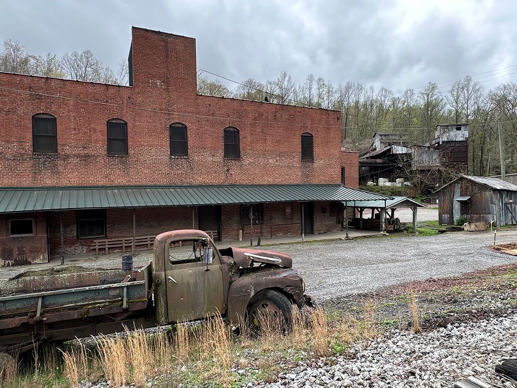
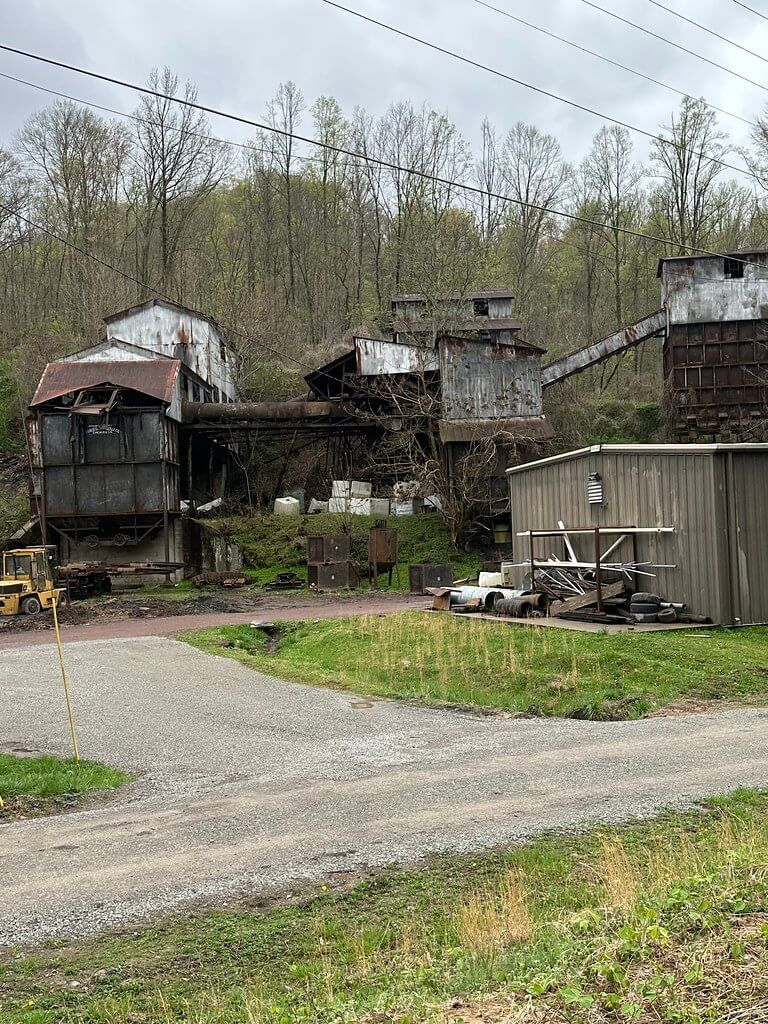
Primary company-era traces for Kitts begin to accumulate in the late 1910s and 1920s. A Caufield & Shook photograph set includes a “Clover Fork Coal Company, Clover Fork Mine, Kitts” survey view labeled “House #10,” a typical camp dwelling documented during operations. Federal court records in Clover Fork Coal Co. v. NLRB describe the company’s Harlan County estate at Kitts in matter-of-fact terms: roughly 2,000 acres total with about 1,250 acres in coal, a company tipple that sized the coal, and company-owned houses “in which most of its employees live.” Together, these records verify both the scale of the plant and the existence of a planned camp.
Company scrip from “Clover Fork Coal Co., Kitts, KY” survives in multiple denominations. Numismatic catalogs and sale records document Osborne-minted brass tokens marked “PAYABLE IN MERCHANDISE,” the everyday currency of a closed company economy that miners exchanged at the store. These artifacts ground the place-name and company name in contemporary metal.
Rails, roads, and the river
Kitts depended on Louisville & Nashville’s Clover Fork Branch, the east-running arm that left the Cumberland Valley main at Harlan Junction. Railroad guides and enthusiast track notes describe the branch’s post-war upgrades and list mines and loaders along its hollows into the 1940s. The corridor itself is sketched plainly on 1928 photographs of the Pineville-Harlan Road, a paved segment of the “Rhododendron Highway,” and appears as rail, road, and river in parallel on the 1954 USGS maps.
Hydrologically, the reach was and is measured. A USGS gage at “Clover Fork at Harlan, KY” provides a modern federal point of reference for the flow that powered log drives and carried mine fines downstream. The river context helps orient the Kitts confluence in the larger Cumberland system.
Life and labor on the Clover Fork
The fabric of the county seat that provisioned camps like Kitts appears on Sanborn Fire Insurance maps of Harlan for 1919 and 1925. Those sheets show depots, yards, mills, and mine-supply houses arranged around the L&N lines, a durable urban template for coal distribution. Enumeration District maps prepared for the 1950 census add an official federal base for the same transport geography, with boundaries called out along the Clover Fork and the L&N Railroad. The population schedules for Harlan County EDs complete the picture at the household level.
Labor relations at Kitts enter the public record through the Sixth Circuit’s opinion in Clover Fork Coal Co. v. NLRB, which fixes the company’s footprint and describes its company housing and tipple. That case sits within Harlan County’s well-documented labor conflicts, but it is valuable here as a precise, named snapshot of Kitts in operation.
Rocks, roots, and an upright forest underground
Geology anchored Kitts as much as rails did. The USGS geologic map of the Harlan quadrangle (GQ-1015, 1972) and KGS’s digitized county geology show the Sewanee-to-Harlan sequence of Pennsylvanian coals and sandstones that miners worked on Clover Fork. In 1938 miners at a Clover Fork Coal Company mine near Kitts uncovered upright fossil tree stumps. The Kentucky Geological Survey later conserved and interpreted those stumps for public display, tying the Kitts mines into a deep-time story older than the valley itself.
After coal
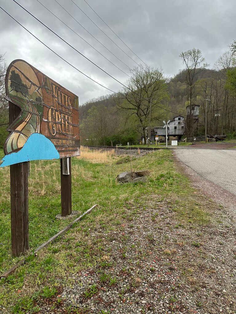
By mid-century Kitts’s primary extraction era waned, a trajectory seen across Harlan County. Secondary documentation compiled by field photographers confirms that the Clover Fork Coal Company’s visible plant survived into the twenty-first century as industrial ruins and repurposed structures. Meanwhile, state and county map portals record a new kind of “Kitts Creek” enterprise at the same highway address, a small forestry products firm listed in business directories and state search portals. The continuity of the place-name speaks to a landscape where streams and roads outlast owners.
Where to find Kitts on the map today
Researchers can place Kitts precisely by pairing the 1954 Harlan and Evarts quadrangles with GNIS coordinates for Kitts Creek. KGS’s county geology and the Mine Mapping Information System add mined-out extents and seam attributions. Together the federal and state map layers let you walk the hollow on screen before you set foot on Highway 3454.
Sources and further reading
USGS historical topographic map, Harlan 7.5′ quadrangle, 1954. Downloadable GeoPDF. U.S. Geological Survey. The National Map
Geologic map of the Harlan quadrangle (GQ-1015), 1972. A. J. Froelich and E. J. McKay. USGS. PDF via KGS and USGS. kgs.uky.edu+1
GNIS feature record, Kitts Creek. U.S. Board on Geographic Names. Coordinates and map placement. Topo Zone
USGS Water Data, Clover Fork at Harlan, KY (03400990). Flow records for the reach serving Kitts. USGS Water Data
DPLA: “Clover Fork Coal Company, Clover Fork Mine, Kitts, Harlan County, Kentucky. View of House #10 surveyed.” Contemporary camp photo. Digital Public Library of America
Sanborn Fire Insurance Maps, Harlan (1919 and 1925). Urban industrial layouts feeding the Clover Fork corridor. digital.library.louisville.edu+1
1950 Census Enumeration District map and descriptions, Harlan County (ED 48 series). NARA scans and index. Wikimedia Commons+1
Clover Fork Coal Co. v. NLRB, 97 F.2d 331 (6th Cir.). Federal appellate case naming the Kitts operation, acreage, tipple, and company housing. Justia
Clover Fork Coal Co. scrip, Kitts, KY. Token descriptions and sale records. Osborne Coinage issues documented in numismatic catalogs. en.numista.com+1
Kentucky Geological Survey. County geology and land-use planning notes for Harlan County, with digitized quadrangle data derived from USGS mapping. kgs.uky.edu
KGS: “Upright fossil tree stumps (public display)”. Summary of 1938 recovery from a Clover Fork Coal Co. mine near Kitts. University of Kentucky
Oxford American / EHRP, “The Ballad of Harlan County” (2016). Context on the Whitfield family and the founding of Clover Fork Coal Co. at Kitts Creek. Oxford American
CoalCampUSA: “KITTS, KY.” Photo essay identifying the Clover Fork tipple and company store remnants. coalcampusa.com
University of Louisville Digital Collections. “Harlan, ‘The Hub City,’ 1928” aerial and related Clover Fork corridor views. digital.library.louisville.edu+1