Appalachian History Series – The Oldest House in Bell County: Rev. John C. Colson’s Brick Home on Yellow Creek
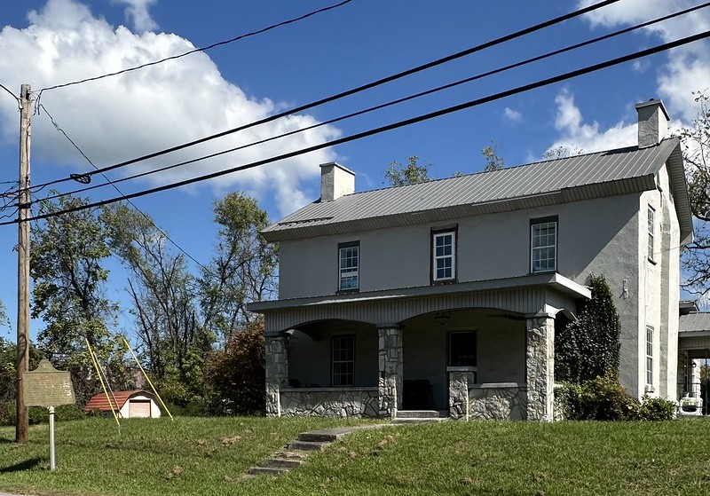
If you drive up North 19th Street in Middlesboro, traffic hums past a modest brick house set back behind a yard and a low slope. The building does not announce itself loudly. Its lines are simple, two stories of brick with later stucco and porch alterations that make it easy to mistake for an ordinary early twentieth century home. What gives it away is the green and gold roadside marker in the grass.
That marker, installed by the Kentucky Historical Society as Marker 1228, calls this place simply the “Oldest House.” It records that the dwelling was built about 1800 in Yellow Creek Valley, that it was the second brick house in what became Bell County and is now the oldest one still standing, and that its bricks were made from local clay by enslaved laborers. It identifies the home as that of Rev. John Calvin Colson, whom it remembers as “Patriarch of Yellow Creek Valley,” and lists his occupations in a tumble: preacher, teacher, lawyer, doctor, farmer, miller, merchant.
Today the house is a private residence. Visitors see it from the sidewalk or from behind a car window, often pausing only long enough to read the sign and snap a photograph before heading on toward Cumberland Gap or downtown Middlesboro. Travel guides and review sites list it as a minor point of interest, usually with a sentence or two about its age and a note that you can only view it from the street. Yet this quiet brick house predates the “Magic City” that rose around it by nearly a century. To understand its story is to remember that Yellow Creek Valley had its own deep history long before British capital, streetcars and iron furnaces transformed the basin into Middlesborough.
Yellow Creek Valley before the Magic City
Most modern visitors encounter Yellow Creek Valley as a city. Highways, canalized water, and the wide floor of the Middlesboro Basin frame their view. In the late eighteenth and early nineteenth centuries, however, this valley was a rural landscape of bottomland fields and scattered houses along the route to Cumberland Gap.
Local tradition holds that one of Kentucky’s earliest recorded explorers, Dr. Thomas Walker, passed through what is now Bell County in 1750 and carved “A. Powell 1750” on a beech tree in Yellow Creek Valley. Though the original tree is long gone, the story survived in county memory and helped fix the valley’s role in the story of the Wilderness Road. The old trace from the ford at Cumberland Ford (Pineville) to Cumberland Gap followed the narrow bottoms of the river and the creek, climbing and descending where the terrain allowed. Yellow Creek’s valley floor, which would later hold streets and a canal, was for decades a corridor of farmsteads and cornfields seen by thousands of migrants on their way west.
One of the people who saw that valley in its in–between state was a boy named Henry Harvey Fuson. Writing his History of Bell County in the 1940s, Fuson looked back to around 1880, when his father carried him across Yellow Creek to visit relatives. He remembered wide corn and wheat fields and only “three large houses” in the valley: the Rev. John C. Colson brick house across from what is now Middlesboro Cemetery, the Jack Mealer house, and the home of Colson’s son nearer the foot of Cumberland Mountain. It is a simple memory, but it fixes the Colson House as an established landmark even before the “Magic City” boom.
When Alexander Arthur and his investors descended on Yellow Creek in the late 1880s, they were not building on untouched ground. County histories, planning reports, and later studies all point out that Arthur’s project took a rural farming valley and overlaid it with speculative urbanism. Streets with English names, an electric streetcar, a golf course, and a canalized creek appeared within a few years. Amid all that change, the Colson House and a handful of other older dwellings stayed put, becoming some of the last visible pieces of the pre–boom landscape.
Building a brick house with local clay and enslaved labor
The Colson House is unusual in Bell County partly because of its age and partly because of its material. Most early dwellings in the region were log or frame. Brick required skilled labor, a kiln, and enough capital to justify the expense. Marker 1228 notes that the house was built around 1800, that it was only the second brick house erected in the county, and that its bricks were made from nearby clay by enslaved workers.
Those details open a window into the social world that produced the building. By 1800, slavery was firmly entrenched in Kentucky, including its Appalachian counties, though the enslaved population in the mountains was smaller than in the Bluegrass. Brickyards in the early republic often relied on enslaved artisans who dug clay, tempered it, molded bricks, and stacked them in clamp kilns. The marker’s plain acknowledgement that the Oldest House was built with bricks made by slave labor brings that reality to the surface in a region where the story of slavery is sometimes overshadowed by later coal and industrial narratives.
Modern reference works and local summaries add another piece: they credit the initial construction to a Mr. Hunter, an early settler whose brick house stood in Yellow Creek Valley before being purchased by the Colson family. Whatever the precise chain of title, by the middle of the nineteenth century the brick dwelling had become the home base of one of the valley’s most influential residents.
Rev. John Calvin Colson and a crossroads community
Rev. John Calvin Colson was born in 1822 in what was then Claiborne County, Tennessee, just across the state line from Cumberland Gap. By the time he reached middle age he had migrated into what would become Bell County. Early in his life he lived along Cannon Creek. Later he acquired property in Yellow Creek Valley at a spot that would sit squarely in the path of Middlesborough’s future town grid.
Fuson’s county history, written by a man who had known Colson in his youth, paints a vivid portrait. Colson, he says, was “gifted along these lines” and turned his hand to nearly everything a rural community needed. He preached, taught school, practiced a rough frontier medicine, read law, farmed, and ran both a grist mill and a general store. The historical marker compresses that life into a single sentence that lists his occupations one after another, like a roll call of the roles that made a valley function.
Colson’s store, according to Fuson, stood in front of the brick residence. A horse powered mill stood nearby on Yellow Creek, grinding grain for neighbors who otherwise had to haul their wheat and corn considerable distances. Between roughly 1830 and 1889, Fuson notes, only three general stores served Yellow Creek Valley. One of them was Colson’s. People came there not only to buy goods, but also to get their mail, trade news, and settle disputes.
Genealogical records and cemetery listings help fix Colson’s life in time and space. They record his birth in 1822, his marriage into local families, and his death in 1882. His grave lies in Middlesboro Cemetery across the road from the house, a physical reminder of the connection between the dwelling and the family who gave it its lasting name. Later generations of Colsons, including David Grant Colson, who became a U.S. Congressman and Spanish American War officer, grew up in Yellow Creek Valley, and some accounts identify the old brick house as his boyhood home.
To later Bell Countians, Colson’s combination of roles and his long presence on the land made him a kind of patriarch. The marker uses that word explicitly. It is not hard to imagine why. For much of the nineteenth century, anyone traveling between the Gap and the county seat at Pineville passed his door.

On the Wilderness Road and the old county road
Geography helps explain why this particular house became such a reference point. Yellow Creek’s valley provided one of the gentlest grades through the broken terrain between Pineville and Cumberland Gap. Long before there was a paved U.S. 25E or a Cumberland Gap Tunnel, the main road from the Kentucky interior climbed Log Mountain, turned into Yellow Creek Valley, and followed its bottomland toward the Gap and the Virginia and Tennessee lines.
A National Park Service report on the “Location of the Wilderness Road at Cumberland Gap” uses old deeds and court orders to reconstruct that route. In one early twentieth century Bell County order, the old county road is described as running “from the Virginia and Tennessee line at the Cumberland Gap, northly down the mountain to Jno. C. Colson house” before turning toward Pineville. The phrasing is telling. At a time when surveyors were trying to describe a stretch of road in relocatable terms, they chose the Colson House as a landmark.
Later, when new roads and even a tunnel shifted traffic patterns, Boone Trace and the Old Pineville–Middlesboro Road continued to shadow the same corridor. Heritage materials produced for the Cumberland Gap National Historical Park and for Boone Trace tour projects note that traveling north from the “Oldest House” in Middlesboro follows essentially the same route as that earlier trace along Yellow Creek.
Cartographic sources let us watch that landscape change in plan view. Sanborn Fire Insurance Maps for Middlesboro, produced between 1891 and 1923 and digitized by the Library of Congress, show the Yellow Creek bottom as it fills with streets, tracks, and buildings. Census enumeration maps for 1950, preserved by the National Archives and accessible through Wikimedia, do the same for the mid twentieth century, locating the house near the cemetery and the North 19th Street corridor within a fully incorporated town. Through those changes the Oldest House shifts from rural landmark to city edge dwelling to in town house on a busy street.
Middlesboro grows around the Oldest House
By the time Middlesborough was platted in 1888, the brick dwelling in Yellow Creek Valley had already stood for most of a century. Arthur’s investors envisioned a steel city of 250,000 residents, with English style streets, a grand hotel, and industries ringing the basin. For a time, the dream seemed plausible. Contemporary accounts and later studies describe millions of dollars in British capital pouring into the project. Railroads and the short lived Watts furnaces rose on the valley floor.
Then came setbacks. A devastating 1890 fire, cost overruns on the railroad and the first tunnel at Cumberland Gap, and the Panic of 1893 all hit the “Magic City” hard. Middlesborough did not vanish. It survived as a much smaller regional center, with a population that would peak around the mid twentieth century before sagging with coal’s decline. Through those cycles, the Colson House remained.
Modern planning and heritage documents created for downtown revitalization efforts still list the “Colson House (Oldest House in Bell County)” as one of the community’s key historic assets and map it alongside other features like the high school, canal, and U.S. 25E. Tourism oriented pieces, from local newspapers to travel blogs, mention it as a quick stop where you can see the oldest brick house in the county and read the marker before driving on to the Pinnacle Overlook or the national park.
This kind of modest visibility can cut both ways. On one hand, it keeps the house in public view and ties it to the Boone Trace and Wilderness Road story. On the other, it can flatten the building into a simple roadside curiosity, a box to check off between other attractions. The deeper story, which stretches from early slavery and brickmaking to boomtown speculation, is easy to miss if you only glance at the sign.
Layered histories in one yard
Stand on the sidewalk in front of the Oldest House and several historical layers intersect at your feet. Set back behind the yard is the brick fabric created by enslaved laborers and early valley settlers around 1800. In the cemetery across the way lie the Colsons and their neighbors. Their headstones mark lives that touched nearly every part of nineteenth century Yellow Creek society, from church and school to law and commerce.
Running just beyond the yard is the line of the old county road, successor to sections of the Wilderness Road and Boone Trace, along which countless migrants and local farmers passed through the Gap. The modern traffic that now uses North 19th Street and U.S. 25E follows a similar axis, although the biggest flows now bypass the house on a divided highway and through a tunnel under Cumberland Mountain rather than over the old crest.
Above and around everything is the broader story of Middlesboro itself. The boom and bust of the Magic City, the fires, the persistence of a smaller but resilient town, and the more recent efforts at revitalization all show up in the urban fabric that surrounds the house. In that sense, the Oldest House is not just a relic of the early republic. It is a vantage point from which to see how a rural valley became a speculative city, how that city survived its own failures, and how local people continue to negotiate which pieces of that layered history to remember and interpret.
Why the Colson House matters
For Bell County residents, the Colson House can feel familiar enough to fade into the background. It is just “the Oldest House,” a landmark you tell visitors to look for when giving directions, a place that shows up in local trivia and on the occasional brochure. Yet for Appalachian historians and for anyone interested in how landscapes remember their past, it is a rare survival.
Relatively few early brick houses remain in the eastern Kentucky coalfield counties. Even fewer stand in locations that tie them so directly to a major migration corridor like the Wilderness Road and to a later boomtown experiment like Middlesborough. The Colson House does both.
At the same time, the marker’s straightforward mention of enslaved labor and its description of Colson as a many sided community figure invite a more nuanced reading. The house was both a product of slavery and a center of local leadership. It sat in a valley that had seen Native travel, Long Hunter exploration, frontier settlement, migrant wagon trains, and eventually a speculative city financed from abroad. Each of those stories left traces. Some are written in brick and stone. Others survive in old maps, in county histories, and in the memories that people like Fuson chose to record.
For now the Oldest House remains a lived in dwelling, not a museum. That status limits public access, yet it also means the building continues to function as a home rather than a frozen exhibit. For visitors, the most respectful way to engage is to treat it as both: a private residence with a public history. For researchers and local storytellers, it offers a chance to connect the familiar phrase “Oldest House” to a richer set of questions about who built it, who lived there, who labored in its shadow, and how a brick house on Yellow Creek came to stand at the crossroads of so many Appalachian stories.
Sources & Further Reading
Sanborn Map Company. Sanborn Fire Insurance Map from Middlesboro, Bell County, Kentucky. Map, June 1901. Library of Congress, Geography and Map Division. https://www.loc.gov/item/sanborn03209_002/ Library of Congress Handle
Sanborn Map Company. Sanborn Fire Insurance Maps Collection. Library of Congress, Geography and Map Division. Overview and searchable database for additional Middlesboro sheets (1891, 1907, 1913, 1923). https://www.loc.gov/collections/sanborn-maps/about-this-collection/ The Library of Congress+1
Fuson, Henry Harvey. History of Bell County, Kentucky. Volume 1. New York: Hobson Book Press, 1947. PDF, Bell County Public Library District. https://www.bellcpl.org/uploads/4/2/6/7/42679073/history_of_bell_county_kentucky.pdf Bell County Public Library District+1
Kentucky Historical Society. “Oldest House.” Kentucky Historical Highway Marker 1228, Bell County. Marker database entry. https://secure.kentucky.gov/kyhs/hmdb/MarkerSearch.aspx?mode=County&county=7 Kentucky.gov+1
Kentucky Historical Society. “Oldest House.” ExploreKYHistory. Marker item page with narrative and images. https://explorekyhistory.ky.gov/items/show/413 Explore Kentucky History+1
“Oldest House.” Historical Marker Database (HMdb.org). Transcription of Kentucky Historical Marker 1228 and photographs, Middlesboro, Bell County, Kentucky. https://www.hmdb.org/m.asp?m=181081 HMDB+1
Krakow, Jere L. Location of the Wilderness Road at Cumberland Gap National Historical Park. Washington, DC: U.S. Department of the Interior, National Park Service, 1987. HathiTrust catalog entry. https://catalog.hathitrust.org/Record/002508326 Google Books+1
Torres-Reyes, Ricardo. Davis Tavern Site: Location Study, Cumberland Gap National Historical Park, Kentucky–Tennessee–Virginia. Washington, DC: Division of History, Office of Archeology and Historic Preservation, 1969. National Park Service History Collection. https://npshistory.com/publications/cuga/ls-davis-tavern.pdf NPS History+2WorldCat+2
“1950 Census Enumeration District Maps – Kentucky (KY) – Bell County – Middlesborough – ED 7-31 to 52 – NARA – 12058281.” Map. Record Group 29, Records of the Bureau of the Census, National Archives and Records Administration. Image via Wikimedia Commons. https://commons.wikimedia.org/wiki/File:1950_Census_Enumeration_District_Maps_-_Kentucky_(KY)_-_Bell_County_-_Middlesborough_-_ED_7-31_to_52_-_NARA_-_12058281.jpg Wikimedia Commons+2Wikimedia Commons+2
“Rev John Calvin Colson.” Memorial 11043457. Find a Grave. Middlesboro Cemetery, Middlesboro, Bell County, Kentucky. https://www.findagrave.com/memorial/11043457/john-calvin-colson Find a Grave+1
“John Calvin Colson (1822–1882).” FamilySearch Family Tree. https://ancestors.familysearch.org/en/9JWB-N9B/john-calvin-colson-1822-1882 FamilySearch+1
“Middlesboro Genealogy (in Bell County, KY).” LDSGenealogy.com. Directory of local records, including historical newspapers and maps. https://ldsgenealogy.com/KY/Middlesboro.htm LDS Genealogy+1
“Historical Markers – Bell County.” KYGenWeb. Listing of Bell County markers, including Oldest House (Marker 1228). https://kygenweb.net/bell/historical_markers.htm KyGenWeb
“Rev. John C. Colson House, Middlesboro, Kentucky (1800).” In “Colson House.” Wikipedia. https://en.wikipedia.org/wiki/Colson_House Wikipedia
“List of Historic Houses in Kentucky.” Wikipedia. Includes entry for “Colson House (Middlesboro) – Oldest remaining house in Bell County; built 1800.” https://en.wikipedia.org/wiki/List_of_historic_houses_in_Kentucky Wikipedia
“Middlesboro, Kentucky.” Wikipedia. General history and context for the city and Yellow Creek Valley. https://en.wikipedia.org/wiki/Middlesboro%2C_Kentucky Wikipedia
Vial, Rebecca. Cumberland Gap, Tennessee: Building Community Identity Along the Wilderness Road, 1880-1929. Master’s thesis, University of Tennessee, 1991. https://trace.tennessee.edu/utk_gradthes/5827 TRACE+2TRACE+2
University of Kentucky, Department of Landscape Architecture. Gateway to the Gap: Connecting Cumberland Gap National Historical Park and Middlesboro via the Boone Trace. Studio report, 2014. https://ukla.mgcafe.uky.edu/files/ukla_2014_middlesboro_gateway_to_the_gap_report_opt.pdf MGCafe+2MGCafe+2
Claiborne Progress. “INSIDER GUIDE 2021: Historic Downtown Middlesboro.” Claiborne Progress, September 29, 2021. https://claiborneprogress.net/2021/09/29/insider-guide-2021historic-downtown-middlesboro/ Claiborne Progress+1
“Oldest House in Middlesboro.” TripAdvisor. Attraction listing with current photos and visitor descriptions. https://www.tripadvisor.com/Attraction_Review-g60782-d8407056-Reviews-Oldest_House_in_Middlesboro-Middlesboro_Kentucky.html Tripadvisor+2Tripadvisor+2
Kentucky Farm Bureau. “The 120: Bell County.” Life’s Blueprints feature. Kentucky Farm Bureau Insurance. https://www.kyfb.com/insurance/lifes-blueprints/the-120-bell-county/ Kentucky Farm Bureau+2Kentucky Farm Bureau+2
“Kentucky’s Top 5 Historic Attractions.” Hertz Travel Blog, February 9, 2018. Includes driving route beginning at Historical Marker 1228 (Oldest House) and following the Wilderness Road corridor. https://www.hertz.com/us/en/blog/places-to-go/kentucky-top-5-historic-attractions https://www.hertz.com
Matheny, Ann Dudley. The Magic City: Footnotes to the History of Middlesborough, Kentucky, and the Yellow Creek Valley. Middlesboro, KY: Bell County Historical Society, 2003. Bookstore listing. https://www.bellcountyhistorical.org/product-page/the-magic-city-by-ann-dudley-matheny BellCountyHistorical+1
“Sanborn Maps: About This Collection.” Library of Congress Sanborn Fire Insurance Maps. Background on Sanborn map coverage and use. https://www.loc.gov/collections/sanborn-maps/about-this-collection/ The Library of Congress+1
“Sanborn Insurance Maps – An Overlooked Genealogical Resource.” LDSGenealogy.com. Methodological overview of using Sanborn maps to locate historic buildings. https://ldsgenealogy.com/Sanborn-Insurance-Maps-an-Overlooked-Genealogical-Resource.htm LDS Genealogy
Yelp. “The Oldest House in Middlesboro.” In “Top 10 Best Landmarks & Historical Buildings near Bell County, Kentucky.” https://www.yelp.com/search?cflt=landmarks&find_loc=Bell+County%2C+KY Yelp+1
Boone Trace 1775. “Boone’s Trace Overland Hiking Map.” Map PDF showing route and points of interest including Oldest House in Middlesboro. https://www.boonetrace1775.com/Maps/Hiking-Trail/BT-Overland-Hiking-Map-copy.pdf Boonetrace
Kentucky Farm Bureau. “The 120: Bell County.” In Life’s Blueprints digital magazine. Kentucky Farm Bureau News, August 2025 issue. https://editions.mydigitalpublication.com/publication/?i=850143 (navigate to “The 120: Bell County”). My Digital Publication+1
Stephens, Thomas E. Stephens. “Congressman David Grant Colson and the Tragedy of the Fourth Kentucky Volunteer Infantry.” The Register of the Kentucky Historical Society 98, no. 1 (Winter 2000): 43–102. Accessed February 10, 2026. https://kynghistory.ky.gov/Our-History/History-of-the-Guard/Documents/Col_Colson_4th_KY_s.pdf
Author Note: This little brick house has been part of my mental map of Yellow Creek for as long as I can remember studying Middlesboro. I hope this piece helps you see more than a roadside marker and invites you to picture the lives and labor that made the “Oldest House” stand where it is today.
Very interesting. I’ve researched the family for many years (JCC Sr. was a 3-g-grandfather), but know little about the house. Thanks!