Abandoned Appalachia
Where is “Tunnel Hill”?
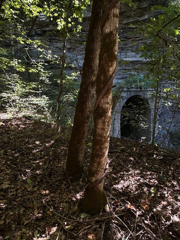
Locals use Tunnel Hill for the crest above a pair of side-by-side railroad bores just northwest of Hazard. On the maps the spot falls within the unincorporated community historically called Dunraven. A quick way to pin it on the ground is the county’s own road index, which lists Tunnel Hill Cemetery in Dunraven. That listing sits directly over the bores, and it remains the most practical local-government breadcrumb for finding the site from county roads.
What the primary maps show
The twin tunnels lie on the USGS Krypton, Kentucky 7.5-minute quadrangle that covers Hazard’s northwestern approach. Multiple editions of the sheet mark the railroad and tunnel symbols at Tunnel Hill. The modern US Topodownloads for 2013 and 2016 show the bores, tracks, and nearby river bends; the sheet’s index also places the site within the Krypton grid.
The Krypton quad’s Gazetteer is especially useful because it lists the area’s named railroad tunnels that appear on these sheets. On Krypton you will find entries for Campbell Tunnel, Typo Tunnel, Yerkes Tunnel in Perry County, plus Line Tunnel on the same quad in neighboring Breathitt County. The gazetteer’s Krypton page also provides convenient links to each historical or current edition of the map.
USGS GNIS-backed records fix precise coordinates for several of these bores. For example, Yerkes Tunnel appears at about 37.28509, −83.30601 on the Krypton sheet, and Typo Tunnel centers near 37.27454, −83.26157. These entries confirm the features, their map association, and their tunnel classification.
The line through Hazard and its long bores
Hazard’s railroad is famous for tunnels. A century after the Louisville and Nashville drove its line up the North Fork, you can still see portals right at town. One short example is the Hazard Yard South Tunnel, photographed and described by a regional railroad historian as about 450 feet long, with an adjacent truss over the river. That snapshot helps explain why the area sprouted multiple short bores where the tracks hug the river and thread ridges.
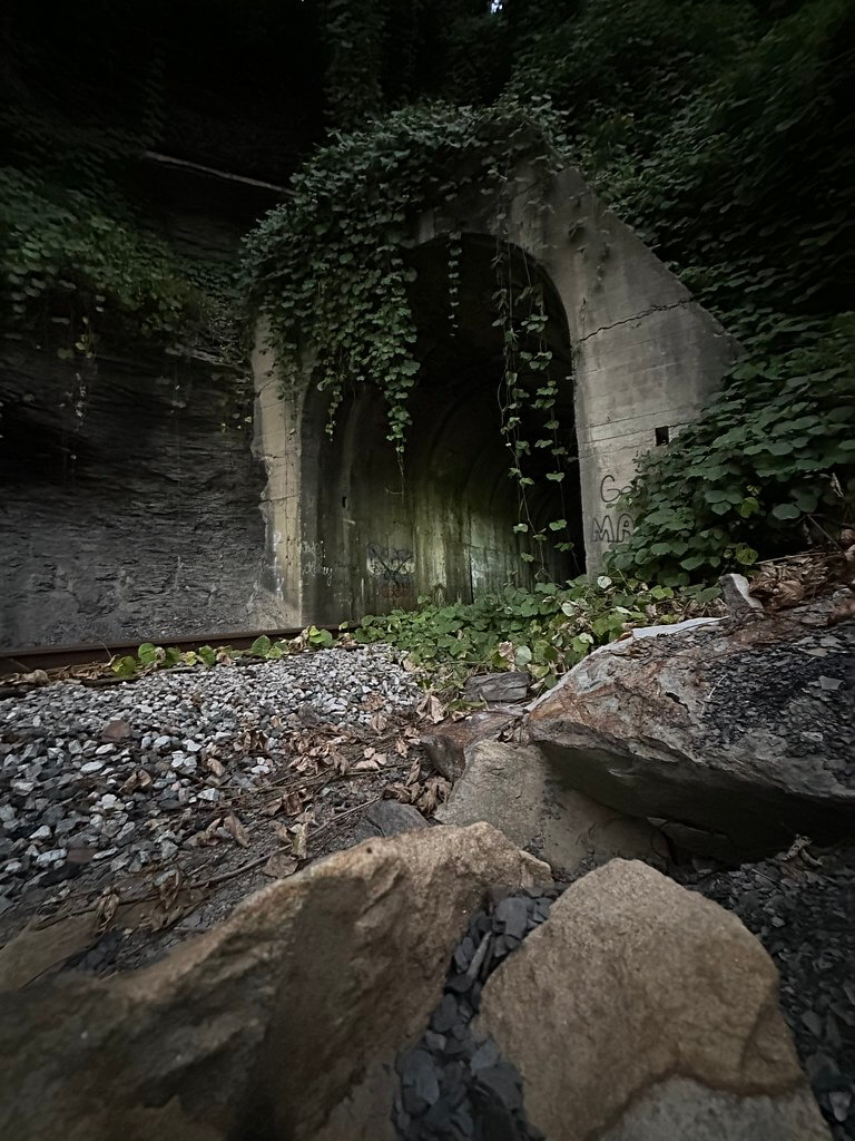
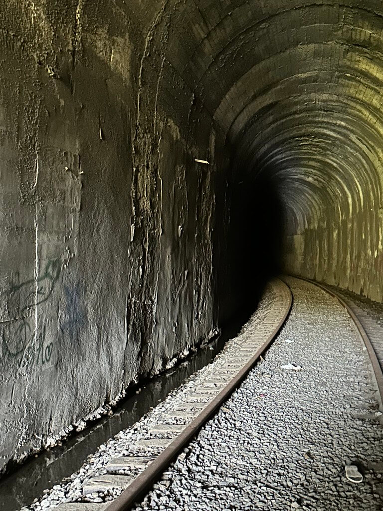
The tunnel pair at Tunnel Hill functions like a two-track choke point where the railroad passes through a narrow ridge above the river. Modern railfan and infrastructure inventories confirm that working railroad structures remain clustered nearby, including bridges and the “Hazard Tunnel” listing on engineering reference sites. These items corroborate an active corridor in the immediate vicinity.
Regulation and recent status
In December 2016, CSX Transportation filed for a discontinuance of service exemption over roughly 3.3 miles of the EK Subdivision at Hazard, between milepost 0WV 242.0 and 0WV 245.3. The Surface Transportation Board notice is the primary federal record for the segment’s recent regulatory posture. A discontinuance is not the same thing as an abandonment, but it marks a change in service and is often cited in state rail-corridor summaries.
The Kentucky Transportation Cabinet’s Abandoned Railroad Corridor Inventory uses STB dockets like AB-55 to document corridor status and preservation steps statewide. For visualization, the STB Map Depot publishes federal layers that display active and discontinued lines in Perry County, which helps place the Tunnel Hill corridor within the broader system.
“Dunraven,” “Tunnel Hill,” and the old habit of naming for tunnels
“Dunraven” shows up in GNIS-derived references as the historic settlement name for the hill above the bores. The local nickname “Tunnel Hill,” preserved in county records and community use, simply describes what was built there.
That habit of naming around tunnels runs all along this line. One of Hazard’s river-bend stations was even called Lennut which is “tunnel” spelled backward. Contemporary sources explain that postal officials rejected the simple word “Tunnel” for a post office name, so the camp and station flipped the letters. The entry places the station about 500 yards from a railway tunnel on the route into town.
On-the-ground confirmation
Community documentation also ties the Dunraven name to the twin bores. A long-running geocaching page calls the site “Twin Tunnels,” explicitly notes that locals call the hill Tunnel Hill, and provides directions to view the pair from a public road. Multiple walk-through videos posted online likewise show two adjacent portals in the Hazard area, with additional bores visible down toward Yerkes. These sources are not primary in the archival sense, but they are valuable for confirming what the maps and gazetteers show. Please observe railroad safety and property lines.
Why the twin bores are there
The North Fork carves a tight valley through resistant Pennsylvanian sandstones and shales. Where a ridge abuts the river and there is no room to swing a broad curve, short tunnels and short bridges alternate to keep a line at a practical grade. The Krypton quads depict exactly that pattern at Dunraven, Yerkes, and Typo. A century of coal traffic left Perry County with a dense micro-geography of portals, trestles, and yards, and Tunnel Hill’s twin bores are a compact example of how railroads solved Appalachian terrain.
Visiting notes
If you go to look, use county roads and public vantage points listed in the road index and modern maps. Do not enter tunnels or railroad right-of-way. Trains can be quiet on approach, and active status can change without notice. The STB map and recent USGS US Topo sheets can help you plan a safe and lawful view from public places.
Sources and further reading
USGS Krypton, KY 7.5-minute maps. Free downloads of 2013 and 2016 show the Tunnel Hill portals, adjacent tracks, and river bends. TNM+1
YellowMaps Krypton Gazetteer. Lists Campbell Tunnel, Line Tunnel, Typo Tunnel, Yerkes Tunnel on the Krypton quadrangle, with links to multiple map editions. YellowMaps
GNIS derived coordinates. Yerkes Tunnel at ~37.28509, −83.30601; Typo Tunnel at ~37.27454, −83.26157. TopoQuest+1
Surface Transportation Board, Federal Register. CSX Transportation, Inc. Discontinuance of Service Exemption, Docket AB 55 (Sub-No. 767X), Dec. 16, 2016 (about 3.3 miles at Hazard). GovInfo
Kentucky Transportation Cabinet. Kentucky Abandoned Railroad Corridor Inventory (state overview that references STB abandonments and preservation). Kentucky Transportation Cabinet
STB Railroad Map Depot. Interactive layers for active, discontinued, and rail heritage lines in Perry County.
Perry County Road Index. Local government index that includes Tunnel Hill Cemetery at Dunraven, which sits over the bores.
Dunraven, Kentucky (GNIS-backed settlement stub for location context). Wikipedia
North Fork tributaries at Hazard (discussion of Lennut “tunnel” reversed, and other station names along this line). Wikipedia
Blogging the Railroad Tunnels. “Hazard Yard South Tunnel” (photo and description of a short L&N bore by Hazard Yard). Blogging the Railroad Tunnels
HistoricBridges.org. Perry County listings including “CSX – Hazard Tunnel” and nearby river crossings. Historic Bridges
Geocaching. GCYVK3 “Twin Tunnels.” Local naming, directions, and notes on the twin portals at Tunnel Hill. Geocaching
Video walk-throughs. “Twin train tunnels Hazard KY,” plus additional portals toward Yerkes. YouTube+1
Author Note: Thanks to Emily J for the suggestion by email. I visited twice at day and night… it did not disappoint. We may go back at some point.