Appalachian History Series – Kitts on Clover Fork: The Coal Camp at the Mouth of Kitts Creek
Kitts was never a large city, and it was not meant to be one. It grew in the tight valley east of Harlan where Kitts Creek came down to the Clover Fork of the Cumberland River. Like so many Harlan County coal places, its story begins with water, rail, coal, and a narrow piece of land where houses, tracks, mine openings, and company buildings had to fit between the stream and the mountain.
The place was close enough to Harlan to be tied to the county seat, but it belonged to a different kind of geography. Harlan had the courthouse, stores, offices, and railroad connections. Kitts had the mine. The distance was short on a map, but life in a coal camp had its own rules, its own routines, and its own center of gravity. The company, the tipple, the commissary, the houses, the road, and the mine mouth shaped daily life more directly than the county seat did.
The name Kitts survives because the creek survives. In the records, it appears beside the names of coal companies, mine inspectors, rail lines, legal cases, water systems, and later field photographs. Taken together, those sources show that Kitts was more than a dot beside Harlan. It was one of the small but important coal places that made the Clover Fork valley a working corridor of eastern Kentucky coal.
The Mines at Kitts
State mine records from 1920 give one of the clearest early snapshots of Kitts. The Kentucky State Department of Mines listed Kitts Creek Coal Company at Kitts, in Harlan County, on the Louisville and Nashville Railroad, about one mile from Harlan. The mine was described as a drift mine working the Harlan seam of coal. The seam was reported as about fifty inches thick, free from parting, with slate and sandstone roof.
The report also gives a sense of the scale and methods of work. Kitts Creek Coal Company was not described as a giant operation. It used mule haulage, loaded mine-run coal, and had a daily capacity of about fifty tons. The inspector noted that the mine had been driven into the Clover Fork mine and was ventilated by that company’s fan. That small detail is important. It places Kitts Creek Coal Company beside the larger Clover Fork operation and shows how closely the mines, openings, and company systems could be connected in the same valley.
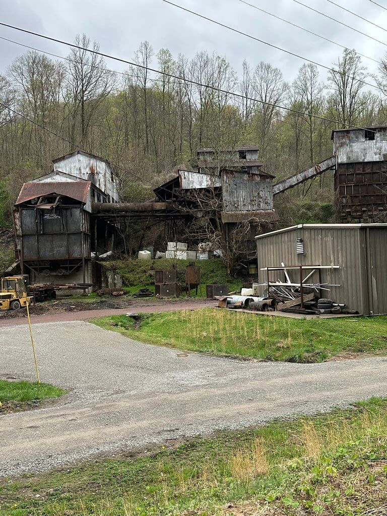
The larger name at Kitts was Clover Fork Coal Company. In the same 1920 mine report, Clover Fork Coal Company’s Clover Fork Mine was listed with B. W. Whitfield as general manager and president, John Surgener as superintendent, and E. T. Baker as mine foreman. Its main and mine offices were at Kitts. The Clover Fork Mine was also a drift mine working the Harlan seam. The report described a fifty-four-inch coal seam, electric haulage, Sullivan mining machines, Westinghouse and Jeffrey motors, a gravity plane, Webster shaker screens, and three grades of coal loaded as nut, lump, and slack. Its stated capacity was eight hundred tons per day.
Those details show the difference between a small hillside operation and a developed company mine. The Kitts Creek mine appears in the record as a smaller working place tied closely to the larger operation. Clover Fork Coal Company appears as the main industrial force at Kitts, with the equipment, rail connection, tipple, power, and company structure needed to make the camp last.
Another 1920 entry listed Golden Ash Coal Company’s Golden Ash Mine at Kitts. It, too, was on Clover Fork and the L&N Railroad, and it worked the Harlan seam. That record helps explain why Kitts should be understood as a coal district rather than a single mine opening. The place-name gathered several operations, but Clover Fork Coal Company became the best documented company connected to the camp.
A Company Camp on the Clover Fork
A coal camp was not simply a mine with houses nearby. It was a built environment shaped by ownership. At Kitts, the strongest evidence for that company-built world comes from federal court records, mine records, water records, and photographs.
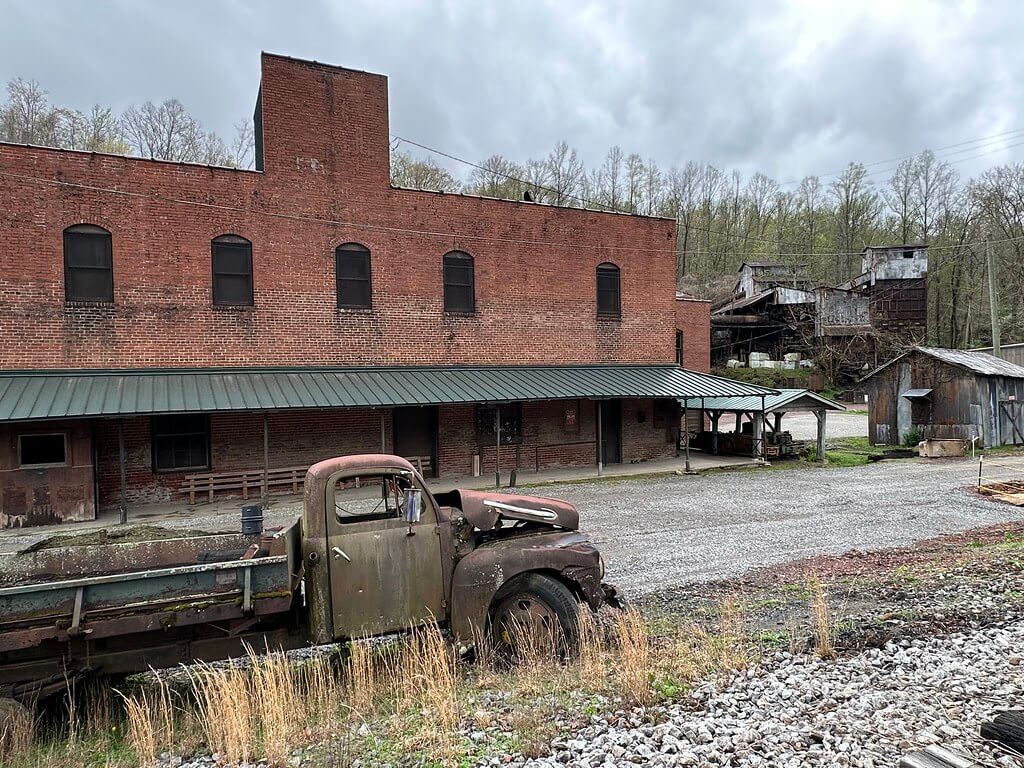
In 1938, Clover Fork Coal Company appeared before the United States Court of Appeals for the Sixth Circuit in a labor case involving the National Labor Relations Board. The court described the company as a Kentucky corporation mining coal at Kitts, Harlan County. It said the company owned about 2,000 acres in Harlan County, including about 1,250 acres of coal land. It also owned and operated the mine, the equipment, the tipple that separated coal into sizes, and the houses where most of its employees lived.
That description is plain, but it says a great deal. A company that owned the mine, tipple, equipment, land, and houses was not only selling coal. It was shaping the community around the coal. The miner’s workplace and the miner’s home were tied to the same owner. The rail cars that left the tipple carried coal to markets beyond the mountains, but the camp itself remained fixed in the narrow valley where families lived close to the mine.
Photographs connected to Clover Fork Coal Company show that world at ground level. Public image records identify houses at the Clover Fork Mine camp in Kitts, including surveyed houses, a road through the camp, a water tap, and refuse along the river. These images are valuable because they show the camp as a lived place, not just an industrial listing. The mine report tells us about seam height, haulage, screens, and tonnage. The photographs remind us that families lived in the company houses, drew water, walked the road, and made their lives along the same river that carried the name Clover Fork.
Water, Houses, and Daily Life
By the early 1950s, Kitts still had enough people and infrastructure to appear in a federal water-supply report. The United States Geological Survey listed Kitts with a population served of 600. The waterworks were owned by Clover Fork Coal Company. The source was one mine southeast of Kitts, with water-bearing strata in coal and Pennsylvanian rocks. The water was chlorinated before entering the distribution system.
The report covered water use from June 1, 1952, to January 2, 1953. During that period, the total distribution was listed at 59,659,000 gallons, with an average daily pumpage of about 276,000 gallons. The report also noted that water from the mine passed through the chlorinator to the distribution system and that per capita consumption was high, possibly because the water was supplied free.
That one technical entry opens a window into camp life. Water was not just a household matter. It was a company system. The same coal seam that drew miners underground also supplied water to the people living around the mine. The report shows Kitts as a functioning settlement with company water, company houses, and a population still tied to the mine in the middle of the twentieth century.
Company-store life also survives in fragments. Scrip associated with Clover Fork Coal Company at Kitts appears in coal-company token records and collector catalogs. Scrip was part of the company-town economy, a reminder that wages, store credit, household goods, and company control often overlapped. The surviving commissary and company buildings described by later field photographers add another layer to that story. They point to Kitts as a place where the industrial and domestic worlds stood almost side by side.
Labor Conflict at Kitts
Kitts also belongs to the larger labor history of Harlan County. In the 1930s, Harlan County became nationally known for coalfield conflict, union organizing, company resistance, federal investigations, and court cases. Clover Fork Coal Company was part of that world.
The 1938 federal court case grew from National Labor Relations Board action involving District 19 of the United Mine Workers of America. The court opinion said Clover Fork Coal Company produced about 300,000 tons of coal a year and employed about 240 men in mining, sorting, and loading operations. The coal was delivered from mine tracks and tipple to Louisville and Nashville Railroad cars, with most of it moving into interstate commerce.
The labor issue centered on union activity and alleged unfair labor practices. The court described efforts to unionize the company’s employees and the company’s resistance. The opinion refers to the discharge of men who had joined the union and to the company’s argument that nonunion employees had acted on their own. Whatever side of the legal argument one follows, the case places Kitts squarely inside the federal labor history of the New Deal coalfields.
That matters because Kitts was not an isolated hollow outside history. It was tied to the L&N Railroad, national coal sales, federal labor law, and the United Mine Workers. The houses at Kitts were local. The tipple stood in Harlan County. But the coal moved outward, and the labor struggle drew attention from Washington, Cincinnati, and the federal courts.
A Fossil Forest in the Mine Roof
One of the most unusual pieces of Kitts history came from the roof of the Clover Fork mine. In 1938, a large fossil tree stump was recovered from the Clover Fork Coal Company mine near Kitts. The Kentucky Geological Survey later identified it as a fossil lycopod tree stump with roots, found above the Harlan coal bed in the Pikeville Formation of the Breathitt Group.
The stump became known as the Whitfield stump. According to the Kentucky Geological Survey, George Whitfield managed the mine at the time and arranged for the several-ton fossil to be removed. It was first displayed at Kitts, then donated to the University of Kentucky in 1961. Its story connects coal mining to a much older landscape. The same mine that employed Harlan County workers also opened a window into the Pennsylvanian world that formed the coal itself.
That detail gives Kitts a deeper history than a normal camp record can show. The coal seam was not only an economic resource. It was the compressed remains of ancient environments. In Kitts, miners working a twentieth-century industrial mine uncovered a fossil from a forest hundreds of millions of years old.
What Remains of Kitts
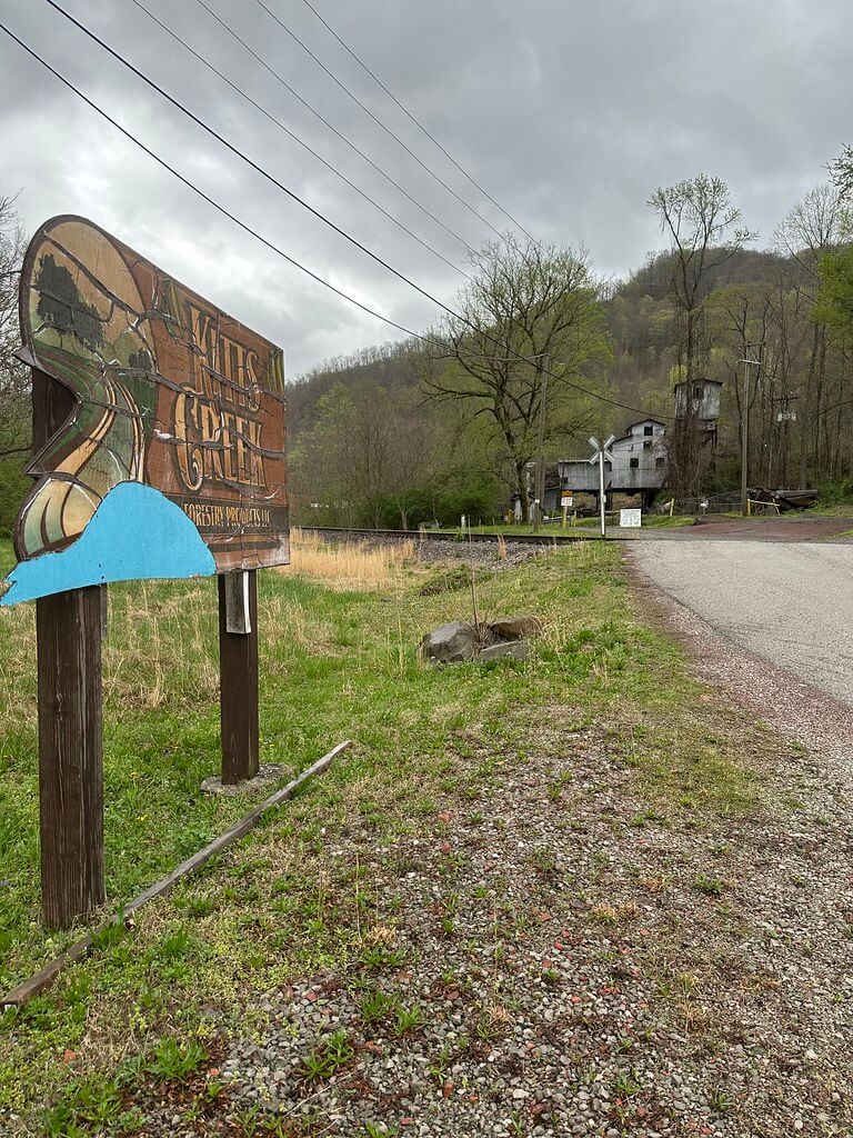
Later photographs and coal-camp documentation show that much of the camp was eventually lost, but not everything disappeared. CoalCampUSA’s Kitts page identifies surviving or formerly surviving industrial features associated with Clover Fork Coal Company, including the company store, tipple, bath house, commissary sign, and mine buildings. The page states that Clover Fork Coal Company operated the mine at Kitts from 1914 until 1958.
Modern views of Kitts are therefore not just ruins. They are evidence. A company store wall, an old sign, a tipple frame, a bath house, or a road trace can speak when paired with records from the Department of Mines, the USGS, the NLRB, and the courts. The physical remnants help place the written sources back on the land.
Kitts is easy to overlook because it stood so close to Harlan. Larger towns and better-known camps often take more attention. Yet the record for Kitts is unusually rich. Mine inspectors described the work underground. Federal courts described the company’s acreage, houses, production, and labor dispute. Water engineers recorded the camp’s company water system. Photographs preserved the houses, road, water taps, and riverbank. Geologists preserved the story of a fossil stump taken from the mine roof.
Together, those records show Kitts as a small place with a large paper trail. It was a coal camp at the mouth of a creek, a company settlement on the Clover Fork, and a working piece of Harlan County’s coalfield history. Its story is not only about what was mined from the mountain. It is also about the people who lived along the river, the company systems that shaped their daily lives, and the records that still let the place be seen.
Sources & further reading
Kentucky Department of Mines. Annual Report of the Department of Mines of Kentucky for the Year 1920. Frankfort: Kentucky Department of Mines, 1921. https://archive.org/details/annualreport41deptgoog
Kentucky Department of Mines and Minerals. Annual Report of the Department of Mines and Minerals of Kentucky for the Year 1924. Frankfort: Kentucky Department of Mines and Minerals, 1925. https://books.google.com/
Kentucky Department of Mines and Minerals. Annual Report of the Department of Mines and Minerals of Kentucky for the Year 1925. Frankfort: Kentucky Department of Mines and Minerals, 1926. https://books.google.com/
Daniel, Harry Thomas. Annual Report of the Department of Mines and Minerals of Kentucky for the Year 1928. Frankfort: Kentucky Department of Mines and Minerals, 1929. https://kgs.uky.edu/kgsweb/olops/pub/general/DanielReportMines1928.pdf
Clover Fork Coal Co. v. National Labor Relations Board, 97 F.2d 331. United States Court of Appeals for the Sixth Circuit, 1938. https://law.justia.com/cases/federal/appellate-courts/F2/97/331/1550170/
National Labor Relations Board. “In the Matter of Clover Fork Coal Company and District 19, United Mine Workers of America.” Decisions and Orders of the National Labor Relations Board 4, November 27, 1937, 202–241. https://www.nlrb.gov/cases-decisions/decisions/board-decisions
Cornell University Kheel Center. “Clover Fork Coal Company.” NLRB Briefs, Petitions, and Other Legal Documents, 1938, Box 2, Folder 45. https://rmc.library.cornell.edu/EAD/htmldocs/KCL05642.html
Baker, J. A., and W. E. Price. Public and Industrial Water Supplies of the Eastern Coal Field Region, Kentucky. U.S. Geological Survey Circular 369. Washington, DC: United States Government Printing Office, 1956. https://pubs.usgs.gov/circ/1956/0369/report.pdf
Baker, J. A., and W. E. Price. “Public and Industrial Water Supplies of the Eastern Coal Field Region, Kentucky.” U.S. Geological Survey Publications Warehouse. Accessed May 29, 2026. https://pubs.usgs.gov/publication/cir369
United States Geological Survey. Harlan Quadrangle, Kentucky. 1954. https://ngmdb.usgs.gov/topoview/
United States Geological Survey. “Geographic Names Information System.” Accessed May 29, 2026. https://www.usgs.gov/tools/geographic-names-information-system-gnis
Froelich, A. J., and E. J. McKay. Geologic Map of the Harlan Quadrangle, Harlan County, Kentucky. Washington, DC: U.S. Geological Survey, 1972. https://ngmdb.usgs.gov/Prodesc/proddesc_9749.htm
Kentucky Geological Survey. “Harlan County Geologic Map Information.” University of Kentucky. Accessed May 29, 2026. https://www.uky.edu/KGS/
Kentucky Geological Survey. “The Whitfield Fossil Tree Stump.” ArcGIS StoryMaps, January 23, 2024. https://storymaps.arcgis.com/stories/9eff42a754d242ecb805df5fa6f54924
Kentucky Geological Survey. “Upright Fossil Tree Stumps in Kentucky.” University of Kentucky. Accessed May 29, 2026. https://www.uky.edu/KGS/fossils/fossil-tree-stumps-public-display.php
Clover Fork Coal Co. v. Washington, 247 Ky. 848, 57 S.W.2d 994. Kentucky Court of Appeals, 1933. https://case-law.vlex.com/
Library of Congress. “Clover Fork Coal Company, Clover Fork Mine, Kitts, Harlan County, Kentucky.” Historic American Engineering Record and related photographic records. Accessed May 29, 2026. https://www.loc.gov/
Picryl. “Clover Fork Coal Company, Clover Fork Mine, Kitts, Harlan County, Kentucky.” Accessed May 29, 2026. https://picryl.com/topics/harlan%2Bcounty/coal%2Bmining
National Archives and Records Administration. “Clover Fork Coal Company, Clover Fork Mine, Kitts, Harlan County, Kentucky.” Public domain photographic records. Accessed May 29, 2026. https://catalog.archives.gov/
Rennick, Robert M. “Harlan County: Post Offices.” Morehead State University ScholarWorks, 2004. https://scholarworks.moreheadstate.edu/cgi/viewcontent.cgi?article=1384&context=kentucky_county_histories
TIME. “National Affairs: Happy Harlan.” TIME, 1937. https://time.com/
United States Congress. Congressional Record. Washington, DC: Government Printing Office, 1937–1938. https://www.govinfo.gov/app/collection/crecb
Hevener, John W. Which Side Are You On? The Harlan County Coal Miners, 1931–39. Urbana: University of Illinois Press, 1978. https://archive.org/
Estes, Carl E. Hell in Harlan. New York: Vanguard Press, 1931. https://carlestes.com/hellinharlan.pdf
Portelli, Alessandro. They Say in Harlan County: An Oral History. New York: Oxford University Press, 2011. https://global.oup.com/academic/product/they-say-in-harlan-county-9780199934851
Portelli, Alessandro. “Patterns of Paternalism in Harlan County.” Appalachian Journal 17, no. 2 (Winter 1990): 126–147. https://www.jstor.org/stable/40933201
DellaMea, Chris. “Kitts, KY.” CoalCampUSA. Accessed May 29, 2026. https://coalcampusa.com/eastky/harlan/kitts-kentucky-coal-mine/kitts-kentucky-coal-mine.htm
Kentucky Coal Education. “Harlan County, Kentucky Coal Camps.” Accessed May 29, 2026. https://coaleducation.org/coalhistory/coaltowns/coalcamps/harlan_county_coal_camps.htm
KYGenWeb. “Coal Mines in Harlan County, Kentucky.” Accessed May 29, 2026. https://kygenweb.net/harlan/coal_mines.html
Pine Mountain Settlement School Collections. “Local History Scrapbook: History of Harlan County.” Accessed May 29, 2026. https://pinemountainsettlement.net/scrapbooks-albums-gathered-notes/scrapbooks-guide/local-history-scrapbook-guide-1920-1980/history-of-harlan-county/
Pine Mountain Settlement School Collections. “Land Use: Coal Mining at Clover Fork Case Study.” Accessed May 29, 2026. https://pinemountainsettlement.net/land-use/land-use-guide/land-use-coal-mining-at-clover-fork-case-study/
Numista. “Clover Fork Coal Co., Kitts, Kentucky.” Accessed May 29, 2026. https://en.numista.com/
TokenCatalog. “Clover Fork Coal Co., Kitts, KY.” Accessed May 29, 2026. https://tokencatalog.com/
Edkins, David E. Edkins Catalogue of United States Coal Company Store Scrip. National Scrip Collectors Association, various editions. https://nationalscripcollectorsassociation.org/
Berry, Jason. “Peculiar Crossroads.” Oxford American, 2016. https://oxfordamerican.org/
Bourbon, Matthew. “The Ballad of Harlan County.” Economic Hardship Reporting Project, July 11, 2016. https://economichardship.org/2016/07/the-ballad-of-harlan-county/
Author Note: I have passed through this part of Harlan County many times, but the records make Kitts feel larger than its place on the map. Its history shows how a small coal camp can still hold stories of work, family life, labor conflict, geology, and memory.