
Appalachian Community Histories – Scobey, Yalobusha County: From Preston and Garner to a Mississippi Railroad Town
In the southwestern corner of Yalobusha County, Mississippi, the community of Scobey developed along a railroad that helped reshape the settlement patterns of northern Mississippi during the nineteenth century. Although its population never approached that of larger towns such as Grenada, Coffeeville, or Water Valley, Scobey became an important local connection between the agricultural countryside and the expanding transportation network that linked Mississippi to markets across the South.
By the beginning of the twentieth century, Scobey was an incorporated community with a post office, cotton-ginning facilities, churches, and a history extending back to the earlier settlement of Garner. Its development was closely connected to another community, Preston, whose disappearance illustrates how the arrival of railroads could determine whether a small town prospered, relocated, or gradually faded from the landscape.
The historical record of Scobey survives through nineteenth-century settlement accounts, municipal incorporation records, federal census reports, railroad maps, and church association minutes. Together, these sources reveal a community whose importance cannot be measured by population alone, but instead by its relationship to the families, farms, churches, and transportation routes of rural Yalobusha County.
The Early Settlement of Yalobusha County
The history of Scobey begins before the community received its present name and before the railroad reached the area. Yalobusha County was established on December 23, 1833, during a period when the northern portion of Mississippi was undergoing rapid political, economic, and demographic change following the forced cession of Native American lands.
Much of the county’s territory had been acquired by the United States through treaties involving the Choctaw and Chickasaw peoples, including the Treaty of Dancing Rabbit Creek in 1830 and subsequent agreements. These transfers were part of the broader policy of Indian removal, which opened millions of acres to white settlement and the expansion of plantation agriculture. The Mississippi Department of Archives and History identifies the removal of Native peoples and the growth of slavery-based cotton production as central developments in Mississippi during this period.
Settlers arrived from older Southern states and established communities along roads, river crossings, and agricultural routes. Among the early settlements in Yalobusha County were Hendersonville, Sardinia, Preston, Oakland, and Coffeeville, although several of these places would eventually disappear or lose their original importance as transportation patterns changed.
The county’s early development also depended heavily upon enslaved labor. Dunbar Rowland’s historical account reported that Yalobusha County had 4,355 white residents and 4,215 enslaved people by 1837, demonstrating how deeply slavery was embedded in the region’s agricultural economy during the decades preceding the Civil War.
For the families establishing new settlements, the location of roads and access to trade were essential considerations. A community that could attract merchants, physicians, schools, and other institutions stood a better chance of becoming permanent, but the arrival of rail transportation would eventually overturn many of these early advantages.
Preston: The Town That Came Before Scobey
Before Scobey developed into a recognized railroad community, a nearby settlement called Preston served residents of the surrounding countryside. According to Dunbar Rowland’s Encyclopedia of Mississippi History, Preston was located approximately fourteen miles north of Grenada, near the later community of Scobey, and existed as a settlement from about 1835 until 1867.
Preston emerged during the period of rapid settlement that followed the creation of Yalobusha County. It was incorporated in 1840 and reportedly reached a population of approximately 250 residents, a substantial number for a small inland settlement in northern Mississippi during the first half of the nineteenth century.
The town supported several commercial establishments and became home to families whose names appeared in subsequent histories of the county. Rowland identified the Simmons, Harper, Bridger, Townes, and Calhoun families among Preston’s residents, along with physicians named Sutton, Payne, and Neville and a minister identified as Reverend Hayward.
Among the businesses operating in the settlement were Duke & Company and Evans & Company, establishments that served a population dependent upon agriculture and the movement of goods through local roads. Preston also maintained a school that contemporary historical accounts described favorably, suggesting that the community had developed institutions beyond the immediate demands of trade.
Franklin L. Riley’s 1902 study, “Extinct Towns and Villages of Mississippi,” provides one of the most valuable accounts of Preston’s eventual decline. Riley relied on information furnished by individuals familiar with early communities, preserving details that might otherwise have disappeared as the settlement itself vanished.
According to Riley, Preston once supported approximately six stores, but its importance began to diminish around 1858 when the railroad encouraged residents to move toward the newer settlement of Garner. By 1867, only one store may have remained in Preston, and the town was abandoned shortly afterward.
When Riley documented its history in 1902, he reported that the Simmons residence was the only dwelling remaining at the former settlement. The house was then occupied by J. D. Crenshaw, providing a tangible connection between the earlier community and the families who continued living in the surrounding countryside.
Preston’s disappearance was not an isolated occurrence in Mississippi. Throughout the nineteenth century, communities originally established along stage roads or older trading routes frequently lost residents when railroads created more convenient places for shipping agricultural goods and receiving manufactured products.
The families who moved from Preston toward Garner were participating in a transformation that affected small towns across the region, where access to railroad service increasingly determined the commercial future of a settlement.
The Railroad and the Rise of Garner
The development of Garner, the settlement that preceded Scobey, was closely connected to the Mississippi and Tennessee Railroad. The railroad’s arrival in the area around 1858 provided a new transportation connection and encouraged residents of nearby Preston to relocate toward the station.
Before the widespread construction of railroads, moving agricultural products overland required considerable time and expense. Roads were often difficult to travel during wet weather, while the distance to established river ports or commercial centers limited how easily farmers could market their crops.
Railroads changed these conditions by connecting agricultural communities with larger trading centers. For the countryside surrounding Garner, access to a station offered opportunities to ship cotton and other commodities while making it easier for merchants to receive goods manufactured elsewhere.
The railroad eventually became part of the Illinois Central system, which established an extensive transportation network through Mississippi and neighboring states. Scobey occupied a position on the line north of Grenada, with Tillatoba to the north and Hardy to the south, placing it within a corridor that connected small agricultural communities to regional markets.
Hiram Percy Hathorn, whose 1933 University of Mississippi master’s thesis examined the organization and early history of Yalobusha County, identified the railroad as one of the most significant forces shaping the region’s settlement patterns. His study explained how several early communities declined while new railroad locations attracted businesses and residents.
For Preston, the railroad meant the gradual loss of its population and commercial establishments. For Garner, however, the same development provided the foundation for a new community that would eventually become Scobey.
The history of these neighboring settlements demonstrates that railroads did more than connect existing towns. They could also determine where families chose to build homes, establish businesses, and organize community institutions.
Garner’s Station and the Development of a Post Office
The community that became Scobey passed through several names during the nineteenth century, reflecting its development from a railroad station into an incorporated town.
According to the historical postal chronology compiled by Tony Howe for Mississippi Rails, a post office named Garner’s Station was established on October 27, 1860. The name reflected the community’s association with the railroad and distinguished it as a place where residents could receive mail and conduct postal business.
The establishment of a post office was particularly important for a rural settlement because it provided an official connection to the federal postal system. Residents no longer needed to depend entirely upon neighboring towns for correspondence, and merchants could conduct business through a more reliable communication network.
The Garner’s Station designation remained in use until November 9, 1879, when the postal name was shortened to Garner. This change did not necessarily indicate a relocation, but it reflected an administrative transition in the community’s recognized postal identity.
The Garner name continued for nearly fourteen years before the post office adopted the name Scobey on July 18, 1893. By that time, the settlement had developed sufficiently to obtain municipal incorporation, placing it among the officially recognized towns of Mississippi.
The National Archives preserves historical postmaster appointment records and post office site-location reports that offer additional opportunities to investigate these changes. The original records could provide further information about postal officials, station locations, and the circumstances surrounding the community’s successive names.
Although the surviving postal chronology establishes the sequence of Garner’s Station, Garner, and Scobey, these names should not be confused with the nearby town of Preston, which occupied a separate location before its residents increasingly moved toward the railroad.
Scobey Becomes an Incorporated Town in 1893
On April 8, 1893, Scobey was incorporated as a municipality in Yalobusha County, marking an important milestone in the community’s development.
The incorporation date appears in a published index of Mississippi municipal charters derived from records maintained by the Office of the Secretary of State. The entry identifies April 8, 1893, and references Book 3, page 3, of the state’s municipal charter records.
Municipal incorporation gave communities a legal framework through which local affairs could be organized and administered. Although Scobey remained small, its incorporation demonstrated that residents had established a settlement with a recognized civic identity.
The adoption of the Scobey postal name followed in July of the same year, bringing the community’s official postal designation into alignment with the name under which it had been incorporated.
The surviving cemetery records also preserve the Scobey surname among local families. A transcription of Scobey Cemetery includes William W. Scobey, whose gravestone identifies his lifespan as 1827 to 1870 and records service in a Mississippi Confederate cavalry unit, along with Margaret O’Neal Scobey. However, the presence of this surname does not by itself establish whom the town was named after, and a definitive explanation would require additional documentary evidence.
By the closing years of the nineteenth century, Scobey possessed the basic institutional characteristics of a small railroad town, with a post office, recognized municipal status, nearby farms, and an economic life shaped by the cotton trade.
Cotton Gins, Agriculture, and the Local Economy
One of the clearest descriptions of Scobey during its early incorporated years appeared in Dunbar Rowland’s Encyclopedia of Mississippi History, published in 1907.
Rowland identified Scobey as an incorporated postal town in southwestern Yalobusha County along the Memphis Division of the Illinois Central Railroad. He placed the community approximately thirteen miles north of Grenada and eleven miles west of Coffeeville, one of the county’s seats of justice, while identifying Oakland as the nearest banking town.
The description also recorded the presence of a money-order post office and two public cotton gins, establishments that reveal the agricultural character of Scobey’s local economy.
Cotton gins were essential facilities in cotton-producing communities because they separated cotton fibers from seeds before the crop could be prepared for commercial sale. Their presence allowed farmers from the surrounding countryside to bring harvested cotton to a central location for processing.
In a community connected to a railroad, cotton-ginning facilities also contributed to the movement of agricultural products into wider markets. The railroad made it possible for merchants and producers to connect with buyers beyond the immediate county, while the local gins supported the agricultural operations that supplied much of the region’s economic activity.
For Scobey, the presence of two public cotton gins was significant because the town itself contained fewer than two hundred residents at the beginning of the twentieth century. Their operation suggests that the community served an agricultural population extending beyond its municipal boundaries rather than depending exclusively upon the households located within the incorporated village.
The importance of agriculture also linked Scobey to the wider economy of northern Mississippi, where cotton, corn, livestock, and other agricultural products shaped the lives of families throughout the nineteenth and early twentieth centuries.
Although Rowland’s account does not identify the owners of Scobey’s cotton gins or provide production figures, surviving tax records and county documents may contain additional information about the businesses and individuals involved in the town’s agricultural economy.
Scobey’s Population at the Beginning of the Twentieth Century
Federal census records provide a clearer picture of Scobey’s size during its years as an incorporated community.
According to the population tables published in the Fourteenth Census of the United States, Scobey had 146 residents in 1900, a figure also reported in Rowland’s 1907 encyclopedia. The village’s population increased to 165 residents in 1910 before declining to 125 in 1920.
These figures show that Scobey remained a small settlement even during the period when its railroad connection and agricultural businesses were well established. Its population increased modestly during the first decade of the twentieth century but fell below its 1900 total by the end of the following decade.
The change from 165 residents in 1910 to 125 in 1920 represented a decline of approximately one-quarter of the village’s population. Although the census numbers establish the scale of this change, they do not identify a single cause for the decline.
Changes in agricultural employment, family migration, and broader economic conditions may all have affected population patterns in rural Mississippi during this period, but additional local records would be needed to determine which factors were most important in Scobey.
The census also placed Scobey within Beat 4 of Yalobusha County, a district that included Oakland and Tillatoba. This administrative connection is important because the incorporated village represented only a portion of the population living in the surrounding agricultural countryside.
Many families who attended churches, traded with merchants, or used postal facilities associated with Scobey may have lived beyond the town’s municipal boundaries. Consequently, census figures for the village should not be interpreted as representing every family connected to the community.
Churches and Religious Life in Scobey
Church records provide some of the most detailed surviving evidence of everyday community organization in Scobey and the surrounding countryside.
The minutes of the Yalobusha Baptist Association document congregations associated with both Garner and Scobey, revealing how religious institutions continued to serve local families as the community’s name changed.
On November 10 through 12, 1898, the Yalobusha Baptist Association held its annual meeting at Garner Church. The gathering took place five years after Scobey’s incorporation, demonstrating that the older Garner name remained in use among local religious institutions even after the town and post office adopted the Scobey designation.
The association’s records identified L. McCracken as moderator, J. W. Brown as clerk, and H. A. Dame as treasurer for the 1898 meeting. The minutes also recorded religious and organizational business involving congregations across the region.
By 1911, Garner Church was still listed under its older name, although Scobey appeared as its postal address. The association’s statistics identified Reverend R. R. Rockett as pastor and M. C. Tribble as church clerk, with 41 members and a Sunday school enrollment of 20.
The same year’s records identified Wayside Church as another congregation using a Scobey postal address. Wayside had 44 members and a Sunday school enrollment of 15, with G. L. Martin serving as pastor and J. H. Tribble as clerk.
These figures are especially useful because they establish the names of local religious leaders and demonstrate that multiple congregations served families within the broader Scobey postal area.
An important moment occurred on October 10 and 11, 1917, when the Yalobusha Baptist Association held its annual meeting at Scobey Church. The association’s historical record specifically noted that Garner Church had changed its name to Scobey, confirming the continuation of the congregation under the newer community name.
The 1917 meeting also considered broader organizational changes affecting Baptist congregations throughout the association. At that time, the association reported 29 churches with 2,733 members, demonstrating the extent of the religious network to which Scobey belonged.
By 1920, the association’s church statistics identified Scobey Church under Reverend E. Landrum, with Miss Robertson serving as clerk and a reported membership of 58. The same records listed Wayside Church with 53 members and Paul Church with 78 members, both using Scobey postal addresses.
These memberships should not be added together as though every congregant lived within the incorporated village, since the churches served a wider rural area. Nevertheless, the records demonstrate that Scobey remained a recognized center for religious and community activity during the early twentieth century.
Presbyterian records offer another source for understanding the area’s religious life. Historical registers associated with New Hope Presbyterian Church and cataloged under Scobey include records of church sessions, baptisms, births, and deaths spanning portions of the period from 1870 through 1943.
Together, these church records help preserve the experiences of families whose lives may be largely absent from conventional political and economic histories.
Families, Cemeteries, and the Memory of Scobey
The history of Scobey also survives through cemetery records, family inscriptions, and the documents preserved by local genealogical researchers.
A transcription of Scobey Cemetery prepared by Nick Denley records numerous family names associated with the surrounding community, including Scobey, Crenshaw, Tribble, McMullen, Evans, Briscoe, and others whose graves represent generations of local residents.
Some inscriptions date to the nineteenth century, connecting the cemetery to the period when Garner was developing as a railroad settlement. Others belong to the twentieth century, illustrating the continued presence of families in the area long after the original transition from Preston to Garner had taken place.
The cemetery also contains inscriptions identifying military service, providing evidence of connections between local families and national conflicts. Such records can be particularly valuable when combined with military service files, federal census schedules, and county marriage or land records.
The Crenshaw surname offers an especially interesting connection to Scobey’s earlier history. Riley’s 1902 account of Preston identified J. D. Crenshaw as the occupant of the surviving Simmons residence at the former town site, while cemetery transcriptions preserve several Crenshaw family members, including John David Crenshaw, who lived from 1847 to 1917.
Although identifying family relationships requires closer examination of individual records, these overlapping references demonstrate how the documentary history of Preston and Garner can be investigated through families who remained in Yalobusha County across several generations.
The surviving inscriptions also remind historians that a community’s history extends beyond the names of its merchants, officials, and institutions. The lives of farmers, laborers, children, and other residents often appear most clearly in family records and burial grounds rather than published histories.
Scobey on Historical Railroad Maps
Historical maps provide additional evidence of Scobey’s place within northern Mississippi’s transportation network.
The Mississippi Railroad Commission produced a series of maps between 1888 and 1936 documenting railroad routes across the state. These maps, preserved by the Mississippi Department of Archives and History, provide an opportunity to follow changes in Mississippi’s rail transportation system during the years when Garner became Scobey and the community developed as an incorporated town.
The 1888 railroad map predates Scobey’s incorporation, while the 1900 map depicts the statewide transportation network during the period when Scobey was recognized as a railroad community.
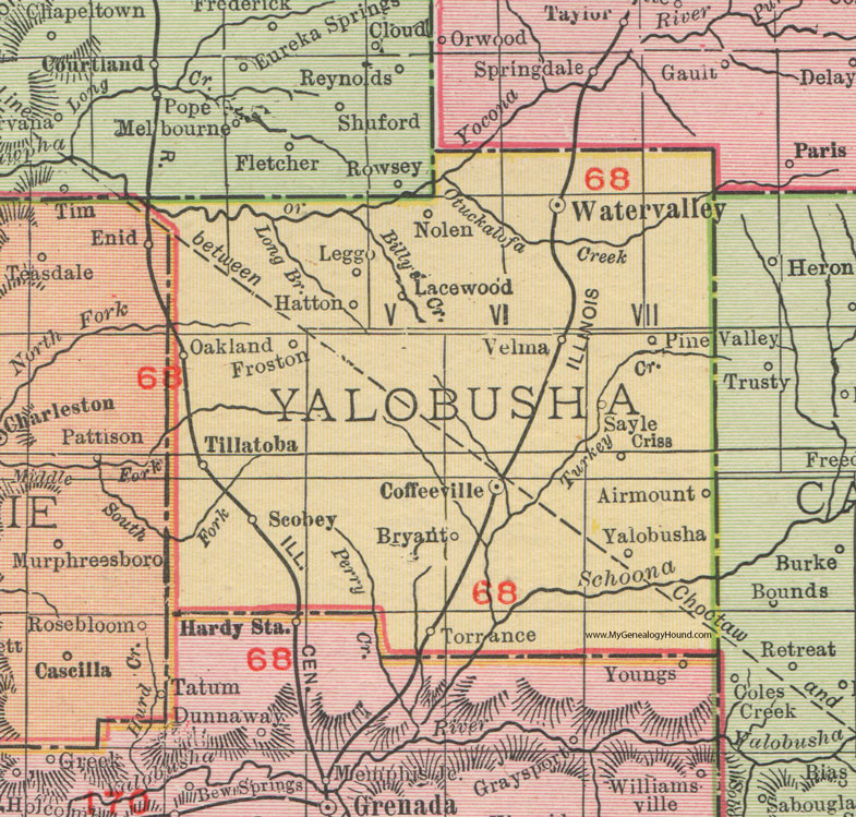
A 1911 Rand McNally map of Yalobusha County, preserved through the Yalobusha County Library System, offers a more localized view. The map identifies Scobey southwest of Coffeeville and south of Tillatoba, along the railroad corridor extending northward from Grenada.
The map also shows the relationship between Scobey and other communities, including Oakland, Hardy, and Water Valley, demonstrating how railroads and roads connected settlements across county boundaries.
These historical maps are particularly useful when compared with later topographic surveys. The United States Geological Survey’s Scobey quadrangle documents the area’s roads, waterways, and other geographical features, providing a framework for investigating how the landscape changed after the period of Scobey’s early development.
For historians studying communities that have changed in size or importance, maps can preserve names and transportation connections that are not always apparent in modern accounts.
What Happened to Scobey?
The historical record establishes that Scobey remained a small railroad and agricultural community during the early twentieth century, but a complete account of its later development requires additional research.
The federal census figures show a population decline between 1910 and 1920, while church association records demonstrate that congregations continued to operate in the surrounding area. Railroad maps from later decades also preserve the transportation system that had originally encouraged the settlement’s development.
However, these sources alone do not establish precisely when individual businesses closed, whether the community experienced a formal change in its municipal status, or how particular families responded to changes in agriculture and railroad operations.
Those questions would require closer examination of county supervisors’ records, municipal documents, local newspapers, and later census materials.
The Mississippi Department of Archives and History maintains Yalobusha County tax rolls and other government records that may help identify property owners and commercial activity. Historical newspapers published in Water Valley, Coffeeville, and Grenada may also contain information about Scobey’s merchants, railroad operations, churches, schools, and families.
Among the most promising newspapers are the North Mississippi Herald, the City Itemizer, the Grenada Sentinel, and the Coffeeville Courier. These publications covered communities throughout the region during the years when Scobey was an active incorporated village.
The survival of these archival collections makes it possible to continue reconstructing the town’s history beyond the limited descriptions available in published county histories.
The Legacy of Scobey, Mississippi
Scobey’s history illustrates the influence that transportation and agriculture exercised over the development of small communities in northern Mississippi. Its origins were connected to the decline of Preston, a settlement that had once supported merchants, physicians, a school, and hundreds of residents before the railroad redirected trade and population toward Garner.
The establishment of Garner’s Station, the development of a federal post office, and the incorporation of Scobey in 1893 marked successive stages in the transformation of the area. By 1907, the community supported two public cotton gins, maintained a money-order post office, and occupied an established position along the Illinois Central Railroad.
Although Scobey never became a large town, its churches, businesses, and transportation connections served families throughout the surrounding countryside. The minutes of the Yalobusha Baptist Association preserve the names of ministers, clerks, and congregations, while census schedules and cemetery inscriptions provide evidence of the residents whose lives formed the community’s history.
Perhaps the most revealing part of Scobey’s story is the relationship between the town and Preston. One settlement declined as another developed, demonstrating how the railroad could transform an established pattern of community life within only a few years.
Yet the story did not end with Preston’s abandonment or Scobey’s modest population decline in the early twentieth century. The families, churches, and historical records associated with both communities form part of the larger history of Yalobusha County and the agricultural railroad towns that shaped northern Mississippi.
Scobey deserves recognition not because it became a major commercial center, but because its history reveals how ordinary communities adapted to changing transportation routes, economic opportunities, and local institutions. Its story remains preserved in the census tables, church minutes, maps, and gravestones that connect the present landscape to the people who lived there generations ago.
Sources & Further Reading
Rowland, Dunbar. Encyclopedia of Mississippi History: Comprising Sketches of Counties, Towns, Events, Institutions and Persons. Vol. 2. Madison, WI: S. A. Brant, 1907. Entry “Scobey,” 624–625. https://ldsgenealogy.com/MS/books/Encyclopedia-of-Mississippi-History-Comprising-Sketches-of-Counties-Towns-Events-Institutions-and-Persons-Vol-II-part-75.htm
Rowland, Dunbar. Encyclopedia of Mississippi History: Comprising Sketches of Counties, Towns, Events, Institutions and Persons. Vol. 2. Madison, WI: S. A. Brant, 1907. Entry “Preston,” 480–481. https://ldsgenealogy.com/MS/books/Encyclopedia-of-Mississippi-History-Comprising-Sketches-of-Counties-Towns-Events-Institutions-and-Persons-Vol-II-part-57.htm
Riley, Franklin L. “Extinct Towns and Villages of Mississippi.” Publications of the Mississippi Historical Society 5 (1902): 311–383. https://books.google.com/books?id=HkgTAAAAYAAJ
Rowland, Dunbar. History of Mississippi: The Heart of the South. Vol. 2. Chicago: S. J. Clarke Publishing Company, 1925. Chapter 48, “Yalobusha County,” 860–862. https://msgw.org/history/yalobusha.htm
Hathorn, Hiram Percy. “Organization and Early History of Yalobusha County.” Master’s thesis, University of Mississippi, 1933. https://egrove.olemiss.edu/etd/1730/
United States Bureau of the Census. Thirteenth Census of the United States: 1910. Population statistics for Mississippi, including counties, minor civil divisions, and incorporated places. Washington, DC: Government Printing Office. https://www2.census.gov/library/publications/decennial/1910/bulletins/demographics/360-population-by-counties-minor-civil-divisions-1910-1900-1890-part-2.pdf
United States Bureau of the Census. Fourteenth Census of the United States: 1920. Population statistics for Mississippi, including comparative population figures for 1900, 1910, and 1920. Washington, DC: Government Printing Office. https://www2.census.gov/prod2/decennial/documents/06229686v20-25ch3.pdf
Mississippi Office of the Secretary of State. Charters of Municipalities. Book 3, 3. Incorporation of Scobey, Yalobusha County, April 8, 1893. Transcribed in “Mississippi Towns Incorporated, 1803–1925.” Genealogy Trails. https://www.genealogytrails.com/miss/towns_incorporated.htm
Yalobusha Baptist Association. Annual Meeting Minutes and Church Records, 1890–1899. Historical transcription, Yalobusha County MSGenWeb. https://msgw.org/yalobusha/history/YBA/minutes/1890minutes.html
Yalobusha Baptist Association. Annual Meeting Minutes and Church Records, 1910–1919. Historical transcription, including Garner and Scobey Baptist congregations. Yalobusha County MSGenWeb. https://msgw.org/yalobusha/history/YBA/minutes/1910minutes.html
Yalobusha Baptist Association. Annual Meeting Minutes and Church Statistics, 1920–1929. Historical transcription, Yalobusha County MSGenWeb. https://msgw.org/yalobusha/history/YBA/minutes/1920minutes.html
Mississippi Railroad Commission. Railroad Commissioners’ Map of Mississippi. 1888. Series 2485. Mississippi Department of Archives and History. https://da.mdah.ms.gov/series/mrc/2485/detail/165074
Mississippi Railroad Commission. Railroad Commissioners’ Map of Mississippi. 1900. Series 2485. Mississippi Department of Archives and History. https://da.mdah.ms.gov/series/mrc/2485/detail/165077
Mississippi Railroad Commission. Railroad Commission Maps, 1888–1936. Series 2485. Mississippi Department of Archives and History, Digital Archives. https://da.mdah.ms.gov/series/mrc/2485
Rand McNally and Company. Railroad Commissioner’s Map of Mississippi. Chicago: Rand McNally, 1888. Library of Congress, Geography and Map Division. https://www.loc.gov/resource/g3981p.rr002430/
Cram, George Franklin. Cram’s Railroad and Township Map of Mississippi. Chicago: George F. Cram, 1882. David Rumsey Historical Map Collection. https://www.davidrumsey.com/luna/servlet/detail/RUMSEY~8~1~332048~90100281
Rand McNally and Company. Yalobusha County, Mississippi. 1911. Historical county map reproduced by the Yalobusha County Library System. https://www.yalobusha.lib.ms.us/wp-content/uploads/2021/09/MS-Yalobusha-County-Mississippi-1911-Map-Rand-McNally.jpg
Mississippi Department of Archives and History. Yalobusha County Tax Rolls. Series 1202. Jackson: Mississippi Department of Archives and History. https://da.mdah.ms.gov/series/osa/s1202/yalobusha
Mississippi Department of Archives and History. Yalobusha County Records, 1833–1971. Series 2050, County Records. Jackson: Mississippi Department of Archives and History. https://finding.mdah.ms.gov/government-records/series-2050
National Archives and Records Administration. Record of Appointment of Postmasters, 1832–1971. Record Group 28, Microfilm Publication M841. Washington, DC: National Archives and Records Administration. https://www.archives.gov/research/post-offices
National Archives and Records Administration. Post Office Department Records of Site Locations, 1837–1955. Record Group 28, Microfilm Publication M1126. Washington, DC: National Archives and Records Administration. https://www.archives.gov/research/post-offices/locations-1837-1950.html
New Hope Presbyterian Church. Session Registers, Births, Baptisms, and Deaths, 1870–1943. Historical church records cataloged in the U.S. Presbyterian Church Records Collection. LDSGenealogy. https://ldsgenealogy.com/MS/Yalobusha-County-Church-Records.htm
Denley, Nick. “Scobey Cemetery.” Cemetery inscription transcription. Yalobusha County MSGenWeb. https://www.msgw.org/yalobusha/churchcem/cemeteries/scobeycem.html
Howe, Tony. “Scobey, Mississippi.” Mississippi Rails. Railroad history, postal chronology, and town incorporation records. https://msrailroads.com/~msrailr1/Towns/Scobey.htm
The North Mississippi Herald. Water Valley, MS, 1888–1929. Historical newspaper collection. Library of Congress, Chronicling America. https://www.loc.gov/item/sn87065497/
The City Itemizer. Water Valley, MS, 1894–1918. Historical newspaper collection. Library of Congress, Chronicling America. https://www.loc.gov/item/sn87065643/
The Grenada Sentinel. Grenada, MS, 1868–1955. Historical newspaper collection. Library of Congress, Chronicling America. https://www.loc.gov/item/sn85034375/
Highsmith, Carol M. “An Old Telephone-Relay Building in Rural Yalobusha County, Mississippi, near the Town of Scobey.” Photograph, November 2, 2016. Carol M. Highsmith Archive, Library of Congress. https://www.loc.gov/item/2017879346/
Adkins, Howard G. The Historical Geography of Extinct Towns in Mississippi. University of Tennessee, Knoxville, 1972. https://trace.tennessee.edu/handle/20.500.14382/29406
Appalachian Regional Commission. “Appalachian Counties Served by ARC.” Washington, DC: Appalachian Regional Commission. https://www.arc.gov/appalachian-counties-served-by-arc/
Author Note: Scobey’s history reveals how railroads transformed small Mississippi communities, drawing families away from older settlements while creating new centers of commerce and community life. If you have family stories, photographs, church records, or historical documents connected to Scobey, Garner, or Preston, I encourage you to share them so that more of this community’s history can be preserved.