
Appalachian History Series – The Baxter Coal Monument: Harlan County’s Coal Obelisk and the Mystery of Its Origins
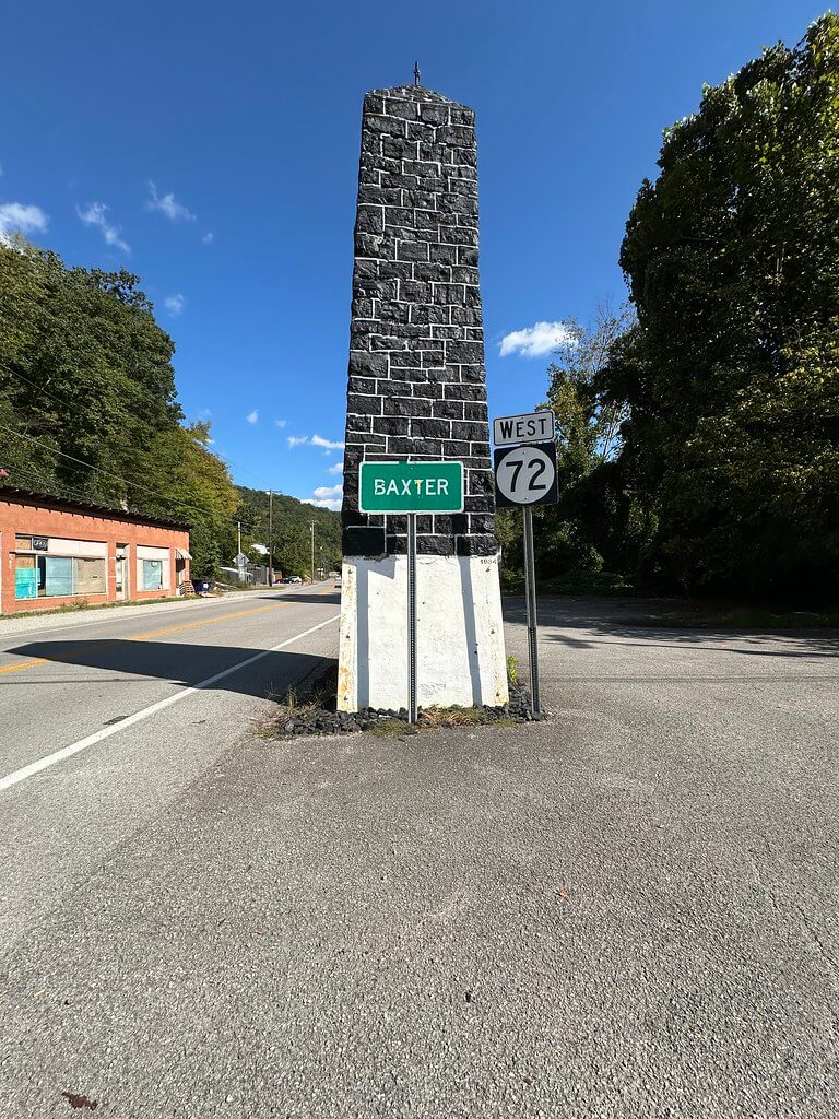
At Baxter, just outside Harlan, one of eastern Kentucky’s strangest monuments rises from a small patch of ground beside the highway. It is not carved from marble, cast in bronze, or built from the limestone that appears in so many courthouses and public memorials. Instead, the dark obelisk is made from the substance that transformed Harlan County more completely than almost anything else: coal.
The Harlan County Coal Monument has stood beside the roads at Baxter for generations, its black surface immediately distinguishing it from the buildings, bridges, road signs, and wooded mountains around it. Harlan County tourism describes the structure as an obelisk erected in honor of the county’s coal industry and says its blocks of coal were contributed by the mines operating in Harlan County when it was constructed. The monument remains one of the county’s recognized historic attractions.
Yet the monument has a historical problem hiding beneath its seemingly simple story. Accounts disagree about exactly when it was built. They disagree about who built it. Some say the Harlan Kiwanis Club sponsored it. Others credit workers from the Works Progress Administration. One modern tradition gives the remarkably precise date of May 22, 1932, while a scholarly publication places its construction in 1934. The surviving research points toward an early 1930s origin, but the contemporary newspaper evidence needed to settle the matter has not yet been located in a form that permits the date to be stated without qualification.
That uncertainty does not make the Baxter Coal Monument less historically important. In some ways, it makes the monument more revealing. Its physical form, its placement at one of Harlan County’s most important old highway junctions, and the stories later attached to its construction show how thoroughly coal shaped the public identity of Harlan County during the Depression years.
A Monument Made From the Industry It Honored
Most monuments merely depict the thing being remembered. Baxter’s monument appears to have been conceived differently. The coal itself became the monument.
Harlan County’s tourism office states that blocks of coal were contributed by each coal mine operating in the county at the time. A chapter in The Palgrave Handbook on Rethinking Colonial Commemorations gives a more specific version of the tradition, placing construction in 1934, crediting the local Kiwanis Club, and reporting that fifty mining companies supplied the large coal blocks. The authors interpret Baxter as an unusually elaborate example of a monument built directly from the commodity it celebrated.
The number fifty is intriguing, but it should be treated cautiously. The Palgrave chapter ultimately traces that specific monument information to a modern video rather than to a surviving 1934 newspaper article or Kiwanis record. Kentucky Department of Mines and Minerals reports from the early 1930s offer a possible way to test the story because they can identify the companies and mines operating in Harlan County during the years when the monument was supposedly constructed. The surviving state mine reports therefore matter for more than statistics. They could eventually help determine whether the remembered story of dozens of companies contributing coal is consistent with the actual structure of Harlan County’s mining industry at the time.
Even without a confirmed list of contributors, the basic tradition is preserved by Harlan County’s own tourism organization, which continues to describe the monument as being assembled from coal supplied by operating mines. That makes the monument a kind of physical map of an industrial county. If the tradition is correct, pieces of coal extracted or supplied from different operations across Harlan County were brought together at Baxter and mortared into one public symbol.
Was the Coal Monument Built in 1932 or 1934?
The greatest difficulty in telling the monument’s story is its date.
One frequently repeated account states that the monument was erected on May 22, 1932. Sam Terry’s Kentucky gives that exact date and describes the structure as honoring Kentucky coal miners and the coal industry. It is a very specific claim and has circulated widely enough to become part of the modern history of the monument. The difficulty is that a precise date repeated many years later is not the same thing as a contemporary record from 1932.
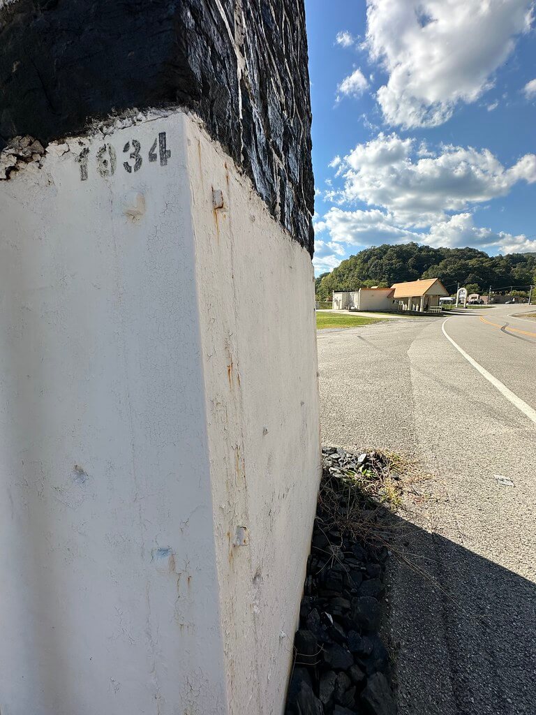
Another source points to 1934. The Palgrave handbook states that the local Kiwanis Club built the monument that year as a conspicuous marker directing visitors toward the mining center of Harlan. That date also fits the general Depression-era setting traditionally associated with the monument, but the chapter’s own citation trail does not lead back to a contemporary Kiwanis minute book, construction document, or newspaper clipping.
For that reason, the Harlan Daily Enterprise remains the most important source for finally resolving the question. Surviving microfilm runs exist for both 1932 and 1934, as well as the surrounding years. A dedication, civic club announcement, construction photograph, editorial, or short notice concerning Baxter could potentially establish not only the year but the sponsor, participating companies, and purpose of the monument. Until such a contemporary notice is found, 1932 and 1934 are best understood as competing dates rather than one proven date and one disproven date.
The distinction matters because the monument has been repeated in roadside histories for so long that later retellings can easily begin to look like independent confirmation. They are not necessarily independent. Several modern accounts may ultimately descend from the same local tradition.
The Problem With the WPA Story
The most easily tested part of the monument’s traditional history concerns the Works Progress Administration.
Some later accounts say WPA labor was used to build the Baxter Coal Monument. If the monument was erected in either 1932 or 1934, however, that statement cannot be correct as written. The National Archives records that the Works Progress Administration was established by Executive Order 7034 on May 6, 1935. A federal agency created in 1935 could not have supplied WPA labor to a monument completed in 1932 or 1934.
That does not necessarily mean the entire New Deal tradition should be discarded. Federal work relief existed before the WPA. The Civil Works Administration, for example, operated from November 1933 through March 1934. It is therefore possible that a later storyteller remembered another relief program as the WPA, that federal workers participated in later improvements or repairs, or that the WPA association simply entered local tradition after the fact. At present, none of those explanations has been documented specifically for the monument, so they should remain possibilities rather than conclusions.
What can be stated firmly is narrower. If the Coal Monument truly dates from 1932 or 1934, it was not originally constructed by the Works Progress Administration under that name.
The Kiwanis story does not face the same chronological problem. A civic organization sponsoring a public marker during the early 1930s is entirely plausible, and the 2023 Palgrave chapter specifically attributes the monument to the local Kiwanis Club. What remains missing is contemporary documentation proving the club’s role.
Why Baxter Was the Right Place
The location of the monument makes considerably more sense when Baxter is viewed through the road system of the early and middle twentieth century rather than through the modern highway landscape.
Baxter sat at an important gateway into Harlan. Nearby, the large Baltimore through truss now known as the Baxter Bridge was constructed in 1924 and 1925 by the Vincennes Bridge Company. HistoricBridges records that the span carried U.S. 119 and that the old junction with U.S. 421 stood at its north end. The bridge was bypassed in 1977 and eventually closed in 1993, but during the period when the Coal Monument appeared it belonged to an important transportation corridor funneling travelers through the Harlan area.
The waterways were just as important. Harlan County tourism identifies Baxter as the place where the great headwater forks come together to form the Cumberland River system. Roads, bridges, railroad infrastructure, streams, and the narrow mountain valleys all converged in this small area, making Baxter far more prominent to travelers than its size alone would suggest.
Seen in that setting, the decision to place a coal obelisk there appears deliberate. Travelers entering the Harlan coalfield could pass a monument made from the mineral that had filled the valleys with mines, tipples, railroads, camps, stores, and new communities. The Palgrave study goes so far as to describe it as a monument intended to guide visitors toward Harlan’s mining center. Whether that was its formally stated purpose still requires contemporary confirmation, but the old highway geography makes the interpretation convincing.
The Coal Monument was therefore not simply an object standing beside a road. The road was part of the monument’s meaning.
A Coal Monument During the Years of Bloody Harlan
The possible construction dates of 1932 and 1934 place the Coal Monument inside one of the most turbulent periods in Harlan County history.
Beginning in 1931, miners, mine operators, union organizers, deputies, and company guards became entangled in the series of strikes, shootings, evictions, arrests, and political confrontations that helped give Harlan County its national reputation as “Bloody Harlan.” The conflict continued through much of the decade, and historian John W. Hevener’s Which Side Are You On? The Harlan County Coal Miners, 1931 to 1939 remains one of the major scholarly studies of that period.
That setting gives the Coal Monument a complicated historical character.
Coal created extraordinary economic growth in Harlan County, bringing railroads, industrial capital, jobs, company towns, commercial development, and thousands of workers into valleys that had been far more isolated only a generation earlier. At the same time, the early Depression brought wage reductions, unemployment, hunger, union conflict, and violence. A monument celebrating the coal industry therefore rose, if the traditional dates are approximately correct, while people throughout the county were arguing bitterly over who actually benefited from that industry and how much power mine operators should exercise over workers and communities.
There is no evidence that the Baxter monument itself was intended as a statement against organized labor, and it would be a mistake to impose that interpretation without documentation. Still, its timing is historically striking. While the newspapers of the nation increasingly associated Harlan County with labor warfare, local boosters could present another image of the county at a major crossroads: a tall obelisk made from Harlan coal.
Both stories belonged to the same place.
The Coal Obelisk Becomes a Landmark
Whatever uncertainty surrounds its beginning, the monument’s later history becomes clearer.
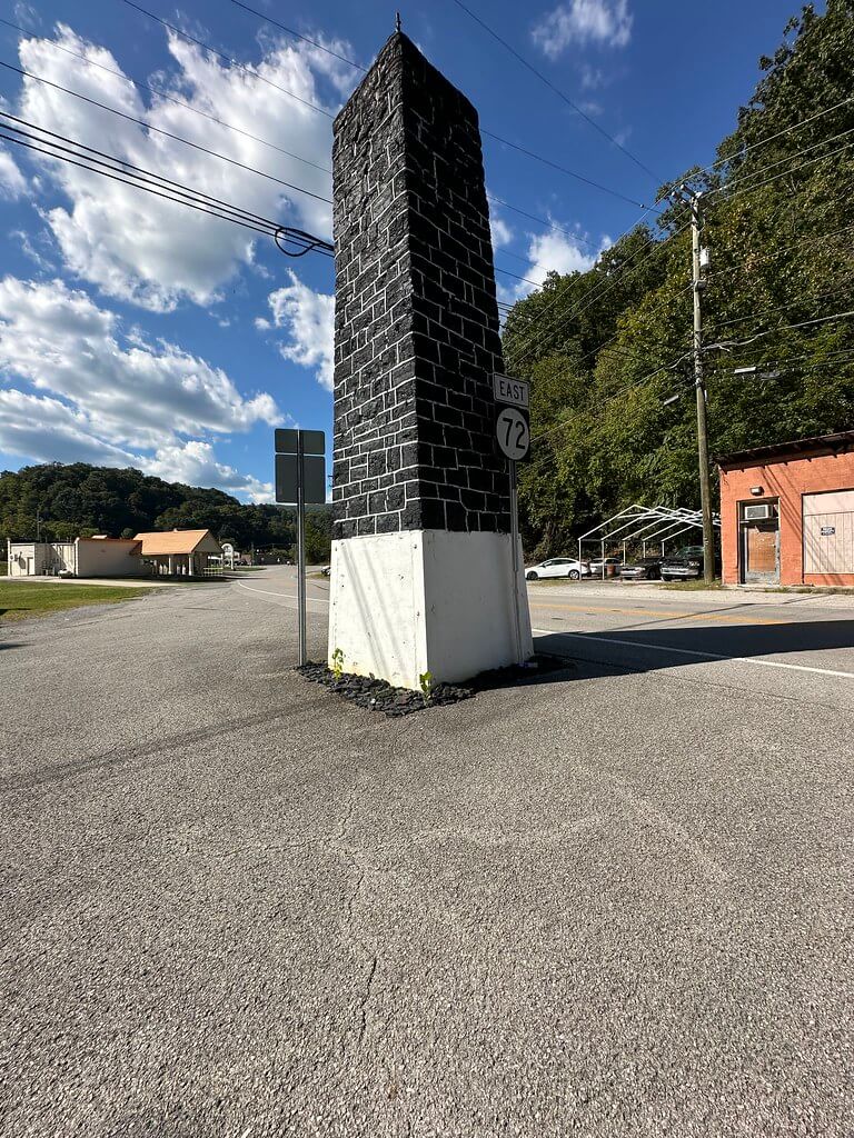
By June 1972 the Harlan Daily Enterprise was referring to it plainly as the “coal obelisk at Baxter.” A June 15 front-page item discussed the monument in connection with a proposal by Paul Spahos and acknowledged that some people had advocated removing it because of traffic concerns. The importance of this newspaper reference is easy to overlook. It demonstrates that by 1972 the structure was not an obscure pile of coal beside an old road. It was a sufficiently recognized landmark for its preservation or removal to become a matter of public discussion.
Only four days later, the newspaper reported another small chapter in the monument’s history. The June 19 edition described work at the Coal Monument at Baxter, where the base had been cleaned of political campaign stickers, mud, and dirt before receiving new coatings. The story provides a rare glimpse of the ordinary maintenance required to keep a roadside landmark alive. Monuments survive not only because someone builds them, but because later residents repeatedly decide they are worth cleaning, painting, repairing, and leaving in place.
The two 1972 newspaper references also reveal something about the monument’s changing surroundings. What may once have functioned as a welcoming industrial marker at a prominent highway junction had become, in the automobile age, an object that some residents regarded as a potential traffic problem. The monument had stayed still while the world around it had changed.
When the Roads Changed Around It
Those changes accelerated during the following decades.
The historic Baxter Bridge that had carried U.S. 119 was bypassed in 1977 when a new U.S. 421 bridge opened. The old structure eventually closed to traffic in 1993. Other bridges and road alignments in the Harlan area were replaced, bypassed, or removed as transportation demands changed.
Then came one of the most ambitious alterations of the landscape in modern Harlan County history. The U.S. Army Corps of Engineers spent roughly a decade constructing the Harlan Flood Control Project, intended to protect Harlan, Baxter, Loyall, and Rio Vista. The completed project was dedicated on October 25, 1999. Its components included floodwalls, river diversion work, tunnels, levees, gates, and changes to waterways that had repeatedly flooded the narrow valleys.
As a result, the Baxter surrounding the Coal Monument today cannot be read as though the roads and rivers occupy precisely the same configuration they did when the obelisk first appeared. The old transportation geography has been layered over by new highways and flood-control engineering.
The monument, however, remained.
From Industrial Advertisement to Historic Landmark
Time has also changed how people look at the Coal Monument.
When it was new, a monument assembled from coal at the entrance to one of America’s most famous mining counties could function as civic promotion. Coal was not being remembered as a vanished industry. It was the industry around which much of Harlan County’s economic life revolved.
A generation later, it was a familiar traffic landmark. By the twenty-first century, it had become heritage.
Harlan County tourism now includes the Coal Monument among twenty-five historic stops across the county, alongside places such as Portal 31, the Benham Historic District, the Harlan County Courthouse, Pine Mountain Settlement School, the old coal camps, and other pieces of the county’s industrial and cultural landscape. The tourism office calls the monument an “iconic piece of Harlan County,” language that would have meant something quite different to the people who originally erected it.
That transformation is common in Appalachia. Structures built for active industries become historical artifacts once the industries contract, transportation patterns shift, and communities begin preserving places their grandparents regarded as ordinary parts of daily life.
The Baxter monument is unusual because it contains the industry within itself. It is not merely located in coal country. It is physically made of coal.
What the Evidence Actually Tells Us
After generations of retelling, the safest history of the Baxter Coal Monument is both more cautious and more interesting than the familiar roadside legend.
The monument is an early twentieth-century coal obelisk in Baxter built to honor Harlan County’s coal industry. Harlan County’s own historical tourism material preserves the tradition that the coal blocks came from mines operating throughout the county. A scholarly study gives 1934 as the year, names the Harlan Kiwanis Club as the builder, and says approximately fifty mining companies contributed material, while another widely circulated account gives May 22, 1932. Neither date has yet been tied publicly to the contemporary newspaper notice needed to settle the question beyond reasonable doubt.
The WPA claim is the one part of the traditional account that creates a definite chronological contradiction. The federal Works Progress Administration did not exist until May 1935. If the monument was standing by 1932 or 1934, some other explanation must account for the later WPA story.
The 1932 and 1934 runs of the Harlan Daily Enterprise are therefore not minor supplemental sources. They are likely the key to the monument’s origins. Finding the first newspaper description of the project could reveal who proposed it, who paid for it, whether the Kiwanis Club formally sponsored it, which mines donated coal, who performed the labor, when construction began, and whether there was a dedication ceremony. The surviving state mine reports could then be compared with any list of contributing operators.
Until that evidence is found, uncertainty should remain part of the story rather than something hidden from it.
The Black Obelisk at Baxter
There are larger monuments in Appalachia and monuments dedicated to people and events far more famous than the little coal obelisk at Baxter. Few, however, are so closely tied to the material that created the community around them.
The monument has watched the roads move around it. It survived debates about traffic, accumulated political stickers and road dirt, received fresh coatings, watched the old highway bridges lose their traffic, and remained while the Army Corps of Engineers reshaped portions of the river system around Harlan and Baxter. The coal industry that once seemed powerful enough to define the county’s future has itself changed dramatically, yet the monument continues to stand beside the road. The 1972 newspaper record and later transportation history document that long transition from active industrial symbol to historic landmark.
Perhaps that is why the Coal Monument remains such an appropriate Harlan County landmark. Its history is not perfectly neat. Industrial pride, Depression hardship, mining companies, miners, civic promotion, old highways, public memory, and local legend have all collected around it.
At Baxter, where roads and waterways have met for generations, Harlan County built a monument from coal itself. Almost a century later, the black obelisk still stands, even as historians continue searching the archives for the full story of who put it there.
Sources & Further Reading
Harlan Daily Enterprise. 1932 newspaper run. University of Kentucky Microfilm Holdings Database. Microfilm S-181, KUK 04559. https://ukmfilms.omeka.net/items/show/73699
Harlan Daily Enterprise. 1934 newspaper run. Harlan, KY. Preserved in the Kentucky Historical Society newspaper microfilm collection. https://www.kyhistory.com/digital/api/collection/LIB/id/1483/download
Harlan Daily Enterprise. June 15, 1972, 1. NewspaperArchive. https://newspaperarchive.com/harlan-daily-enterprise-jun-15-1972-p-1/
Harlan Daily Enterprise. June 19, 1972, 1. NewspaperArchive. https://newspaperarchive.com/harlan-daily-enterprise-jun-19-1972-p-1/
Harlan Daily Enterprise. “Harlan County – Heritage Edition.” February 28, 1984. County Histories of Kentucky, Morehead State University. https://scholarworks.moreheadstate.edu/kentucky_county_histories/101/
Library of Congress. “The Harlan Daily Enterprise (Harlan, Ky.) 1928–2018.” Chronicling America/U.S. Newspaper Directory. https://www.loc.gov/item/sn87060051/
University of Kentucky Libraries. “The Harlan Daily Enterprise (Newspaper).” Notable Kentucky African Americans Database. https://nkaa.uky.edu/nkaa/items/show/300001275
University of Kentucky Libraries. “Kentucky Digital Newspapers and Microfilm.” https://saalck-uky.primo.exlibrisgroup.com/discovery/search?vid=01SAA_UKY%3AKDNP
Kentucky Historical Society. Kentucky Newspapers on Microfilm: 1930–1939. Frankfort: Kentucky Historical Society. https://www.kyhistory.com/digital/api/collection/LIB/id/1483/download
Works Progress Administration and Historical Records Survey. “Harlan County – General History.” 1936. County Histories of Kentucky, Morehead State University. https://scholarworks.moreheadstate.edu/kentucky_county_histories/32/
National Archives and Records Administration. “Records of the Work Projects Administration [WPA], Record Group 69.” Accessed August 12, 2026. https://www.archives.gov/research/guide-fed-records/groups/069.html
National Archives and Records Administration. “Family Experiences and New Deal Relief.” Prologue Magazine. https://www.archives.gov/publications/prologue/2012/fall/fera.html
Middleton, Elmon. Harlan County, Kentucky. Big Laurel, VA: J. T. Adams and J. T. Adams II, 1934. University of Kentucky Libraries catalog record. https://nkaa.uky.edu/nkaa/items/show/300002240
Middleton, Elmon. Harlan County, Kentucky. Big Laurel, VA: J. T. Adams and J. T. Adams II, 1934. Digital copy. https://www.seekingmyroots.com/members/files/H002174.pdf
Hevener, John W. Which Side Are You On? The Harlan County Coal Miners, 1931–39. Urbana: University of Illinois Press, 1978. https://www.press.uillinois.edu/books/?id=p070778
Portelli, Alessandro. They Say in Harlan County: An Oral History. New York: Oxford University Press, 2011. https://global.oup.com/academic/product/they-say-in-harlan-county-9780199934850
Condon, Mabel Green. A History of Harlan County. Nashville: Parthenon Press, 1962. https://www.familysearch.org/library/books/records/item/254223-a-history-of-harlan-county
Fuson, H. H. History of Harlan County, Kentucky: Some Chapters. Harlan, KY, 1942. Bibliographic listing through Pine Mountain Settlement School. https://pinemountainsettlement.net/bibliographies/bibliography-guide/bibliography-harlan-county-kentucky/
Carlson, Bronwyn, and Terri Farrelly, eds. The Palgrave Handbook on Rethinking Colonial Commemorations. Cham, Switzerland: Palgrave Macmillan, 2023. https://link.springer.com/book/10.1007/978-3-031-28609-4
Harlan County Tourism. “25 Historic Stops in Harlan County.” Accessed August 12, 2026. https://www.harlancountytrails.com/blog/25-historic-stops-in-harlan-county/
Harlan County Public Libraries. “Resources.” Accessed August 12, 2026. https://harlancountylibraries.org/index.php/resources/
Asher, Joe. “Iconic Harlan County Bridge Sees 100 Years.” Harlan Enterprise, July 31, 2024. https://harlanenterprise.net/2024/07/31/iconic-harlan-county-bridge-sees-100-years/
HistoricBridges.org. “Baxter Bridge and Old Highway 119 Bridge, Harlan County, Kentucky.” Accessed August 12, 2026. https://historicbridges.org/b_h_fipsm.php?bsearch=21095
U.S. Army Corps of Engineers, Nashville District. “Harlan Flood Control Project Dedicated 20 Years Ago.” October 25, 2019. https://www.lrd.usace.army.mil/Media/News/Article/3729323/harlan-flood-control-project-dedicated-20-years-ago/
Sanborn Map Company. Sanborn Fire Insurance Map from Harlan, Harlan County, Kentucky. October 1932. Washington, DC: Library of Congress Geography and Map Division. https://www.loc.gov/resource/g3954hm.g031771932/
U.S. Geological Survey. Harlan Quadrangle, Kentucky. 1:24,000. Washington, DC: U.S. Geological Survey, 1954. https://prd-tnm.s3.amazonaws.com/StagedProducts/Maps/HistoricalTopo/PDF/KY/24000/KY_Harlan_803596_1954_24000_geo.pdf
United States. Federal Register. “Harlan Road, U.S. 119, Kentucky.” January 8, 1972. https://www.govinfo.gov/content/pkg/FR-1972-01-08/pdf/FR-1972-01-08.pdf
Author Note: The Baxter Coal Monument is one of Harlan County’s most recognizable roadside landmarks, but its origin story becomes less certain the closer the surviving evidence is examined. I wanted to separate the documented history from later tradition while preserving the monument’s place in the county’s coalfield memory.